 My GeoNetwork catalogue
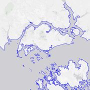
TanDEM-X High-Resolution Coastline - Global, 10m
The global TanDEM-X High-Resolution Coastline Product was developed by the German Remote Sensing Data Center (DFD) at the German Aerospace Center (DLR) as part of the TanDEM-X Mission and the HydroSHEDS v2.0 project. It is a global vector dataset that outlines the boundary between terrestrial and marine environments at a resolution of 10 meters. Between 2010 and 2015, the TanDEM-X mission acquired a complete coverage of the Earth's landmass, resulting in a global digital elevation model (DEM). Since the TanDEM-X coastline is derived from the TanDEM-X dataset, it provides an optimal fit for improving the DEM. Additionally, the TanDEM-X coastline is a key component in the derivation of hydrographic data within the HydroSHEDS v2.0 project, where it defines the outer boundary of watersheds and river networks. To meet hydrological requirements and to ensure global consistency, the TanDEM-X coastline was extracted automatically in a first step and subsequently manually verified and refined. Since the coastline is a mapping feature located in the coastal zone, its position is a function of the source data, the method used to identify the coastline, the time of acquisition, and the purpose of mapping.
- Identification
- Distribution
- Quality
- Spatial rep.
- Ref. system
- Content
- Portrayal
- Metadata
- Md. constraints
- Md. maintenance
- Schema info
Identification
Data identification
Citation
- Date (Creation)
- 2026-01-13T12:48:00
- Citation identifier
- https://geoservice.dlr.de/catalogue/srv/metadata/0ebf3708-07da-40d0-a8ca-078110e546e5
- Presentation form
- Digital map
- Other citation details
-
DOI: 10.15489/entfdgi5es81
- Status
- Completed
- Maintenance and update frequency
- As needed
-
GEMET - INSPIRE themes, version 1.0
-
-
Land cover
-
Hydrography
-
- Keywords
-
-
DLR
-
EOC
-
DFD
-
Terrestial Hydrosphere
-
TanDEM-X
-
digital elevation model
-
DEM
-
coastline
-
shoreline mapping
-
opendata
-
- Use limitation
-
Nutzungseinschränkungen: Das DLR ist nicht haftbar für Schäden, die sich aus der Nutzung ergeben. / Use Limitations: DLR not liable for damage resulting from use.
Legal constraints
- Access constraints
- Other restrictions
- Other constraints
- Es gelten keine Zugriffsbeschränkungen
Legal constraints
- Use constraints
- Other restrictions
- Other constraints
-
Nutzungsbedingungen: Lizenz, https://creativecommons.org/licenses/by/4.0 / Terms of use: License, https://creativecommons.org/licenses/by/4.0
- Other constraints
-
{"id": "cc-by-4.0",
"name": "Creative Commons Namensnennung 4.0 International (CC BY 4.0)",
"url": " http://dcat-ap.de/def/licenses/cc-by/4.0 ",
"quelle": "Copyright DLR (year of production)"}
- Spatial representation type
- Vector
- Denominator
- 20000
- Language
- English
- Character set
- UTF8
- Topic category
-
- Imagery base maps earth cover
Extent
))
- Begin date
- 2010-12-10T00:00:00
- End date
- 2015-01-15T00:00:00
Distribution
Distribution
- Distribution format
-
-
Esri Shapefile
()
-
GeoPackage
()
-
Esri Shapefile
()
Digital transfer options
- OnLine resource
- EOC Download Service ( WWW:LINK-1.0-http--link )
- OnLine resource
- TanDEM-X Mission Website ( WWW:LINK-1.0-http--link )
- OnLine resource
- HydroSHEDS v2 Website ( WWW:LINK-1.0-http--link )
- OnLine resource
- EOC Geoservice Dataset ( WWW:LINK-1.0-http--link )
Quality
Data quality
- Hierarchy level
- Dataset
Domain consistency
- Measure identification
- INSPIRE / Conformity_001
Conformance result
Citation
- Date (Publication)
- 2010-12-08
- Explanation
-
See the referenced specification.
- Pass
- Yes
Lineage
- Statement
-
Input data: The TanDEM-X coastline product is based on the first global TanDEM-X DEM, consisting of data acquired by the TanDEM-X mission between 10 December 2010 and 15 January 2015. Global reference lines are consulted for manual corrections.
- Description
-
The TanDEM-X coastline extraction is a semi-automatic process. The first stage is the automatic extraction from TanDEM-X data. In the second stage, the automatically derived coastline is manually modified.
The global TanDEM-X High-Resolution Coastline Product has a resolution of 10 meters. A quantitative and qualitative comparison with other coastline products reveals the overall high quality of the TanDEM-X coastline.
Ref. system
- Unique resource identifier
- EPSG:3395
Metadata
Metadata
- File identifier
- 0ebf3708-07da-40d0-a8ca-078110e546e5 XML
- Metadata language
- English
- Character set
- UTF8
- Hierarchy level
- Dataset
- Hierarchy level name
-
Dataset
- Date stamp
- 2026-01-15T09:36:21
- Metadata standard name
-
ISO 19115-1:2014/19139
- Metadata standard version
-
2003/Cor.1:2006
Overviews

Spatial extent
Provided by
