 My GeoNetwork catalogue
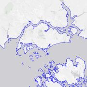
TanDEM-X High-Resolution Coastline - Global, 10m
The global TanDEM-X High-Resolution Coastline Product was developed by the German Remote Sensing Data Center (DFD) at the German Aerospace Center (DLR) as part of the TanDEM-X Mission and the HydroSHEDS v2.0 project. It is a global vector dataset that outlines the boundary between terrestrial and marine environments at a resolution of 10 meters. Between 2010 and 2015, the TanDEM-X mission acquired a complete coverage of the Earth's landmass, resulting in a global digital elevation model (DEM). Since the TanDEM-X coastline is derived from the TanDEM-X dataset, it provides an optimal fit for improving the DEM. Additionally, the TanDEM-X coastline is a key component in the derivation of hydrographic data within the HydroSHEDS v2.0 project, where it defines the outer boundary of watersheds and river networks. To meet hydrological requirements and to ensure global consistency, the TanDEM-X coastline was extracted automatically in a first step and subsequently manually verified and refined. Since the coastline is a mapping feature located in the coastal zone, its position is a function of the source data, the method used to identify the coastline, the time of acquisition, and the purpose of mapping.
INSPIRE
Identification
- File identifier
- 0ebf3708-07da-40d0-a8ca-078110e546e5 XML
- Hierarchy level
- Dataset
Online resource
- Protocol
-
WWW:LINK-1.0-http--link
- Protocol
-
WWW:LINK-1.0-http--link
- Protocol
-
WWW:LINK-1.0-http--link
- Protocol
-
WWW:LINK-1.0-http--link
Resource identifier
- Metadata language
- English
- Spatial representation type
- Vector
Projection
- code
- EPSG:3395
Classification of data and services
- Topic category
-
- Imagery base maps earth cover
Classification of data and services
Coupled resource
Coupled resource
Classification of data and services
Coupled resource
Coupled resource
Keywords
-
GEMET - INSPIRE themes, version 1.0
-
-
Land cover
-
Hydrography
-
Other keywords
- Keywords
-
-
DLR
-
EOC
-
DFD
-
Terrestial Hydrosphere
-
TanDEM-X
-
digital elevation model
-
DEM
-
coastline
-
shoreline mapping
-
opendata
-
Geographic coverage
))
Temporal reference
Temporal extent
- Begin
- 2010-12-10T00:00:00
- End
- 2015-01-15T00:00:00
Temporal extent
- Date (Creation)
- 2026-01-13T12:48:00
Quality and validity
- Lineage
-
Input data: The TanDEM-X coastline product is based on the first global TanDEM-X DEM, consisting of data acquired by the TanDEM-X mission between 10 December 2010 and 15 January 2015. Global reference lines are consulted for manual corrections.
- Denominator
- 20000
Conformity
Conformity
Conformity
Conformity
Conformity
Conformity
- Explanation
-
See the referenced specification.
Restrictions on access and use
- Access constraints
- Es gelten keine Zugriffsbeschränkungen
- Access constraints
-
Nutzungsbedingungen: Lizenz, https://creativecommons.org/licenses/by/4.0 / Terms of use: License, https://creativecommons.org/licenses/by/4.0
- Access constraints
-
{"id": "cc-by-4.0",
"name": "Creative Commons Namensnennung 4.0 International (CC BY 4.0)",
"url": " http://dcat-ap.de/def/licenses/cc-by/4.0 ",
"quelle": "Copyright DLR (year of production)"}
Responsible organization (s)
Contact for the resource
- Organisation name
-
German Aerospace Center (DLR)
- Organisation name
-
German Aerospace Center (DLR)
Responsible organization (s)
Contact for the resource
- Organisation name
-
German Aerospace Center (DLR)
- Organisation name
-
German Aerospace Center (DLR)
Metadata information
Contact for the metadata
- Organisation name
-
German Aerospace Center (DLR)
- Date stamp
- 2026-01-15T09:36:21
- Metadata language
- English
- Character set
- UTF8
SDS
Conformance class 1: invocable
Access Point URL
Endpoint URL
Technical specification
Conformance class 2: interoperable
Access constraints
Limitation
Use constraints
Limitation
Responsible custodian
Contact for the resource
Overviews

Spatial extent
Provided by
