 My GeoNetwork catalogue
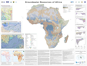
Groundwater Resources of Africa (WHYMAP GWRA)
The Groundwater Resources of Africa Map represents the current state of WHYMAP’s groundwater resources mapping in Africa and was prepared for the 7th Africa Water Week 2018 in Libreville (Gabon). It includes novel features, such as cross-sections and regional transboundary hydrogeological maps, bringing together generalised overview maps and regional hydrogeological studies, thereby adding value through the inclusion of higher resolution spatial information in regions where ongoing BGR technical cooperation projects are taking place. These regional mapping activities methodologically follow the spirit of the development of the International Hydrogeological Map of Europe (IHME1500), the only harmonised, pan-European dataset at a scale of 1:1?500?000. For the IHME1500, a lithological classification scheme was developed at BGR (Duscher et al., 2015) and combined with the Standard Legend for Hydrogeological Maps (SLHyM) of Struckmeier & Margat (1995). The regional maps apply this European approach to the mapping of groundwater resources in Africa. These medium-scale maps are a further step towards regional integrated water resources planning and allow for specific analyses, such as vulnerability assessments of groundwater resources to climate change and pollution. The World-wide Hydrogeological Mapping and Assessment Programme (WHYMAP) is a joint programme consisting of a consortium composed by the UNESCO, the Commission for the Geological Map of the World (CGMW), the International Association of Hydrogeologists (IAH), the International Atomic Energy Agency (IAEA), the International Groundwater Resources Assessment Centre (IGRAC), and the German Federal Institute for Geosciences and Natural Resources (BGR). Its main objective is to contribute to the global effort to better understand, manage and protect aquifer resources, and to communicate this groundwater-related information appropriately to groundwater experts, non-experts and policy-makers.
- Identification
- Distribution
- Quality
- Spatial rep.
- Ref. system
- Content
- Portrayal
- Metadata
- Md. constraints
- Md. maintenance
- Schema info
Identification
Data identification
Citation
- Alternate title
-
WHYMAP GWRA
- Date (Publication)
- 2018-10-01
- Edition
-
v1.0
- Citation identifier
- a0e7e26d-6988-569d-aef0-50403fbd29c5
- Citation identifier
- https://doi.org/10.25928/WHYMAP-GWRA.1
- Other citation details
-
BGR and UNESCO (2018): Groundwater Resources of Africa – Special edition for the 7th Africa Water Week 1:12 500 000. Berlin and Paris. DOI: 10.25928/WHYMAP-GWRA.1
- Status
- Completed
-
GEMET - INSPIRE themes, version 1.0
-
-
Geologie
-
Geology
-
-
GEMET - Concepts, version 2.4
-
-
Grundwasser
-
Hydrogeologie
-
Groundwater
-
Hydrogeology
-
- Theme
-
-
Aquifer
-
Grundwasserneubildung
-
Groundwater recharge
-
Grundwasservorkommen
-
Groundwater resources
-
Grundwasserentnahme
-
Groundwater abstraction
-
- Place
-
-
Africa
-
Afrika
-
Legal constraints
- Access constraints
- Other restrictions
- Other constraints
- Es gelten keine Zugriffsbeschränkungen
Legal constraints
- Use constraints
- Other restrictions
- Other constraints
-
Allgemeine Geschäftsbedingungen, s.: https://www.bgr.bund.de/AGB - General terms and conditions, s. https://www.bgr.bund.de/AGB_en ; Die bereitgestellten Informationen sind bei Weiterverwendung wie folgt zu zitieren: Datenquelle: WHYMAP GWRA © BGR & UNESCO 2018
- Spatial representation type
- Vector
- Denominator
- 12500000
- Language
- English
- Character set
- UTF8
- Topic category
-
- Geoscientific information
))
Distribution
Distribution
- Distribution format
-
-
Shapefile
(
n/a
)
-
PDF
(
n/a
)
-
Shapefile
(
n/a
)
- OnLine resource
-
WHYMAP GWRA (Shapefile)
WHYMAP GWRA im Format ESRI Shape
- OnLine resource
- Website
- OnLine resource
-
WHYMAP GWRA (PDF)
WHYMAP GWRA im Format PDF
Quality
Data quality
Scope
- Hierarchy level
- Dataset
- Statement
-
World-wide Hydrogeological Mapping and Assessment Programme (WHYMAP)
Ref. system
- Unique resource identifier
- EPSG:4326
Metadata
Metadata
- File identifier
- 16874907-e281-4c21-94f4-1a5b04040e80 XML
- Metadata language
- English
- Character set
- UTF8
- Hierarchy level
- Dataset
- Hierarchy level name
-
Grundwasser
- Date stamp
- 2025-03-12
- Metadata standard name
-
INSPIRE Metadata Implementing Rules: Technical Guidelines based on EN ISO 19115 and EN ISO 19119
- Metadata standard version
-
n/a
Overviews
Spatial extent
Provided by
