 www.geodatenkatalog.de (S3L)
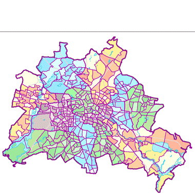
Lebensweltlich orientierte Räume (LOR) - Planungsräume (01.01.2019)
Dargestellt werden die 448 Planungsräume, die die unterste Beobachtungs- und Planungsebene der lebensweltlich orientierten Raumhierarchie (LOR) im RBS abbilden. Durchschnittlich umfaßt ein Planungsraum 7.500 Einwohner
|
|
Citation proposal
(2016) . Lebensweltlich orientierte Räume (LOR) - Planungsräume (01.01.2019). https://gdk.gdi-de.org/geonetwork/srv/api/records/1ed0213c-00a4-34a9-936e-edb1490b012a |
Simple
Identification info
- Date ( Creation )
- 2015-12-31
- Date ( Publication )
- 2016-03-02
- Date ( Revision )
- 2019-01-01
- Presentation form
- Digital map
Point of contact
Point of contact
- Keywords ( Theme )
-
- open data
- opendata
- Karten
- Geodaten
- Berlin
- RBS
- Hierarchie
- Planungsraum
- Access constraints
- Other restrictions
- Use constraints
- Other restrictions
- Other constraints
- Der Datenbestand wird unter der Lizenz CC-BY-3.0-Namensnennung veröffentlicht (vgl. https://creativecommons.org/licenses/by/3.0/de/ ). Als Urheber ist dabei zu nennen: Amt für Statistik Berlin-Brandenburg
- Other constraints
- {"id": "CC BY 3.0 DE" , "name": "Creative Commons - Namensnennung 3.0 Deutschland", "url": "https://creativecommons.org/licenses/by/3.0/de/", "quelle": "Amt für Statistik Berlin-Brandenburg" }
- Service Type
- view
- Service Version
- OGC:WMS 1.0.0
- Service Version
- OGC:WMS 1.1.0
- Service Version
- OGC:WMS 1.1.1
- Service Version
- OGC:WMS 1.3.0
N
S
E
W
))
- Extent type code
- true
- Geographic identifier
- 110000000000
- Coupling Type
- Tight
Contains Operations
- Operation Name
- GetCapabilities
- Distributed Computing Platforms
- Web services
- Connect Point
- https://fbinter.stadt-berlin.de/fb/wms/senstadt/lor_plan
- Reference system identifier
- http://www.opengis.net/def/crs/EPSG/0/25833
- Distribution format
-
- Text/HTML (4.01 )
- OnLine resource
-
GetCapabilities Aufruf des WMS mit maschinenlesbarer Antwort
GetCapabilities Aufruf des WMS mit maschinenlesbarer Antwort
- OnLine resource
-
Aufruf des Geoportals Berlin mit Darstellung der Karte und weiterer Metadaten
Aufruf des Geoportals Berlin mit Darstellung der Karte und weiterer Metadaten
- OnLine resource
-
Inhaltliche Beschreibung
Inhaltliche Beschreibung
- Hierarchy level
- Service
- Other
- Dienst
gmd:MD_Metadata
- File identifier
- 1ed0213c-00a4-34a9-936e-edb1490b012a XML
- Metadata language
- German
- Character set
- UTF8
- Hierarchy level
- Service
- Hierarchy level name
- Lebensweltlich orientierte Räume (LOR) - Planungsräume (01.01.2019) Dienst
- Date stamp
- 2023-08-16T11:19:18
- Metadata standard name
- ISO 19115/19119 – BE
- Metadata standard version
- 1.0.0
Overviews
Vorschaugrafik

Legende
Provided by

Views
1ed0213c-00a4-34a9-936e-edb1490b012a
Access to the portal
Read here the full details and access to the data.
Associated resources
Not available