 My GeoNetwork catalogue
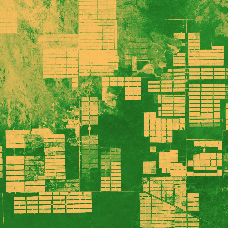
Geo-ForPy - Forest Structure Information for the Paraguayan Chaco - Sentinel-1/2/GEDI, 2019
The dataset is based on an analysis combining Sentinel-1 (SAR), -2 (Multispectral) and GEDI (Global Ecosystem Dynamics Investigation, LiDAR) data to model vegetation structure information.
The derived products show high-spatial resolution maps (10 m) of total canopy cover (cover density in %), Foliage height diversity (Fhd) index in meter, Plant area index (Pai) in meter and canopy height (rh95) in meter.
INSPIRE
Identification
- File identifier
- 1ef2d116-ee75-4a22-a83c-572fc0238821 XML
- Hierarchy level
- Dataset
Online resource
- Protocol
-
OGC:WMS
- Protocol
-
OGC:WMS
- Protocol
-
OGC:WMS
- Protocol
-
OGC:WMS
- Protocol
-
WWW:LINK-1.0-http--link
- Protocol
-
WWW:LINK-1.0-http--link
- Protocol
-
WWW:LINK-1.0-http--link
Resource identifier
- Metadata language
- English
- Spatial representation type
- Grid
Encoding
- Format
-
GeoTIFF
Projection
Classification of data and services
- Topic category
-
- Biota
Classification of data and services
Coupled resource
Coupled resource
Classification of data and services
Coupled resource
Coupled resource
Keywords
-
GEMET - INSPIRE themes, version 1.0
-
-
Land cover
-
Other keywords
- Keywords
-
-
opendata
-
DLR
-
EOC
-
GeoForPy
-
Forest
-
Forest Structure
-
Sentinel-1
-
Sentinel-2
-
GEDI
-
Paraguay
-
Geographic coverage
))
Temporal reference
Temporal extent
- Begin
- 2019-04-01T00:00:00
- End
- 2019-09-30T23:59:59
Temporal extent
- Date (Creation)
- 2022-09-01T00:00:00
Quality and validity
- Lineage
-
This dataset provides large-scale information on vegetation structure information (canopy height, total canopy cover, plant area index, foliage height diversity index), that allows for a complete understanding of spatial characteristics for the complete Paraguayan Chaco, when combined with the other modelled data sets.
- Denominator
- 20000
Conformity
Conformity
Conformity
Conformity
Conformity
Conformity
- Explanation
-
See the referenced specification.
Restrictions on access and use
- Access constraints
- There are no limitations on public access to spatial data sets and services.
- Access constraints
-
Nutzungsbedingungen: Lizenz, https://creativecommons.org/licenses/by/4.0/ Terms of use: License, https://creativecommons.org/licenses/by/4.0/
- Access constraints
-
{"id": "cc-by-4.0",
"name": "Creative-Commons - Attribution 4.0 International (CC BY 4.0)",
"url": " http://dcat-ap.de/def/licenses/cc-by/4.0 ",
"quelle": "Copyright DLR (2022)"}
Responsible organization (s)
Contact for the resource
- Organisation name
-
German Aerospace Center (DLR)
- Organisation name
-
German Aerospace Center (DLR)
Responsible organization (s)
Contact for the resource
- Organisation name
-
German Aerospace Center (DLR)
- Organisation name
-
German Aerospace Center (DLR)
Metadata information
Contact for the metadata
- Organisation name
-
German Aerospace Center (DLR)
- Date stamp
- 2024-06-20T13:06:55
- Metadata language
- English
- Character set
- UTF8
SDS
Conformance class 1: invocable
Access Point URL
Endpoint URL
Technical specification
Conformance class 2: interoperable
Access constraints
Limitation
Use constraints
Limitation
Responsible custodian
Contact for the resource
Overviews
Spatial extent
Provided by
