 My GeoNetwork catalogue
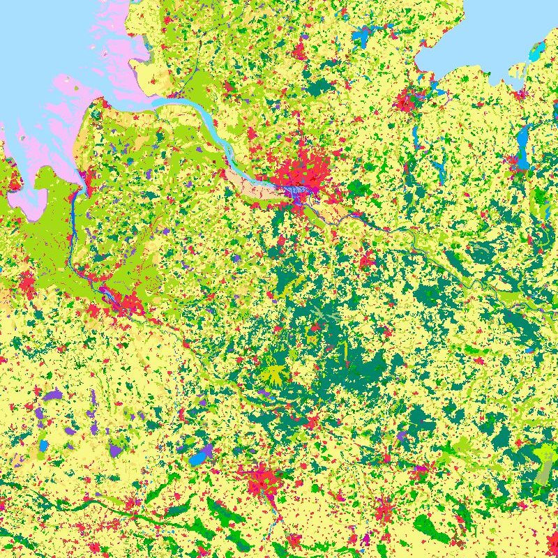
CORINE Land Cover 2000 - Germany
The objective of the pan-European project CORINE Land Cover (CLC) is the provision of a unique and comparable data set of land cover for Europe and the delivery of regular updates to register also the land cover and land use changes over time. It is part of the European Union programme CORINE (Coordination of Information on the Environment). The mapping of the land cover and land use was performed on the basis of satellite remote sensing images. The first CLC data base CLC1990, which was finalized in the 1990s, consistently provided land use information comprising 44 classes, out of which 37 classes are relevant in Germany. The first two updates for Europe were based on the reference years 2000 and 2006. For Germany, DLR-DFD was responsible for the creation of CLC2000 and CLC2006 on behalf of the Federal Environment Agency. In addition to the updated land cover, change datasets were also parts of the project. For deriving a meaningful CLC2000 change product, it became necessary to re-interprete parts of the satellite data of 1990 and to create a revised product, called CLC1990 (rev).
Further details:
https://www.dlr.de/en/eoc/research-transfer/projects-missions/corine-land-cover
INSPIRE
Identification
- File identifier
- 229eccaf-bace-4e93-b8a5-a66568993b0f XML
- Hierarchy level
- Dataset
Online resource
- Protocol
-
OGC:WMS
- Protocol
-
OGC:WMS
- Protocol
-
OGC:WMS
- Protocol
-
OGC:WMS
- Protocol
-
OGC:WMS
- Protocol
-
WWW:LINK-1.0-http--link
- Protocol
-
WWW:LINK-1.0-http--link
Resource identifier
- Metadata language
-
eng
- Spatial representation type
- Grid
Encoding
Projection
- code
-
ETRS89 / LAEA Europe (EPSG:3035)
- code
-
ETRS89 / UTM zone 32N (N-E) (EPSG:3044)
Classification of data and services
- Topic category
-
- Imagery base maps earth cover
Classification of data and services
Coupled resource
Coupled resource
Classification of data and services
Coupled resource
Coupled resource
Keywords
-
GEMET - INSPIRE themes, version 1.0
-
-
Land cover
-
Other keywords
- Keywords
-
-
CORINE
-
CORINE_2000
-
Germany
-
Geographic coverage
))
Temporal reference
Temporal extent
- Begin
- 2004-12-21
Temporal extent
- Date (Creation)
- 2004-12-21T00:00:00
Quality and validity
- Lineage
-
For details see:
https://www.dlr.de/en/eoc/research-transfer/projects-missions/corine-land-cover and https://geoservice.dlr.de/resources/pdf/corine/CORINE_Land_Cover_products_for_Germany_at_DFD.pdf
- Denominator
- 200000
Conformity
Conformity
Conformity
Conformity
Conformity
Conformity
- Explanation
-
Keil, M., Kiefl, R., Strunz, G. (2005): CORINE Land Cover 2000 - Germany. Final Report. German Aerospace Center, German Remote Sensing Data Center Oberpfaffenhofen, July 2005.
https://www.umweltbundesamt.de/sites/default/files/medien/publikation/long/3212.pdf
Restrictions on access and use
- Access constraints
-
Nutzungsbedingungen: For terms of use, see https://geoservice.dlr.de/resources/licenses/corine/CORINE_termsofuse_en.pdf Reference for the use of CLC2000 products in publications: CORINE Land Cover (CLC2000); Federal Environment Agency, DLR-DFD 2004.
Responsible organization (s)
Contact for the resource
- Organisation name
-
German Aerospace Center (DLR)
- Organisation name
-
German Federal Environmental Agency (UBA)
Responsible organization (s)
Contact for the resource
- Organisation name
-
German Aerospace Center (DLR)
- Organisation name
-
German Federal Environmental Agency (UBA)
Metadata information
Contact for the metadata
- Organisation name
-
German Aerospace Center (DLR)
- Date stamp
- 2024-09-27T14:14:48
- Metadata language
- English
- Character set
- UTF8
SDS
Conformance class 1: invocable
Access Point URL
Endpoint URL
Technical specification
Conformance class 2: interoperable
Access constraints
Limitation
Use constraints
Limitation
Responsible custodian
Contact for the resource
Overviews
Spatial extent
Provided by
