 My GeoNetwork catalogue
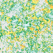
GrassLands - Mowing Frequency - Yearly, 10m
Grassland mowing dynamics (i.e. the timing and frequency of mowing events) have a strong impact on grassland functions and yields. As grasslands in Germany are managed on small-scale units and grass grows back quickly, satellite information with high spatial and temporal resolution is necessary to capture grassland mowing dynamics. Based on Sentinel-2 data time series, mowing events are detected throughout Germany and annual maps of the grassland mowing frequency generated. The grassland mowing detection approach operates per pixel, including preprocessing of the Enhanced Vegetation Index (EVI) time series and a calibrated rule-based grassland mowing detection which is specified in more detail in Reinermann et al. 2022, 2023.
- Identification
- Distribution
- Quality
- Spatial rep.
- Ref. system
- Content
- Portrayal
- Metadata
- Md. constraints
- Md. maintenance
- Schema info
Identification
Data identification
Citation
- Date (Creation)
- 2025-04-15
- Citation identifier
- https://geoservice.dlr.de/catalogue/srv/metadata/242a4f00-c6bf-4d53-a2ec-fd20a2895b7b
- Presentation form
- Digital map
- Purpose
-
Information on grassland mowing frequency, i.e. the number of mowing events per year, are meaningful for scientific analyses of grassland ecosystem services, including yields, biodiversity, nutrient storage and fluxes (e.g. N, C), erosion and water quality. In addition, the mowing frequency reflects the use intensity and can be of interest for authorities and the general public.
- Status
- ongoing
- Maintenance and update frequency
- As needed
-
GEMET - INSPIRE themes, version 1.0
-
-
Land use
-
- Keywords
-
-
DLR
-
EOC
-
Germany
-
Agriculture
-
Mowing
-
Cutting
-
meadow
-
grassland management
-
Sentinel-2
-
opendata
-
- Use limitation
-
Nutzungseinschränkungen: Das DLR ist nicht haftbar für Schäden, die sich aus der Nutzung ergeben. / Use Limitations: DLR not liable for damage resulting from use.
Legal constraints
- Access constraints
- Other restrictions
- Other constraints
- Es gelten keine Zugriffsbeschränkungen
Legal constraints
- Use constraints
- Other restrictions
- Other constraints
-
Nutzungsbedingungen: Lizenz, https://creativecommons.org/licenses/by/4.0 / Terms of use: License, https://creativecommons.org/licenses/by/4.0
- Other constraints
-
{"id": "cc-by-4.0",
"name": "Creative Commons Namensnennung - 4.0 International (CC BY 4.0)",
"url": " http://dcat-ap.de/def/licenses/cc-by/4.0 ",
"quelle": "Copyright DLR (year of production)"}
- Spatial representation type
- Grid
- Denominator
- 20000
- Language
- English
- Character set
- UTF8
- Topic category
-
- Farming
Extent
))
- Begin date
- 2018-01-01T00:00:00Z
Distribution
Distribution
- Distribution format
-
-
GeoTIFF
()
-
GeoTIFF
()
Digital transfer options
- OnLine resource
-
GL_MOW_DE_P1Y_FREQ
(
OGC:WMS
)
EOC Land Map Service
- OnLine resource
- EOC Geoservice Dataset ( WWW:LINK-1.0-http--link )
- OnLine resource
- HTTP Download Service ( WWW:LINK-1.0-http--link )
- OnLine resource
- EOC STAC Collection ( WWW:LINK-1.0-http--link )
Quality
Data quality
- Hierarchy level
- Series
Domain consistency
- Measure identification
- INSPIRE / Conformity_001
Conformance result
Citation
- Date (Publication)
- 2010-12-08
- Explanation
-
See the referenced specification.
- Pass
- Yes
Lineage
- Statement
-
All available Sentinel-2 data of the respective year for the whole of Germany are used.
- Description
-
Processing: Sentinel-2 Enhanced Vegetation Index time series are cleaned, filled and smoothed per pixel. Afterwards the calibrated rule-based mowing detection approach is applied. The data is masked with the Copernicus High Resolution Grassland Layer 2018.
Quality Assurance: The mowing dates are validated using an independent dataset (compare Reinermann et al. 2022, 2023) and checked for plausibility.
Spatial rep.
Grid spatial representation
- Number of dimensions
- 2
Dimension
- Dimension name
- Column
- Dimension size
- 95000
- Resolution
- 10 m
Dimension
- Dimension name
- Row
- Dimension size
- 92967
- Resolution
- 10 m
- Cell geometry
- Area
- Transformation parameter availability
- No
Ref. system
- Unique resource identifier
- EPSG:4326
Metadata
Metadata
- File identifier
- 242a4f00-c6bf-4d53-a2ec-fd20a2895b7b XML
- Metadata language
- English
- Character set
- UTF8
- Hierarchy level
- Series
- Hierarchy level name
-
Dataseries
- Date stamp
- 2025-04-15T09:41:48
- Metadata standard name
-
ISO 19115-1:2014/19139
- Metadata standard version
-
2003/Cor.1:2006
Overviews

Spatial extent
Provided by
