 My GeoNetwork catalogue
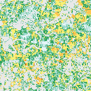
GrassLands - Mowing Frequency - Yearly, 10m
Grassland mowing dynamics (i.e. the timing and frequency of mowing events) have a strong impact on grassland functions and yields. As grasslands in Germany are managed on small-scale units and grass grows back quickly, satellite information with high spatial and temporal resolution is necessary to capture grassland mowing dynamics. Based on Sentinel-2 data time series, mowing events are detected throughout Germany and annual maps of the grassland mowing frequency generated. The grassland mowing detection approach operates per pixel, including preprocessing of the Enhanced Vegetation Index (EVI) time series and a calibrated rule-based grassland mowing detection which is specified in more detail in Reinermann et al. 2022, 2023.
INSPIRE
Identification
- File identifier
- 242a4f00-c6bf-4d53-a2ec-fd20a2895b7b XML
- Hierarchy level
- Series
Online resource
- Protocol
-
OGC:WMS
- Protocol
-
WWW:LINK-1.0-http--link
- Protocol
-
WWW:LINK-1.0-http--link
- Protocol
-
WWW:LINK-1.0-http--link
Resource identifier
- Metadata language
- English
- Spatial representation type
- Grid
Encoding
- Format
-
GeoTIFF
Projection
- code
- EPSG:4326
Classification of data and services
- Topic category
-
- Farming
Classification of data and services
Coupled resource
Coupled resource
Classification of data and services
Coupled resource
Coupled resource
Keywords
-
GEMET - INSPIRE themes, version 1.0
-
-
Land use
-
Other keywords
- Keywords
-
-
DLR
-
EOC
-
Germany
-
Agriculture
-
Mowing
-
Cutting
-
meadow
-
grassland management
-
Sentinel-2
-
opendata
-
Geographic coverage
))
Temporal reference
Temporal extent
- Begin
- 2018-01-01T00:00:00Z
Temporal extent
- Date (Creation)
- 2025-04-15
Quality and validity
- Lineage
-
All available Sentinel-2 data of the respective year for the whole of Germany are used.
- Denominator
- 20000
Conformity
Conformity
Conformity
Conformity
Conformity
Conformity
- Explanation
-
See the referenced specification.
Restrictions on access and use
- Access constraints
- Es gelten keine Zugriffsbeschränkungen
- Access constraints
-
Nutzungsbedingungen: Lizenz, https://creativecommons.org/licenses/by/4.0 / Terms of use: License, https://creativecommons.org/licenses/by/4.0
- Access constraints
-
{"id": "cc-by-4.0",
"name": "Creative Commons Namensnennung - 4.0 International (CC BY 4.0)",
"url": " http://dcat-ap.de/def/licenses/cc-by/4.0 ",
"quelle": "Copyright DLR (year of production)"}
Responsible organization (s)
Contact for the resource
- Organisation name
-
German Aerospace Center (DLR)
- Organisation name
-
German Aerospace Center (DLR)
Responsible organization (s)
Contact for the resource
- Organisation name
-
German Aerospace Center (DLR)
- Organisation name
-
German Aerospace Center (DLR)
Metadata information
Contact for the metadata
- Organisation name
-
German Aerospace Center (DLR)
- Date stamp
- 2025-04-15T09:41:48
- Metadata language
- English
- Character set
- UTF8
SDS
Conformance class 1: invocable
Access Point URL
Endpoint URL
Technical specification
Conformance class 2: interoperable
Access constraints
Limitation
Use constraints
Limitation
Responsible custodian
Contact for the resource
Overviews

Spatial extent
Provided by
