 My GeoNetwork catalogue
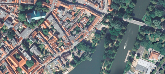
Digitales Orthophoto (DOP20) 32474-6082
Das digitale Orthophoto 32474-6082 wurde am 2024-07-05 aufgenommen. Die Bodenauflösung beträgt 20 cm. Die Ausprägung der Spektralkanäle ist RGBI, die Farbtiefe beträgt 8 Bit je Kanal. Die voraussichtlich nächste Befliegung für diese Kachel ist im Jahr 2026 geplant. Digitale Orthophotos sind für Schleswig-Holstein flächendeckend verfügbar. Unter der Bezeichnung historische DOPs sind ältere Ausgaben der aktuellen DOPs teilweise auch als schwarzweiß erhältlich.
INSPIRE
Identification
- File identifier
- 29345faf-0c8e-4e75-add8-be1c2ee28952 XML
- Hierarchy level
- Tile
Online resource
Resource identifier
- Metadata language
- Deutsch
- Spatial representation type
- Grid
Encoding
- Format
-
GeoTIFF, analog als Plot (großformatiger Ausdruck)
- Version
-
keine Angabe
Projection
- code
- EPSG:25832
Classification of data and services
- Topic category
-
- Imagery base maps earth cover
Classification of data and services
Coupled resource
Coupled resource
Classification of data and services
Coupled resource
Coupled resource
Keywords
Other keywords
- Keywords
-
-
Geobasisdaten
-
DOP
-
DOP20
-
Digitale Orthophotos
-
Digitale Orthofotos
-
opendata
-
Geographic coverage
))
Temporal reference
Temporal extent
Temporal extent
- Date (Creation)
- 2024-07-05
- Date (Publication)
- 2024-07-05
- Date (Revision)
- 2024-07-05
Quality and validity
- Lineage
-
Der Datensatz basiert auf Luftbildern, die bei der Ersterstellung fotogrammetrisch ausgewertet werden.
- Distance
- 20 cm
Conformity
Conformity
Conformity
Conformity
Conformity
Conformity
Restrictions on access and use
- Access constraints
- Es gelten keine Zugriffsbeschränkungen
- Access constraints
-
Für die Nutzung der Daten ist die Creative Commons (CC BY 4.0) – Namensnennung 4.0 International anzuwenden. Die Lizenz ist über http://creativecommons.org/licenses/by/4.0 abrufbar. Der Quellenvermerk lautet "© GeoBasis-DE/LVermGeo SH/CC BY 4.0"
- Access constraints
-
{"id":"cc-by/4.0","name":"Creative Commons Namensnennung – 4.0 International (CC BY 4.0)","url":" http://creativecommons.org/licenses/by/4.0/","quelle":"© GeoBasis-DE/LVermGeo SH/CC BY 4.0"}
Responsible organization (s)
Contact for the resource
- Organisation name
-
Landesamt für Vermessung und Geoinformation Schleswig-Holstein
Responsible organization (s)
Contact for the resource
- Organisation name
-
Landesamt für Vermessung und Geoinformation Schleswig-Holstein
Metadata information
Contact for the metadata
- Organisation name
-
Landesamt für Vermessung und Geoinformation Schleswig-Holstein
- Date stamp
- 2026-04-10
- Metadata language
- Deutsch
- Character set
- UTF8
SDS
Conformance class 1: invocable
Access Point URL
Endpoint URL
Technical specification
Conformance class 2: interoperable
Access constraints
Limitation
Use constraints
Limitation
Responsible custodian
Contact for the resource
Overviews
Spatial extent
Provided by
