 My GeoNetwork catalogue
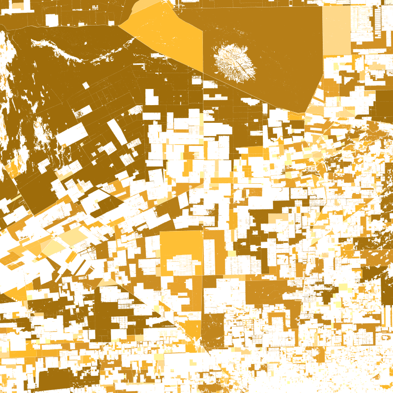
Geo-ForPy - Fragmentation of Forest Cover in the Paraguayan Chaco - Landsat-5/7/8, 2000/2010/2020
This product is a shape file of all detected forest patches in the Paraguayan Chaco that are larger than 10 hectars fort he years 2000, 2010, and 2020. Every forest patch contains information on its perimeter, size, shape, and core area. By looking at all forest patches together, an impression can be gained of the fragmentation of the forest in the Paraguayan Chaco.
Proximity is a measure of fragmentation. Areas of large and close by forest patches show high proximity values while isolated patches or patchest hat are only surrounded by small forest patches, have a small proximity.
The Core area index quantifies the share of core area in the entire forest patch area. Thereby, corea area is the area of a forest patch with at least 500m distance to the edge of the forest.
The Shape index is calculated from perimeter and area of a patch. The fragementation of a forest often has the effect that the ratio between area and perimeter is affected. The edge lengths become longer while the surface area becomes smaller.
INSPIRE
Identification
- File identifier
- 2F5ca620b7-1b15-47e5-af23-fc7ae77db345 XML
- Hierarchy level
- Dataset
Online resource
- Protocol
-
OGC:WMS
- Protocol
-
OGC:WMS
- Protocol
-
OGC:WMS
- Protocol
-
WWW:LINK-1.0-http--link
- Protocol
-
WWW:LINK-1.0-http--link
- Protocol
-
WWW:LINK-1.0-http--link
Resource identifier
- Metadata language
- English
- Spatial representation type
- Vector
Encoding
- Format
-
Geopackage
Projection
Classification of data and services
- Topic category
-
- Biota
Classification of data and services
Coupled resource
Coupled resource
Classification of data and services
Coupled resource
Coupled resource
Keywords
-
GEMET - INSPIRE themes, version 1.0
-
-
Land cover
-
Other keywords
- Keywords
-
-
opendata
-
forest
-
forest cover
-
random forest
-
fragmentation
-
Landsat-5
-
Landsat-7
-
Landsat-8
-
Paraguay
-
Geographic coverage
))
Temporal reference
Temporal extent
- Begin
- 2000-01-01T00:00:00
- End
- 2020-12-31T23:59:59
Temporal extent
- Date (Creation)
- 2022-09-01T00:00:00
Quality and validity
- Lineage
-
This data set provides information on the forest of the Paraguayan Chaco on a patch level, for the years 2000, 2010, and 2020.
- Denominator
- 60000
Conformity
Conformity
Conformity
Conformity
Conformity
Conformity
- Explanation
-
See the referenced specification.
Restrictions on access and use
- Access constraints
- There are no limitations on public access to spatial data sets and services.
- Access constraints
-
Nutzungsbedingungen: Lizenz, https://creativecommons.org/licenses/by/4.0/ Terms of use: License, https://creativecommons.org/licenses/by/4.0/
- Access constraints
-
{"id": "cc-by-4.0",
"name": "Creative-Commons - Attribution 4.0 International (CC BY 4.0)",
"url": " http://dcat-ap.de/def/licenses/cc-by/4.0 ",
"quelle": "Copyright DLR (2022)"}
Responsible organization (s)
Contact for the resource
- Organisation name
-
German Aerospace Center (DLR)
- Organisation name
-
German Aerospace Center (DLR)
Responsible organization (s)
Contact for the resource
- Organisation name
-
German Aerospace Center (DLR)
- Organisation name
-
German Aerospace Center (DLR)
Metadata information
Contact for the metadata
- Organisation name
-
German Aerospace Center (DLR)
- Date stamp
- 2024-06-20T13:06:54
- Metadata language
- English
- Character set
- UTF8
SDS
Conformance class 1: invocable
Access Point URL
Endpoint URL
Technical specification
Conformance class 2: interoperable
Access constraints
Limitation
Use constraints
Limitation
Responsible custodian
Contact for the resource
Overviews

Spatial extent
Provided by
