 My GeoNetwork catalogue
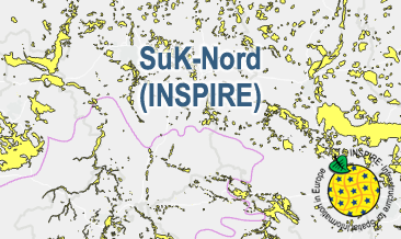
INSPIRE: Map of the distribution of sand and gravel in the Northern German glacial area
The SuK-Nord (INSPIRE) shows the geological distribution of aggregates (sand and gravel) in Northern Germany, especially north of the southernmost maximum of the Scandinavian inland ice sheet (Saalian and Elsterian glaciation). According to the Data Specifications on Mineral Resources (D2.8.III.21) and Geology (D2.8.II.4_v3.0) the content of the map is stored in two INSPIRE-compliant GML files: SuK_Nord_EarthResource_polygon.gml contains the distribution of aggreagtes (sand and gravel) as polygons. SuK_Nord_GeomorphologicFeature.gml contains the southernmost maximum of the Scandinavian inland ice sheet (Saalian and Elsterian glaciation) as lines. The GML files together with a Readme.txt file are provided in ZIP format (SuK_Nord-INSPIRE.zip). The Readme.text file (German/English) contains detailed information on the GML files content. Data transformation was proceeded by using the INSPIRE Solution Pack for FME according to the INSPIRE requirements.
INSPIRE
Identification
- File identifier
- 2ca5db23-8292-409f-bfc9-e753d113b588 XML
- Hierarchy level
- Dataset
Online resource
Resource identifier
- Metadata language
- English
- Spatial representation type
- Vector
Encoding
- Format
-
INSPIRE-GML
- Version
-
n/a
Projection
- code
- EPSG:25832
Classification of data and services
- Topic category
-
- Geoscientific information
- Economy
Classification of data and services
Coupled resource
Coupled resource
Classification of data and services
Coupled resource
Coupled resource
Keywords
-
GEMET - INSPIRE themes, version 1.0
-
-
Mineralische Bodenschätze
-
Mineral resources
-
Geologie
-
Geology
-
-
Spatial scope
-
-
Regional
-
-
High-value dataset categories
-
-
Erdbeobachtung und Umwelt
-
Other keywords
- Theme
-
-
inspireidentifiziert
-
opendata
-
gravel
-
sand
-
occurrence
-
- Place
-
-
Norddeutschland
-
Northern Germany
-
Geographic coverage
))
Temporal reference
Temporal extent
Temporal extent
- Date (Publication)
- 2023-10-19
Quality and validity
- Lineage
-
The SuK-Nord (INSPIRE GML files are based on the spatial dataset of the Map of the distribution of sand and gravel in the Northern German glacial area (SuK-Nord) transformed according to INSPIRE.
Conformity
Conformity
Conformity
Conformity
Conformity
Conformity
- Explanation
-
See the referenced specification
- Explanation
-
See the referenced specification
Restrictions on access and use
- Access constraints
- Es gelten keine Zugriffsbeschränkungen
- Access constraints
-
Dieser Datensatz kann gemäß der "Nutzungsbestimmungen für die Bereitstellung von Geodaten des Bundes" ( https://sg.geodatenzentrum.de/web_public/gdz/lizenz/geonutzv.pdf ) genutzt werden.
- Access constraints
-
{"id": "geoNutz/20130319", "name": "Nutzungsbestimmungen für die Bereitstellung von Geodaten des Bundes", "url": " https://sg.geodatenzentrum.de/web_public/gdz/lizenz/geonutzv.pdf ", "quelle": "Bundesanstalt für Geowissenschaften und Rohstoffe (BGR)"}
Responsible organization (s)
Contact for the resource
- Organisation name
-
Bundesanstalt für Geowissenschaften und Rohstoffe (BGR)
Responsible organization (s)
Contact for the resource
- Organisation name
-
Bundesanstalt für Geowissenschaften und Rohstoffe (BGR)
Metadata information
Contact for the metadata
- Organisation name
-
Bundesanstalt für Geowissenschaften und Rohstoffe (BGR)
- Date stamp
- 2025-04-23
- Metadata language
- English
- Character set
- UTF8
SDS
Conformance class 1: invocable
Access Point URL
Endpoint URL
Technical specification
Conformance class 2: interoperable
Access constraints
Limitation
Use constraints
Limitation
Responsible custodian
Contact for the resource
Overviews
Spatial extent
Provided by
