 My GeoNetwork catalogue
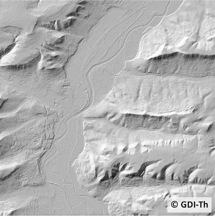
Digitales Geländemodell 25
Digitale Geländemodelle (DGM) beschreiben das Relief der Erdoberfläche durch ein regelmäßiges oder unregelmäßiges Punktraster, wobei für jeden Rasterpunkt die Lage und die Höhe bekannt sind. Es wird zwischen verschiedenen DGM je nach Höhengenauigkeit und Rasterweite unterschieden.
INSPIRE
Identification
- File identifier
- 2ebce934-5b10-4741-aab9-81f094763f8e XML
- Hierarchy level
- Dataset
Online resource
- Protocol
-
WWW:LINK-1.0-http--link
- Protocol
-
WWW:LINK-1.0-http--link
- Protocol
-
OGC:WMS-http-get-map
- Protocol
-
WWW:DOWNLOAD-1.0-http--download
Resource identifier
- Metadata language
- Deutsch
Encoding
- Format
-
Koordinatentripel (Rechtswert, Hochwert, Höhe)
- Version
-
ASCII-Format
Projection
- code
-
EPSG:25832
Classification of data and services
- Topic category
-
- Elevation
Classification of data and services
Coupled resource
Coupled resource
Classification of data and services
Coupled resource
Coupled resource
Keywords
-
GEMET - INSPIRE themes, version 1.0
-
-
Höhe
-
Other keywords
- Keywords
-
-
Luftbild
-
entzerren
-
Gelände
-
Orthophoto
-
GOVE
-
Modell
-
AdVMIS
-
Airborne
-
Laserscanning
-
LIDAR
-
opendata
-
Geographic coverage
))
Temporal reference
Temporal extent
Temporal extent
- Date (Creation)
- 1996-01-01
Quality and validity
- Lineage
-
Im TLVermGeo wird seit 1996 zur Erfassung das Verfahren des Airborne Laserscanning eingesetzt.
- Distance
- 2 m
Conformity
Conformity
Conformity
Conformity
Conformity
Conformity
Restrictions on access and use
- Access constraints
- Es gelten keine Zugriffsbeschränkungen
- Access constraints
-
Es gelten die Lizenzbedingungen „Datenlizenz Deutschland - Namensnennung - Version 2.0“ bzw. „dl-de/by-2-0” ( https://www.govdata.de/dl-de/by-2-0 ) mit den dort geforderten Angaben zum Quellenvermerk. Als Rechteinhaber und Bereitsteller ist die Datenhaltende Stelle, sowie das Jahr des Datenbezugs in Klammern anzugeben. Beispiel für Quellenvermerk: GDI-Th (2021) Datenlizenz Deutschland - Namensnennung - Version 2.0 (www.govdata.de/dl-de/by-2-0).
- Access constraints
-
{
"id": "dl-by-de/2.0",
"name": "Datenlizenz Deutschland Namensnennung 2.0",
"url": " https://www.govdata.de/dl-de/by-2-0 ",
"quelle": "© GDI-Th"
}
Responsible organization (s)
Contact for the resource
- Organisation name
-
Thüringer Landesamt für Bodenmanagement und Geoinformation
Responsible organization (s)
Contact for the resource
- Organisation name
-
Thüringer Landesamt für Bodenmanagement und Geoinformation
Metadata information
Contact for the metadata
- Organisation name
-
Thüringer Landesamt für Bodenmanagement und Geoinformation
- Date stamp
- 2022-01-24T14:37:57
- Metadata language
- Deutsch
- Character set
- UTF8
SDS
Conformance class 1: invocable
Access Point URL
Endpoint URL
Technical specification
Conformance class 2: interoperable
Access constraints
Limitation
Use constraints
Limitation
Responsible custodian
Contact for the resource
Overviews
Spatial extent
Provided by
