 My GeoNetwork catalogue
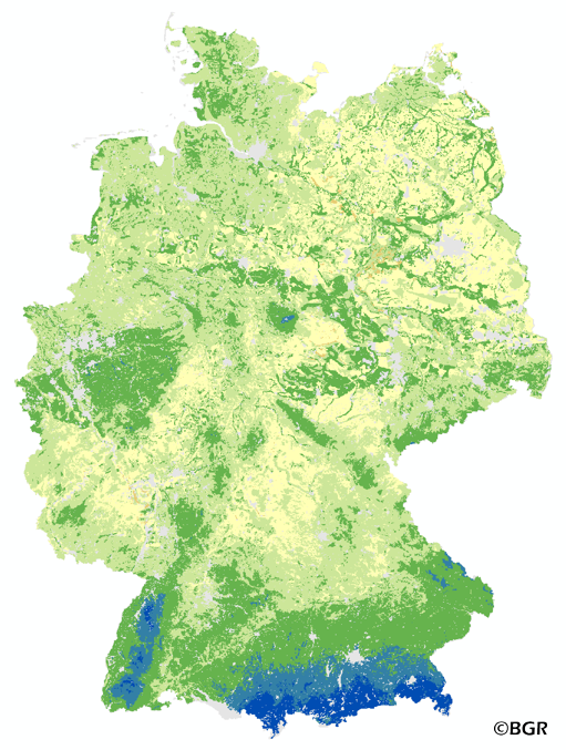
Plant available water in the summer half-year in Germany
The map of the plant available water in Germany gives an overview of the amount of water which is available for plant growth in the summer period (April – September). It is the sum of the available water holding capacity of soils the precipitation in summer and the amount of capillary rise. The map was made on the basis of the land use stratified soil map of Germany at a scale of 1:1,1000,000, climate data for the period of 1961–1990 and land use information is derived from the Corine Land Cover data set (2006). The method is part of the TUB_BGR approach to model seepage water and is published in the documentation of Ad-hoc-AG Boden (representing the soil experts of the geological services of the German federal states).
INSPIRE
Identification
- File identifier
- 2fbea264-465d-47f8-b3a0-3a406a02fec7 XML
- Hierarchy level
- Dataset
Online resource
Resource identifier
- code
-
6f6e3ff9-77f1-4e21-909d-3d9d8f6f0f94
- Metadata language
- Deutsch
- Spatial representation type
- Grid
Encoding
- Format
-
georef. TIFF
- Version
-
n/a
Projection
- code
- EPSG:3034
Classification of data and services
- Topic category
-
- Geoscientific information
Classification of data and services
Coupled resource
Coupled resource
Classification of data and services
Coupled resource
Coupled resource
Keywords
-
GEMET - INSPIRE themes, version 1.0
-
-
Boden
-
Soil
-
-
GEMET - Concepts, version 2.4
-
-
Bodenwasser
-
Bodenwasserhaushalt
-
Niederschlag
-
-
SGD-Liste
-
-
pflanzenverfügbares Bodenwasser
-
nutzbare Feldkapazität
-
-
Freies Schlagwort
-
-
Kapillarer Aufstieg
-
Other keywords
- Place
-
-
Bundesrepublik Deutschland
-
Geographic coverage
))
Temporal reference
Temporal extent
Temporal extent
- Date (Creation)
- 2014-06-20
- Date (Publication)
- 2015-08-03
Quality and validity
- Lineage
-
Bodendaten aus BÜK1000N V2.31 (BGR), Klimadaten des Deutschen Wetterdienstes (DWD). Landnutzungsdaten aus CORINE Land Cover 2006 (UBA/DLR).
- Denominator
- 1000000
Conformity
Conformity
Conformity
Conformity
Conformity
Conformity
- Explanation
-
siehe dazu die angegebene Durchführungsbestimmung
Restrictions on access and use
- Access constraints
- Es gelten keine Zugriffsbeschränkungen
- Access constraints
-
Allgemeine Geschäftsbedingungen, siehe https://www.bgr.bund.de/AGB - General terms and conditions, see https://www.bgr.bund.de/AGB_en . Die bereitgestellten Informationen sind bei Weiterverwendung wie folgt zu zitieren: Datenquelle: WVPFL1000_250 V1.0, (c) BGR, Hannover, 2014.
Responsible organization (s)
Contact for the resource
- Organisation name
-
Bundesanstalt für Geowissenschaften und Rohstoffe (BGR)
Responsible organization (s)
Contact for the resource
- Organisation name
-
Bundesanstalt für Geowissenschaften und Rohstoffe (BGR)
Metadata information
Contact for the metadata
- Organisation name
-
Bundesanstalt für Geowissenschaften und Rohstoffe (BGR)
- Date stamp
- 2023-08-22
- Metadata language
- Deutsch
- Character set
- UTF8
SDS
Conformance class 1: invocable
Access Point URL
Endpoint URL
Technical specification
Conformance class 2: interoperable
Access constraints
Limitation
Use constraints
Limitation
Responsible custodian
Contact for the resource
Overviews
Spatial extent
Provided by
