 My GeoNetwork catalogue
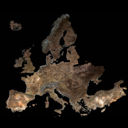
SoilSuite - Sentinel-2 - Europe, 5 year composite (2018-2022)
The SoilSuite contains a collection of different image data products that provide information about the spectral and statistical properties of European soils and other bare surfaces such as rocks. It is created using DLR's Soil Composite Mapping Processor (ScMAP), which utilises the Sentinel-2 data archive. SCMaP is a specialised processing chain for detecting and analysing bare soils/surfaces on a large (continental) scale. Bare surface and soil pixels are selected using a combined NDVI and NBR index (PVIR2) that optimises the exclusion of photosynthetically active and non-active vegetation. The index is calculated and applied for each individual pixel. All SoilSuite products are calculated based on the available Sentinel-2 scenes recorded between January 2018 and December 2022 in Europe. The data package excludes all scenes with a cloud cover of > 80 % and a sun elevation of < 20°. The spectral composite products are calculated from the mean value after extensive removal of clouds, haze and snow effects at both scene and pixel level. The spectral data products are available at a pixel size of 20 m and contain 10 Sentinel-2 bands (B02, B03, B04, B05, B06, B07, B08, B08a, B11, B12). The SoilSuite comprises: (a) “Bare Surface Reflectance Composite – Mean” that provides the spectral properties of soils that vary due to different soil organic carbon (SOC) content, soil moisture and soil minerology. This product is often used for spectral and digital soil mapping approaches, (b) “Bare Surface Reflectance Composite - Standard deviation” informing about the spectral dynamic of bare surfaces and soils, (c) “Bare Surface Reflectance Composite – 95% Confidence” contains information about the reliability of the spectral information due to the number of valid observations per pixel, (d) “Bare Surface Statistics Product” provides the number of bare soil occurrences over the total number of valid observations (Band 1), the number of bare soil occurrences (Band 2) and the total number of valid observations (Band 3), (e) “Mask” is a product that aggregates simple landcover classes that occur during the time period between 2018 - 2022 (Sentinel-2). The three-class Mask contains bare surface occurrences (1), permanent vegetation (2) and other surfaces such as water bodies, urban areas, roads (3). Additionally, the SoilSuite provides (f) “Reflectance Composite – Mean” that represents the mean reflectance of all valid Sentinel-2 observations between 2018 – 2022 including vegetation, bare and other surfaces, and (g) “Reflectance Composite – Standard deviation”, which contains the standard deviation per band for all valid Sentinel-2 observations between 2018 – 2022.
Simple
- Date (Creation)
- 2024-09-27T00:00:00
- Citation identifier
- https://geoservice.dlr.de/catalogue/srv/metadata/301c0949-d502-4a49-ba3d-cc7405240164
- Presentation form
- Digital map
- Other citation details
-
DOI: 10.15489/qkud8cudg596
- Status
- Completed
- Maintenance and update frequency
- As needed
- Keywords
-
-
DLR
-
EOC
-
Land
-
SCMaP
-
Soil
-
Sentinel-2
-
Europe
-
Temporal Composites
-
Soil Coverage
-
Soil Composite Mapping Processor
-
Reflectance Composite
-
Surface Reflectance Composite
-
Bare Soil Coverage
-
Bare Soil Frequency
-
opendata
-
-
GEMET - INSPIRE themes, version 1.0
-
-
Soil
-
- Use limitation
-
Nutzungseinschränkungen: Das DLR ist nicht haftbar für Schäden, die sich aus der Nutzung ergeben. / Use Limitations: DLR not liable for damage resulting from use.
- Use limitation
-
Nutzungsbedingungen: License, https://creativecommons.org/licenses/by/4.0/
- Access constraints
- Other restrictions
- Other constraints
-
License
- Use constraints
- License
- Use constraints
- Other restrictions
- Other constraints
-
Nutzungsbedingungen: License, https://creativecommons.org/licenses/by/4.0/
- Other constraints
-
{"id": "cc-by/4.0",
"name": "Creative Commons Namensnennung – 4.0 International (CC BY 4.0)",
"url": " http://dcat-ap.de/def/licenses/cc-by/4.0 ",
"quelle": "Copyright DLR (year of production)"}
- Spatial representation type
- Grid
- Denominator
- 40000
- Language
-
eng
- Character set
- UTF8
- Topic category
-
- Geoscientific information
))
- Begin date
- 2018-03-01T00:00:00
- End date
- 2022-12-31T23:59:59
- Reference system identifier
- EPSG / ETRS89 / LAEA Europe (EPSG:3035) / 8.6
- Number of dimensions
- 2
- Dimension name
- Column
- Dimension size
- 240000
- Resolution
- 20 m
- Dimension name
- Row
- Dimension size
- 220000
- Resolution
- 20 m
- Cell geometry
- Area
- Transformation parameter availability
- No
- Distribution format
-
- OnLine resource
-
Scientific publication
(
WWW:LINK-1.0-http--link
)
Scientific publication on the Soil Composite Mapping Processor (SCMaP)
- OnLine resource
-
Scientific publication
(
WWW:LINK-1.0-http--link
)
Scientific publication on Soil Reflectance Composites
- OnLine resource
-
Scientific publication
(
WWW:LINK-1.0-http--link
)
Scientific publication on continental bare surface reflectance composites
- OnLine resource
- EOC Download Service ( WWW:LINK-1.0-http--link )
- OnLine resource
- EOC STAC Collection ( WWW:LINK-1.0-http--link )
- OnLine resource
- https://geoservice.dlr.de/eoc/land/wms?SERVICE=WMS&REQUEST=GetCapabilities ( OGC:WMS-http-get-capabilities )
- OnLine resource
- EOC Geoservice Dataset ( WWW:LINK-1.0-http--link )
- OnLine resource
-
Data Description
(
WWW:LINK-1.0-http--link
)
SoilSuite Europe Data Description (pdf)
- OnLine resource
-
SOILSUITE_MASK_EUR_P5Y
(
OGC:WMS
)
SoilSuite – Mask, Europe
- OnLine resource
-
SOILSUITE_MREF-STD_EUR_P5Y
(
OGC:WMS
)
SoilSuite – Reflectance Composite – Standard deviation, Europe
- OnLine resource
-
SOILSUITE_MREF_EUR_P5Y
(
OGC:WMS
)
SoilSuite – Reflectance Composite, Mean - Europe
- OnLine resource
-
SOILSUITE_SFREQ-BSC_EUR_P5Y
(
OGC:WMS
)
SoilSuite – Bare surface count, Europe
- OnLine resource
-
SOILSUITE_SFREQ-BSF_EUR_P5Y
(
OGC:WMS
)
SoilSuite – Bare surface frequency, Europe
- OnLine resource
-
SOILSUITE_SFREQ-VPC_EUR_P5Y
(
OGC:WMS
)
SoilSuite – Valid pixel count, Europe
- OnLine resource
-
SOILSUITE_SRC-CI95_EUR_P5Y
(
OGC:WMS
)
SoilSuite – Bare Surface Reflectance Composite – 95% Confidence, Europe
- OnLine resource
-
SOILSUITE_SRC-STD_EUR_P5Y
(
OGC:WMS
)
SoilSuite – Bare Surface Reflectance Composite - Standard deviation, Europe
- OnLine resource
-
SOILSUITE_SRC_EUR_P5Y
(
OGC:WMS
)
SoilSuite – Bare Surface Reflectance Composite – Mean, Europe
- Hierarchy level
- Dataset
Domain consistency
- Measure identification
- INSPIRE / Conformity_001
Conformance result
- Date (Publication)
- 2010-12-08
- Explanation
-
See the referenced specification.
- Pass
- Yes
- Statement
-
As input data, all Sentinel-2 images from March 2018 to December 2022 over larger Europe in L1C data format are used. All scenes with a cloud cover of larger than 80 % and a sun elevation of lower than 20° were excluded.
- Description
-
The data has been transferred from L1C to L2A bottom of atmosphere reflectance (BOA) using the MAJA algorithm by considering the terrain correction. The resulting data stack is then reduced to 10 bands and resampled to 20 m pixel size using the bilinear resampling. For further information on the processing steps of the SoilSuite products, please see the linked publications.
- Description
-
SCMaP is a specialised processing chain for detecting and analysing bare soils/surfaces on a large (continental) scale. Bare surface and soil pixels are selected using a combined NDVI and NBR index (PVIR2) that optimises the exclusion of photosynthetically active and non-active vegetation. The index is calculated and applied for each individual pixel. The spectral composite products are calculated from the mean value after extensive removal of clouds, haze and snow effects at both scene and pixel level. The spectral data products are available at a pixel size of 20 m and contain 10 Sentinel-2 bands (B02, B03, B04, B05, B06, B07, B08, B08a, B11, B12).
- File identifier
- 301c0949-d502-4a49-ba3d-cc7405240164 XML
- Metadata language
- English
- Character set
- UTF8
- Hierarchy level
- Dataset
- Hierarchy level name
-
Dataset
- Date stamp
- 2025-10-16T09:07:16
- Metadata standard name
-
19115-1:2014/19139
- Metadata standard version
-
1.0
Overviews

Spatial extent
Provided by
