 My GeoNetwork catalogue
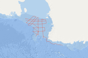
Processed seismic data of Cruise BGR80 1980
During the cruise with S.V. EXPLORA within the Ross Sea on the second marine-geophysical expedition of the Federal Institute for Geosciences and Natural Resources (BGR) to Antarctica, in total 6,745 km of magnetic, gravity and digital reflection seismic lines and additionally 1,400 km gravity lines were acquired in the period from January 10th to March 2nd 1980. On 43 stations sonobuoy refraction measurements have been carried out. The main results are: (1) In the eastern part of the Ross Sea Shelf two striking discontinuities have been identified in the reflection seismics representing gaps in the sediments at the turn-over of the Upper Miocene to the Pliocene (ca. 7 mio years B.P.) and between the Middle and Upper Miocene (ca. 11.5 mio. years B.P.) according to results of DSDP boreholes. (2) In the southern part of the Ross Sea Shelf the basement is uncovered at depths over 700m due to a thrust of the shelf ice recently. (3) A structural unit extends alongside the meridian of 180° separating the Ross Sea into two different geologic regions. This unit is characterised by two basement highs with seismic velocities exceeding 5 km/sec. (4) In relation with the GANOVEX expedition two profiles have been measured off northern Victoria Land which indicate two large faults with a faulting amount of 2 km. Another area is characterised by intrusive and volcanic bodies.
Simple
- Alternate title
-
BGR80 1980
- Date (Creation)
- 1980-03-02
- Citation identifier
- 68d180de-f9c6-242f-e8d8-716bba000a36
- Status
- Completed
-
GEMET - INSPIRE themes, version 1.0
-
-
Geologie
-
geology
-
-
GEMET - Concepts, version 2.4
-
-
geophysics
-
Geophysik
-
raw material
-
Rohstoff
-
- Theme
-
-
Marine geology
-
Meeresgeologie
-
Seismics
-
Seismik
-
Two-dimensional seismic reflection
-
zweidimensionale Reflektionsseismik
-
- Place
-
-
Ross Sea
-
Ross-Meer
-
- Access constraints
- Other restrictions
- Other constraints
- Es gelten keine Zugriffsbeschränkungen
- Use constraints
- Other restrictions
- Other constraints
-
Allgemeine Geschäftsbedingungen, siehe http://www.bgr.bund.de/AGB - General terms and conditions, see http://www.bgr.bund.de/AGB_en . Die bereitgestellten Informationen sind bei Weiterverwendung wie folgt zu zitieren: Datenquelle: BGR80 1980, (c) BGR, Hannover, 2019
- Spatial representation type
- Vector
- Language
- English
- Character set
- UTF8
- Topic category
-
- Geoscientific information
))
- Unique resource identifier
- EPSG:4326
- Distribution format
-
-
Shapefile
(
n/a
)
-
Shapefile
(
n/a
)
- Transfer size
- 2
- OnLine resource
-
BGR80 1980 (Shapefile)
BGR80 1980 im Format ESRI Shape
- OnLine resource
- Profile BGR80-001
- OnLine resource
- Profile BGR80-002
- OnLine resource
- Profile BGR80-003
- OnLine resource
- Profile BGR80-004
- OnLine resource
- Profile BGR80-007A
- OnLine resource
- Profile BGR80-007B
- OnLine resource
- Profile BGR80-008A
- OnLine resource
- Profile BGR80-008B
- OnLine resource
- Profile BGR80-009
- OnLine resource
- Profile BGR80-010
- OnLine resource
- Profile BGR80-011
- OnLine resource
- Profile BGR80-100
- OnLine resource
- Profile BGR80-101
- OnLine resource
- Profile BGR80-102
- OnLine resource
- Profile BGR80-103
- OnLine resource
- Profile BGR80-104
- OnLine resource
- Profile BGR80-105
- OnLine resource
- Profile BGR80-106
- OnLine resource
- Profile BGR80-107
- OnLine resource
- Profile BGR80-108
- OnLine resource
- Profile BGR80-109
- OnLine resource
- Profile BGR80-110
- OnLine resource
- Karte im BGR-Geoviewer
- Hierarchy level
- Dataset
Conformance result
- Date (Publication)
- 2010-12-08
- Explanation
-
siehe dazu die angegebene Durchführungsbestimmung
- Statement
-
During the period from 10th January to 2nd March 1980 BGR acquired seismic lines in the Ross Sea. The lines BGR80-005 and BGR80-006 consist of raw data. The lines BGR80-001, BGR80-002, BGR80-003, BGR80-004, BGR80-007A, BGR80-007B, BGR80-008A, BGR80-008B, BGR80-009, BGR80-010, BGR80-011, BGR80-100, BGR80-101, BGR80-102, BGR80-103, BGR80-104, BGR80-105, BGR80-106, BGR80-107, BGR80-108, BGR80-109 and BGR80-110 are stacked data.
- File identifier
- 30b5e4d5-661b-4837-9126-26d0c312a69f XML
- Metadata language
- English
- Character set
- UTF8
- Parent identifier
-
Marine Seismic Survey Profiles (MSSP)
06a73c56-06a2-40d8-b806-466222b0760d
- Hierarchy level
- Dataset
- Hierarchy level name
-
Geophysik
- Date stamp
- 2023-11-14
- Metadata standard name
-
INSPIRE Metadata Implementing Rules: Technical Guidelines based on EN ISO 19115 and EN ISO 19119
- Metadata standard version
-
n/a
Overviews
Spatial extent
Provided by
