 My GeoNetwork catalogue
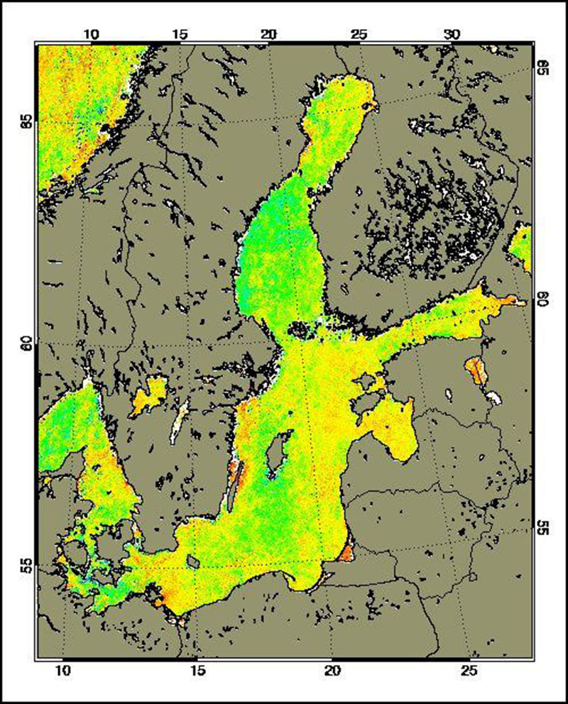
MERIS - Water Parameters - Baltic Sea, Daily
The Medium Resolution Imaging Spectrometer (MERIS) on Board ESA’s ENVISAT provides spectral high resolution image data in the visible-near infrared spectral region (412-900 nm) at a spatial resolution of 300 m. For more details on ENVISAT and MERIS see http://envisat.esa.int/
Spectral high resolution measurements allow to assess different water constituents in optically complex case-2 waters (IOCCG, 2000). The main groups of constituents are Chlorophyll, corresponding to living phytoplankton, suspended minerals or sediments and dissolved organic matter. They are characterised by their specific inherent optical properties, in particular scattering and absorption spectra.
The Baltic Sea Water Constituents product was developed in a co-operative effort of DLR (Remote Sensing Technology Institute IMF, German Remote Sensing Data Centre DFD), Brockmann Consult (BC) and Baltic Sea Research Institute (IOW) in the frame of the MAPP project (MERIS Application and Regional Products Projects). The data are processed on a regular (daily) basis using ESA standard Level-1 and -2 data as input and producing regional specific value added Level-3 products. The regular data reception is realised at DFD ground station in Neustrelitz.
For more details the reader is referred to
http://wdc.dlr.de/sensors/meris/ and http://wdc.dlr.de/sensors/meris/documents/Mapp_ATBD_final_i3r0dez2001.pdf
This product provides daily maps.
- Identification
- Distribution
- Quality
- Spatial rep.
- Ref. system
- Content
- Portrayal
- Metadata
- Md. constraints
- Md. maintenance
- Schema info
Identification
Data identification
Citation
- Date (Creation)
- 2015-08-01T00:00:00
- Citation identifier
- https://geoservice.dlr.de/catalogue/srv/metadata/319691c5-0322-458c-80d3-c2d60cfbb86c
- Presentation form
- Digital map
- Status
- Completed
- Maintenance and update frequency
- Not planned
-
GEMET - INSPIRE themes, version 1.0
-
-
Oceanographic geographical features
-
- Keywords
-
-
ENVISAT
-
MERIS
-
Baltic Sea
-
Water parameter
-
daily
-
urn:eop:DLR:EOWEB:Water_Parameter_Baltic_Sea_MERIS_daily_maps
-
FEDEO
-
Legal constraints
- Access constraints
- License
- Use constraints
- Other restrictions
- Other constraints
-
Nutzungsbedingungen: CC BY-SA 'Attribution ShareAlike' https://creativecommons.org/licenses/by-sa/4.0/legalcode
Reference for the use of MERIS products in publications: Products generated by DLR-DFD
- Use limitation
-
Nutzungseinschränkungen: DLR not liable for damage resulting from use
- Spatial representation type
- Grid
- Denominator
- 600000
- Language
- English
- Character set
- UTF8
- Topic category
-
- Oceans
Extent
))
- Begin date
- 2006-01-01T08:00:16
- End date
- 2012-04-08T11:06:13
Distribution
Distribution
- Distribution format
-
- OnLine resource
-
MERIS - Water Parameters - Baltic Sea, Daily
(
WWW:LINK-1.0-http--link
)
EOWEB GeoPortal Collection
Quality
Data quality
- Hierarchy level
- Series
Domain consistency
- Measure identification
- INSPIRE / Conformity_001
Conformance result
Citation
- Date (Publication)
- 2010-12-08
- Explanation
-
See the referenced specification
- Pass
- Yes
Lineage
- Statement
-
For further information see: http://wdc.dlr.de/sensors/meris/ and http://wdc.dlr.de/sensors/meris/documents/Mapp_ATBD_final_i3r0dez2001.pdf
Ref. system
- Reference system identifier
- EPSG / ETRS89 / LAEA Europe (EPSG:3035) / 8.6
Metadata
Metadata
- File identifier
- 319691c5-0322-458c-80d3-c2d60cfbb86c XML
- Metadata language
- English
- Character set
- UTF8
- Hierarchy level
- Series
- Hierarchy level name
-
Dataseries
- Date stamp
- 2024-09-27T14:12:03
- Metadata standard name
-
ISO 19115-1:2014/19139
- Metadata standard version
-
1.0
Overviews
Spatial extent
Provided by
