 My GeoNetwork catalogue
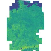
Sentinel-2 - Vegetation Index (NDVI) - Germany, 2015
This dataset includes the normalized difference vegetation index (NDVI) derived from Sentinel-2 imagery. Using the Google Earth Engine, all granules with a cloud cover below 60% were used as input. Cloudy pixels (referring to quality layer QA60) were masked as well. Eventually, a median mosaic was composed over the whole observation period. It was also used as input for a land cover classification (see: Land Cover DE - Sentinel-2 - Germany, 2015).
- Identification
- Distribution
- Quality
- Spatial rep.
- Ref. system
- Content
- Portrayal
- Metadata
- Md. constraints
- Md. maintenance
- Schema info
Identification
Data identification
Citation
- Date (Creation)
- 2023-03-17T12:48:00
- Edition
-
1.0
- Citation identifier
- https://geoservice.dlr.de/catalogue/srv/metadata/33debbeb-3b97-4d5c-8fb7-9de76f5736bf
- Presentation form
- Digital map
- Other citation details
-
DOI: 10.15489/z5rq0pr8wv85
- Status
- Completed
- Maintenance and update frequency
- As needed
-
GEMET - INSPIRE themes, version 1.0
-
-
Land cover
-
- Keywords
-
-
Sentinel-2
-
Land cover
-
Vegetation
-
Greenness
-
Health
-
Urban Heat Islands
-
Germany
-
- Use limitation
-
Nutzungseinschränkungen: Das DLR ist nicht haftbar für Schäden, die sich aus der Nutzung ergeben. / Use Limitations: DLR not liable for damage resulting from use.
- Use limitation
-
Nutzungsbedingungen: Lizenz, https://creativecommons.org/licenses/by-nc/4.0 / Terms of use: License, https://creativecommons.org/licenses/by-nc/4.0
Legal constraints
- Access constraints
- Other restrictions
- Other constraints
-
License
Legal constraints
- Use constraints
- License
- Use constraints
- Other restrictions
- Other constraints
-
Nutzungsbedingungen: Lizenz, https://creativecommons.org/licenses/by-nc/4.0 / Terms of use: License, https://creativecommons.org/licenses/by-nc/4.0
- Other constraints
-
{"id": "cc-by-nc/4.0",
"name": "Creative Commons Namensnennung - Nicht kommerziell 4.0 International (CC BY-NC 4.0)",
"url": " http://dcat-ap.de/def/licenses/cc-by-nc/4.0 ",
"quelle": "Copyright DLR (year of production)"}
- Spatial representation type
- Grid
- Denominator
- 20000
- Language
- English
- Character set
- UTF8
- Topic category
-
- Imagery base maps earth cover
Extent
))
- Begin date
- 2015-06-27T10:25:31
- End date
- 2017-09-29T10:20:07
Distribution
Distribution
- Distribution format
-
-
GeoTIFF
()
-
GeoTIFF
()
Digital transfer options
- OnLine resource
-
HTTP Download
(
WWW:LINK-1.0-http--link
)
HTTP Download (Noise2Nako NDVI)
- OnLine resource
-
EOC Geoservice Map Context
(
WWW:LINK-1.0-http--link
)
EOC Geoservice Map Context (de:lcc)
- OnLine resource
-
Noise2NAKO(AI) project website
(
WWW:LINK-1.0-http--link
)
Website of the Noise2NAKO(AI) project
Quality
Data quality
- Hierarchy level
- Dataset
Domain consistency
- Measure identification
- INSPIRE / Conformity_001
Conformance result
Citation
- Date (Publication)
- 2010-12-08
- Explanation
-
See the referenced specification.
- Pass
- Yes
- Statement
-
Input data: Sentinel-2 multispectral imagery
Spatial rep.
Grid spatial representation
- Number of dimensions
- 2
Dimension
- Dimension name
- Column
- Dimension size
- 65120
- Resolution
- 10 m
Dimension
- Dimension name
- Row
- Dimension size
- 87740
- Resolution
- 10 m
- Cell geometry
- Area
- Transformation parameter availability
- No
Ref. system
- Unique resource identifier
- EPSG:3035
Metadata
Metadata
- File identifier
- 33debbeb-3b97-4d5c-8fb7-9de76f5736bf XML
- Metadata language
- English
- Character set
- UTF8
- Hierarchy level
- Dataset
- Hierarchy level name
-
Dataset
- Date stamp
- 2024-11-11T08:36:42
- Metadata standard name
-
19115-1:2014/19139
- Metadata standard version
-
1.0
Overviews

Spatial extent
Provided by
