 My GeoNetwork catalogue
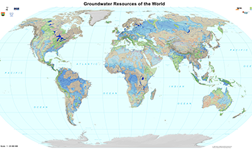
Groundwater Resources of the World (WHYMAP GWR) (WMS)
The World-wide Hydrogeological Mapping and Assessment Programme (WHYMAP) provides data and information about the earth´s major groundwater resources. The Groundwater Resources Map shows various characteristic groundwater environments in their areal extent and classified by their aquifer productivity and recharge potential. Additional groundwater related features such as wetlands and areas of low rainfall are included in the dataset.
INSPIRE
Identification
- File identifier
- 38c119fe-4acd-4a7f-a704-8e41656feb82 XML
- Hierarchy level
- Service
Online resource
Resource identifier
Encoding
- Format
-
png
- Version
-
n/a
- Format
-
jpeg
- Version
-
n/a
- Format
-
gif
- Version
-
n/a
Projection
- code
- EPSG:4326
Classification of data and services
- Service Type
- view
- Coupling Type
- Tight
Coupled resource
Coupled resource
Classification of data and services
- Service Type
- view
- Coupling Type
- Tight
Coupled resource
Coupled resource
Keywords
-
GEMET - INSPIRE themes, version 1.0
-
-
Geologie
-
Geology
-
-
GEMET - Concepts, version 2.4
-
-
Grundwasser
-
Hydrogeologie
-
Groundwater
-
Hydrogeology
-
Other keywords
- Theme
-
-
Aquifer
-
Grundwasserneubildung
-
Groundwater recharge
-
Grundwasservorkommen
-
Groundwater resources
-
Grundwasserentnahme
-
Groundwater abstraction
-
infoMapAccessService
-
- Place
-
-
Weltweit
-
World-wide
-
Geographic coverage
))
Temporal reference
Temporal extent
Temporal extent
- Date (Creation)
- 2016-02-10
Quality and validity
- Lineage
-
World-wide Hydrogeological Mapping and Assessment Programme (WHYMAP)
Conformity
Conformity
Conformity
Conformity
Conformity
Conformity
Restrictions on access and use
- Access constraints
- Es gelten keine Zugriffsbeschränkungen
- Access constraints
-
Allgemeine Geschäftsbedingungen, s.: https://www.bgr.bund.de/AGB - General terms and conditions, s. https://www.bgr.bund.de/AGB_en ; Die bereitgestellten Informationen sind bei Weiterverwendung wie folgt zu zitieren: Datenquelle: WHYMAP, (C) BGR Hannover & UNESCO Paris
Responsible organization (s)
Contact for the resource
- Organisation name
-
Bundesanstalt für Geowissenschaften und Rohstoffe (BGR)
- Organisation name
-
Bundesanstalt für Geowissenschaften und Rohstoffe (BGR)
Responsible organization (s)
Contact for the resource
- Organisation name
-
Bundesanstalt für Geowissenschaften und Rohstoffe (BGR)
- Organisation name
-
Bundesanstalt für Geowissenschaften und Rohstoffe (BGR)
Metadata information
Contact for the metadata
- Organisation name
-
Bundesanstalt für Geowissenschaften und Rohstoffe (BGR)
- Date stamp
- 2025-03-07
- Metadata language
- English
SDS
Conformance class 1: invocable
Access Point URL
Endpoint URL
Technical specification
- Date
- Explanation
-
siehe dazu die angegebene Durchführungsbestimmung
Conformance class 2: interoperable
Access constraints
- Access constraints
- Other restrictions
- Other constraints
- Es gelten keine Zugriffsbeschränkungen
Limitation
Use constraints
Limitation
- string
-
Allgemeine Geschäftsbedingungen, s.: https://www.bgr.bund.de/AGB - General terms and conditions, s. https://www.bgr.bund.de/AGB_en ; Die bereitgestellten Informationen sind bei Weiterverwendung wie folgt zu zitieren: Datenquelle: WHYMAP, (C) BGR Hannover & UNESCO Paris
Responsible custodian
Contact for the resource
- Organisation name
-
Bundesanstalt für Geowissenschaften und Rohstoffe (BGR)
Conformance class 3: harmonized
Contains Operations
- Operation Name
-
GetCapabilities
- Distributed Computing Platforms
- Web services
- Connect Point
- https://services.bgr.de/wms/grundwasser/whymap_gwr/?
Contains Operations
- Operation Name
-
GetMap
- Distributed Computing Platforms
- Web services
- Connect Point
- https://services.bgr.de/wms/grundwasser/whymap_gwr/?
Overviews
Spatial extent
Provided by
