 My GeoNetwork catalogue
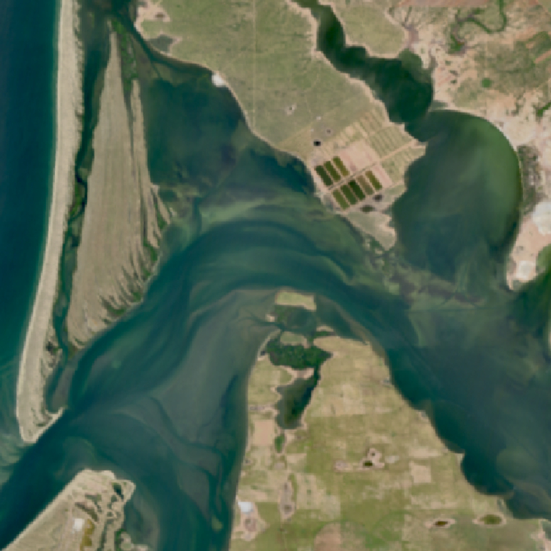
EnMAP HSI - Level 2A Hyperspectral Images - Global
The EnMAP HSI L2A dataset collection comprises a standardized, consistent, systematically processed, and cloud-native level-2A dataset series for the entire mission. It is especially useful for big data or time series analyses. The dataset is processed with the atmospheric correction over land processor and is provided in cloud-optimized GeoTIFF format for direct access and download. The metadata follows the CEOS Analysis Ready Data (CEOS-ARD) framework. The database is constantly updated with newly acquired data.
The Environmental Mapping and Analysis Program (EnMAP) is a German hyperspectral satellite mission that monitors and characterizes Earth’s environment on a global scale. EnMAP delivers accurate data that provides information on the status and evolution of terrestrial and aquatic ecosystems, supporting environmental monitoring, management, and decision-making.
For more information, please see the mission website: https://www.enmap.org/mission/
Simple
- Date (Creation)
- 2022-10-10T12:48:00
- Citation identifier
- https://geoservice.dlr.de/catalogue/srv/metadata/39e254f4-e192-43d4-a159-f3e4dab3ec37
- Presentation form
- Digital image
- Status
- ongoing
- Maintenance and update frequency
- Daily
-
GEMET - INSPIRE themes, version 1.0
-
-
Orthoimagery
-
- Keywords
-
-
DLR
-
EOC
-
EnMAP
-
HSI
-
Global
-
hyperspectral
-
Level 2A
-
- Use limitation
-
Nutzungseinschränkungen: Das DLR ist nicht haftbar für Schäden, die sich aus der Nutzung ergeben. / Use Limitations: DLR not liable for damage resulting from use.
- Access constraints
- Other restrictions
- Other constraints
- Öffentlicher Zugriff beschränkt entsprechend Artikel 13(1)(e) der INSPIRE-Richtlinie: e) aufgrund nachteiliger Auswirkungen auf die Rechte des geistigen Eigentums
- Use constraints
- Other restrictions
- Other constraints
-
Nutzungsbedingungen: Lizenz, https://geoservice.dlr.de/resources/licenses/enmap/EnMAP-Data_License.pdf / Terms of use: License, https://geoservice.dlr.de/resources/licenses/enmap/EnMAP-Data_License.pdf
- Other constraints
-
{"id": "other-closed",
"name": "Andere geschlossene Lizenz",
"url": " http://dcat-ap.de/def/licenses/other-closed ",
"quelle": "Data citation: EnMAP data ©DLR [year of acquisition] All rights reserved. Derivate products citation: Contains modified EnMAP data ©DLR [year of acquisition]."}
- Spatial representation type
- Grid
- Denominator
- 60000
- Language
- English
- Character set
- UTF8
- Topic category
-
- Imagery base maps earth cover
))
- Begin date
- 2022-04-27T00:00:00
- Unique resource identifier
- EPSG:4326
- Distribution format
-
-
GeoTIFF
()
-
GeoTIFF
()
- OnLine resource
- HTTP download EnMAP HSI - Level 2A - Hyperspectral Images - Global ( WWW:LINK-1.0-http--link )
- OnLine resource
-
ENMAP.HSI.L0
(
WWW:LINK-1.0-http--link
)
EOWEB GeoPortal
- OnLine resource
-
EnMAP mission website
(
WWW:LINK-1.0-http--link
)
Website of the EnMAP mission (html)
- OnLine resource
- EOC STAC Collection ( WWW:LINK-1.0-http--link )
- Hierarchy level
- Series
Domain consistency
- Measure identification
- INSPIRE / Conformity_001
Conformance result
- Date (Publication)
- 2010-12-08
- Explanation
-
See the referenced specification.
- Pass
- Yes
- Statement
-
Input data: EnMAP HSI Level 1C satellite data
- Description
-
For an overview of the EnMAP processing chain, please see the following link: https://www.enmap.org/data/doc/EN-PCV-TN-6007_Level_2A_Processor_Atmospheric_Correction_Land.pdf and https://www.enmap.org/data/doc/EN-PCV-TN-6008_Level_2A_Processor_Atmospheric_Correction_Water.pdf
- File identifier
- 39e254f4-e192-43d4-a159-f3e4dab3ec37 XML
- Metadata language
- English
- Character set
- UTF8
- Hierarchy level
- Series
- Hierarchy level name
-
Dataseries
- Date stamp
- 2024-08-12T07:07:02
- Metadata standard name
-
ISO 19115-1:2014/19139
- Metadata standard version
-
2003/Cor.1:2006
Overviews
Spatial extent
Provided by
