 My GeoNetwork catalogue
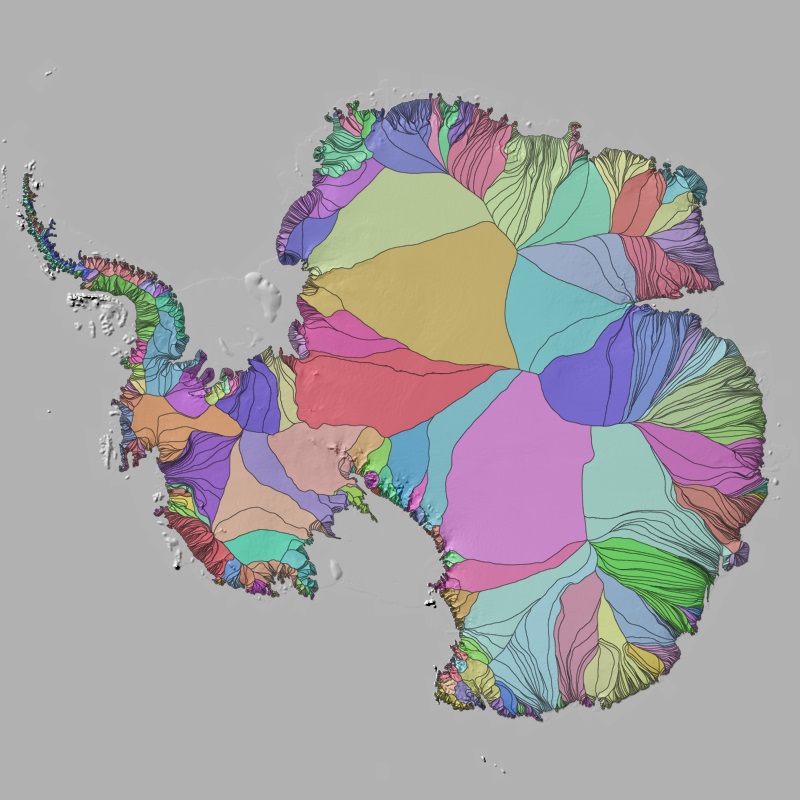
Polar Monitor - Ice sheet drainage basins - Antarctica, 2010-2021
The drainage divides of ice sheets separate the overall glaciated area into multiple sectors. These drainage basins are essential for partitioning mass changes of the ice sheet, as they specify the area over which basin specific measurements are integrated. In (Krieger et al., 2020) we developed a modified watershed algorithm for delineating individual glaciers and applied it to the Northeast Greenland sector. Here we extended the processing to the entire Antarctic Ice Sheet.
Simple
- Date (Creation)
- 2025-07-10T00:00:00
- Citation identifier
- https://geoservice.dlr.de/catalogue/srv/metadata/39fd6746-3e32-437c-9b8f-097326d62cf6
- Presentation form
- Digital map
- Other citation details
-
DOI: 10.15489/kel9qeeou202
- Purpose
-
Individual glacier catchments support a quantification of glacier changes for a specified region and are therefore an important tool in the field of glaciology and hydrology. The Antarctic drainage basins provide detailed information for partitioning mass changes of the ice sheet to the individual glacier or regional level.
- Status
- Completed
- Maintenance and update frequency
- As needed
-
GEMET - INSPIRE themes, version 1.0
-
-
Hydrography
-
- Keywords
-
-
DLR
-
EOC
-
Catchments
-
Drainage basins
-
Watershed
-
Glacier
-
Ice Sheet
-
Antarctica
-
opendata
-
- Use limitation
-
Nutzungseinschränkungen: Das DLR ist nicht haftbar für Schäden, die sich aus der Nutzung ergeben. / Use Limitations: DLR not liable for damage resulting from use.
- Access constraints
- Other restrictions
- Use constraints
- Other restrictions
- Other constraints
-
Nutzungsbedingungen: Lizenz, https://creativecommons.org/licenses/by/4.0/ Terms of use: License, https://creativecommons.org/licenses/by/4.0/
- Other constraints
-
{"id": "cc-by-4.0",
"name": "Creative-Commons - Attribution 4.0 International (CC BY 4.0)",
"url": " http://dcat-ap.de/def/licenses/cc-by/4.0 ",
"quelle": "Copyright DLR (2025)"}
- Spatial representation type
- Grid
- Denominator
- 1000000
- Language
- English
- Character set
- UTF8
))
- Begin date
- 2010-01-01T00:00:00
- End date
- 2021-12-31T23:59:59
- Unique resource identifier
- EPSG:3031
- Distribution format
-
-
geo+json
()
-
geopackage+sqlite3
()
-
vnd.shp
()
-
geo+json
()
- OnLine resource
- HTTP download Polar Monitor Antarctica ( WWW:LINK-1.0-http--link )
- OnLine resource
- Scientific Publication ( WWW:LINK-1.0-http--link )
- OnLine resource
- EOC Geoservice Dataset ( WWW:LINK-1.0-http--link )
- Hierarchy level
- Dataset
Domain consistency
- Measure identification
- INSPIRE / Conformity_001
Conformance result
- Date (Publication)
- 2010-12-08
- Explanation
-
See the referenced specification.
- Pass
- Yes
- Statement
-
Input data: In the modified watershed approach ice sheet wide velocity measurements by Sentinel-1 SAR (Nagler et al., 2015) and the 90 m TanDEM-X Polar DEM (Wessel et al., 2021) are combined to derive individual glacier drainage basins for the entire Antarctic Ice Sheet. The algorithm is seeded at the grounding line (Mouginot et al., 2017)
- Description
-
Originating from selected seed points at the grounding line we produced discrete stream lines based on the methodology of (Cabral et al., 1993) for all areas exceeding a threshold of 50 m/yr and followed these upstream. For slower areas a classical flood-filling watershed algorithm is adopted (Beucher et al., 1992). A Monte Carlo simulation was performed, repeating the catchment delineation procedure 5000 times to account for uncertainties. The final catchment label was then determined by selecting the label that emerged as the majority outcome across all simulations. For processing details please consult (Krieger et al., 2020).
The methodology has been validated in the Northeast Greenland sector by comparing the basin extent to existing delineations in the literature. Marginal discrepancies in catchment area arise for various reasons, including the choice of the DEM, the velocity dataset or the used methodology. As an independent, high accuracy data base for full validation of the results is lacking, quality assessment was supported by performing an intercomparsion with different input data combinations of DEMs and ice velocity products showing discrepancies of up to 16% in the extent of the catchment area. The quality of the presented results was further assessed by a probability measure from additional Monte-Carlo experiment.
- File identifier
- 39fd6746-3e32-437c-9b8f-097326d62cf6 XML
- Metadata language
- English
- Character set
- UTF8
- Hierarchy level
- Dataset
- Hierarchy level name
-
Dataset
- Date stamp
- 2025-11-27T16:28:10
- Metadata standard name
-
ISO 19115-1:2014/19139
Overviews

Spatial extent
Provided by
