 My GeoNetwork catalogue
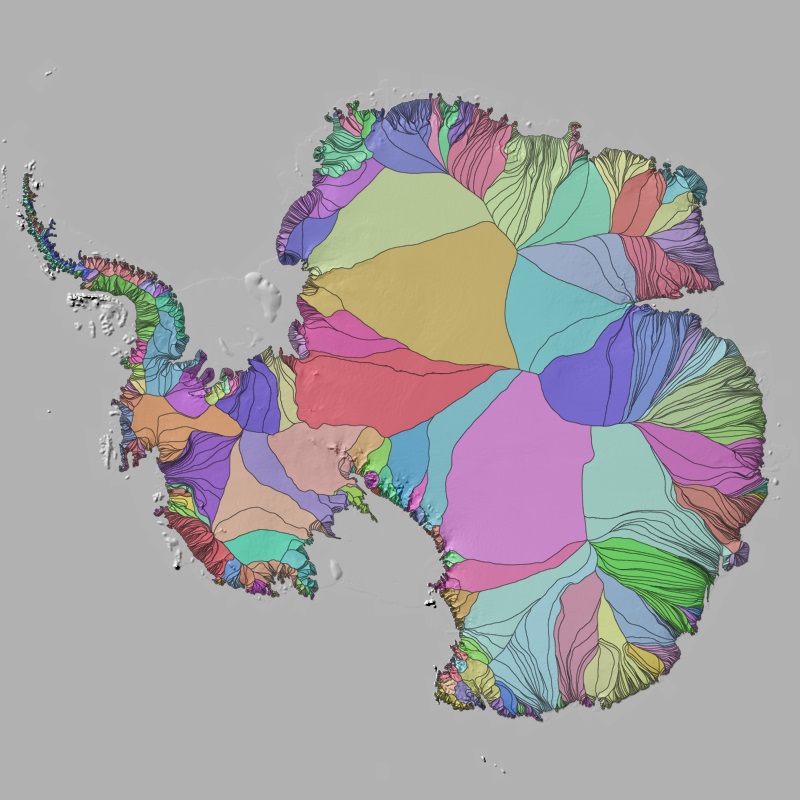
Polar Monitor - Ice sheet drainage basins - Antarctica, 2010-2021
The drainage divides of ice sheets separate the overall glaciated area into multiple sectors. These drainage basins are essential for partitioning mass changes of the ice sheet, as they specify the area over which basin specific measurements are integrated. In (Krieger et al., 2020) we developed a modified watershed algorithm for delineating individual glaciers and applied it to the Northeast Greenland sector. Here we extended the processing to the entire Antarctic Ice Sheet.
INSPIRE
Identification
- File identifier
- 39fd6746-3e32-437c-9b8f-097326d62cf6 XML
- Hierarchy level
- Dataset
Online resource
- Protocol
-
WWW:LINK-1.0-http--link
- Protocol
-
WWW:LINK-1.0-http--link
- Protocol
-
WWW:LINK-1.0-http--link
Resource identifier
- Metadata language
- English
- Spatial representation type
- Grid
Encoding
- Format
-
geo+json
- Format
-
geopackage+sqlite3
- Format
-
vnd.shp
Projection
- code
- EPSG:3031
Classification of data and services
Coupled resource
Coupled resource
Classification of data and services
Coupled resource
Coupled resource
Keywords
-
GEMET - INSPIRE themes, version 1.0
-
-
Hydrography
-
Other keywords
- Keywords
-
-
DLR
-
EOC
-
Catchments
-
Drainage basins
-
Watershed
-
Glacier
-
Ice Sheet
-
Antarctica
-
opendata
-
Geographic coverage
))
Temporal reference
Temporal extent
- Begin
- 2010-01-01T00:00:00
- End
- 2021-12-31T23:59:59
Temporal extent
- Date (Creation)
- 2025-07-10T00:00:00
Quality and validity
- Lineage
-
Input data: In the modified watershed approach ice sheet wide velocity measurements by Sentinel-1 SAR (Nagler et al., 2015) and the 90 m TanDEM-X Polar DEM (Wessel et al., 2021) are combined to derive individual glacier drainage basins for the entire Antarctic Ice Sheet. The algorithm is seeded at the grounding line (Mouginot et al., 2017)
- Denominator
- 1000000
Conformity
Conformity
Conformity
Conformity
Conformity
Conformity
- Explanation
-
See the referenced specification.
Restrictions on access and use
- Access constraints
- There are no limitations on public access to spatial data sets and services.
- Access constraints
-
Nutzungsbedingungen: Lizenz, https://creativecommons.org/licenses/by/4.0/ Terms of use: License, https://creativecommons.org/licenses/by/4.0/
- Access constraints
-
{"id": "cc-by-4.0",
"name": "Creative-Commons - Attribution 4.0 International (CC BY 4.0)",
"url": " http://dcat-ap.de/def/licenses/cc-by/4.0 ",
"quelle": "Copyright DLR (2025)"}
Responsible organization (s)
Contact for the resource
- Organisation name
-
German Aerospace Center (DLR)
- Organisation name
-
German Aerospace Center (DLR)
Responsible organization (s)
Contact for the resource
- Organisation name
-
German Aerospace Center (DLR)
- Organisation name
-
German Aerospace Center (DLR)
Metadata information
Contact for the metadata
- Organisation name
-
German Aerospace Center (DLR)
- Date stamp
- 2025-11-27T16:28:10
- Metadata language
- English
- Character set
- UTF8
SDS
Conformance class 1: invocable
Access Point URL
Endpoint URL
Technical specification
Conformance class 2: interoperable
Access constraints
Limitation
Use constraints
Limitation
Responsible custodian
Contact for the resource
Overviews

Spatial extent
Provided by
