 My GeoNetwork catalogue
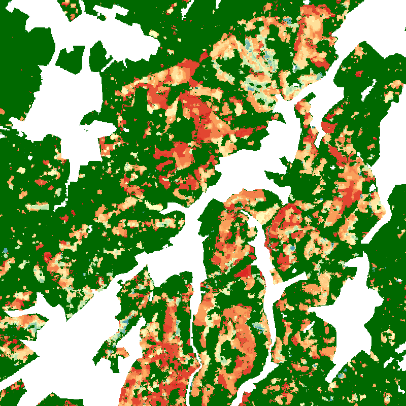
Tree Canopy Cover Loss Monthly - Landsat-8/Sentinel-2 - Germany, 2018-2021
The product shows tree canopy cover loss in Germany between January 2018 and April 2021 at monthly temporal and 10 m spatial resolution. The basic principle behind this map is to compute monthly composites of the disturbance index (DI, Healey et al. 2005), a spectral index sensitive to forest disturbance, from all available Sentinel-2 and Landsat-8 data with less than 80 % cloud cover. These monthly composites are then compared to a median composite of the DI for 2017, which serves as a reference. After applying a threshold to the difference image, the time series of detected losses is checked for consistency. Only losses recorded continuously in all observations of a pixel until the end of the time series are considered. The dataset does not differentiate between the drivers of the losses. It depicts areas of natural disturbances (windthrow, fire, droughts, insect infestation) as well as sanitation and salvage logging, and regular forest harvest. The full description of the method and results can be found in Thonfeld et al. (2022).
Simple
- Date (Creation)
- 2022-08-11T00:00:00
- Citation identifier
- https://geoservice.dlr.de/catalogue/srv/metadata/3a5f8f67-aede-4325-aee6-83330ea046f1
- Presentation form
- Digital map
- Other citation details
-
DOI: 10.15489/z0g96v5kwg14
- Purpose
-
This map shows the tree canopy cover losses in Germany for the period of January 2018 until April 2021.
- Status
- Completed
- Maintenance and update frequency
- As needed
-
GEMET - INSPIRE themes, version 1.0
-
-
Land cover
-
- Keywords
-
-
opendata
-
Forest
-
Canopy Cover Loss
-
Drought
-
Disturbance Index
-
Sentinel-2
-
Landsat-8
-
Germany
-
- Use limitation
-
Nutzungseinschränkungen: Das DLR ist nicht haftbar für Schäden, die sich aus der Nutzung ergeben. / Use Limitations: DLR not liable for damage resulting from use.
- Access constraints
- Other restrictions
- Use constraints
- Other restrictions
- Other constraints
-
Nutzungsbedingungen: Lizenz, https://creativecommons.org/licenses/by/4.0/ Terms of use: License, https://creativecommons.org/licenses/by/4.0/
- Other constraints
-
{"id": "cc-by-4.0",
"name": "Creative-Commons - Attribution 4.0 International (CC BY 4.0)",
"url": " http://dcat-ap.de/def/licenses/cc-by/4.0 ",
"quelle": "Copyright DLR (2022)"}
- Spatial representation type
- Grid
- Denominator
- 20000
- Language
- English
- Character set
- UTF8
- Topic category
-
- Biota
))
- Begin date
- 2018-01-01T00:00:00
- End date
- 2021-04-30T23:59:59
- Unique resource identifier
- EPSG:3035 - ETRS89-extended / LAEA Europe
- Number of dimensions
- 2
- Dimension name
- Column
- Dimension size
- 71084
- Resolution
- 10 m
- Dimension name
- Row
- Dimension size
- 90002
- Resolution
- 10 m
- Cell geometry
- Area
- Transformation parameter availability
- No
- Distribution format
-
-
GeoTIFF
()
-
GeoTIFF
()
- OnLine resource
- EOC Geoservice Dataset ( WWW:LINK-1.0-http--link )
- OnLine resource
-
TREE_CANOPY_COVER_LOSS_P1M
(
OGC:WMS
)
WMS Access: Tree Canopy Cover Loss Germany 2018-2021
- OnLine resource
- HTTP download Tree Canopy Cover Loss Monthly - Germany, 2018-2021 ( WWW:LINK-1.0-http--link )
- OnLine resource
-
Sorge um den deutschen Wald
(
WWW:LINK-1.0-http--link
)
DLR News - Webpage
- Hierarchy level
- Dataset
Domain consistency
- Measure identification
- INSPIRE / Conformity_001
Conformance result
- Date (Publication)
- 2010-12-08
- Explanation
-
See the referenced specification.
- Pass
- Yes
- Statement
-
All Sentinel-2 and Landsat-8 data since 2017 available through the Google Earth Engine (GEE) with less than 80 % cloud cover were used.
- Description
-
Tree Canopy Cover Loss - Germany 2018-2021 - Processing
Processing:
The Sentinel-2 level 2 surface reflectance dataset available from GEE was processed using sen2cor and the Landsat-8 level 2 dataset is composed of surface reflectance data processed using the land surface reflectance code (LaSRC).
Quality Assurance:
With regard to the spatial accuracy, our assessment based on pixel counts revealed an overall accuracy of 92.8%. The sample-based accuracy assessment revealed an overall accuracy of 98% ± 1% and an area estimate of 643,735 ha ± 120,726 ha canopy cover loss. This map is a modified version of the paper, where we removed low-confidence losses, particularly during early 2018 and the 2020/21 winter.
- File identifier
- 3a5f8f67-aede-4325-aee6-83330ea046f1 XML
- Metadata language
- English
- Character set
- UTF8
- Hierarchy level
- Dataset
- Hierarchy level name
-
Dataset
- Date stamp
- 2025-02-03T08:34:48
- Metadata standard name
-
ISO 19115-1:2014/19139
Overviews
Spatial extent
Provided by
