 My GeoNetwork catalogue
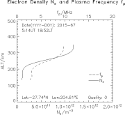
SWACI - Vertical Electron Density Profiles
SWACI is a research project of DLR supported by the State Government of Mecklenburg-Vorpommern. Radio signals, transmitted by modern communication and navigation systems may be heavily disturbed by space weather hazards. Thus, severe temporal and spatial changes of the electron density in the ionosphere may significantly degrade the signal quality of various radio systems which even may lead to a complete loss of the signal. By providing specific space weather information, in particular now- and forecast of the ionospheric state, the accuracy and reliability of impacted communication and navigation systems shall be improved.
GPS radio occultation measurements onboard geo research satellites such as CHAMP and GRACE are used for retrieving vertical electron density profiles of the ionosphere. At present, only GPS measurements from GRACE are available. These data are routinely provided by GFZ Potsdam. Thus, the derived electron density profiles retrieved in SWACI are a common data product of DLR and GFZ Potsdam. Users are asked to acknowledge this in a proper way.
Simple
- Date (Creation)
- 2015-03-10T00:00:00
- Citation identifier
- https://geoservice.dlr.de/catalogue/srv/metadata/3aaa51c5-a317-4dc8-bf2a-6096f53d1f51
- Presentation form
- Digital map
- Status
- Completed
- Maintenance and update frequency
- Not planned
-
GEMET - INSPIRE themes, version 1.0
-
-
Atmospheric conditions
-
- Keywords
-
-
urn:eop:DLR:EOWEB:Vertical-Electron-Density-Profiles
-
SWACI
-
Vertical-Electron-Density-Profiles
-
vertical electron density profiles
-
Ionosphere
-
- Use limitation
-
Conditional
- Access constraints
- Other restrictions
- Use constraints
- License
- Other constraints
-
Limited for public use
SWACI License
- Spatial representation type
- Grid
- Denominator
- 0
- Language
-
eng
- Character set
- UTF8
- Topic category
-
- Climatology, meteorology, atmosphere
))
- Begin date
- 2005-01-22T00:03:00
- End date
- 2008-01-04T23:48:00
- Reference system identifier
- EPSG / WGS 84 (EPSG:4326) / 7.4
- Distribution format
-
- OnLine resource
- Ionosphere Monitoring and Prediction Center Homepage ( WWW:LINK-1.0-http--link )
- Hierarchy level
- Series
Domain consistency
- Measure identification
- INSPIRE / Conformity_001
Conformance result
- Date (Publication)
- 2010-12-08
- Explanation
-
See the referenced specification
- Pass
- Yes
- Statement
-
For details see:
- Description
-
Please refer https://impc.dlr.de/products/ for more details.
- File identifier
- 3aaa51c5-a317-4dc8-bf2a-6096f53d1f51 XML
- Metadata language
- English
- Character set
- UTF8
- Hierarchy level
- Series
- Hierarchy level name
-
Dataseries
- Date stamp
- 2024-06-20T14:12:19
- Metadata standard name
-
ISO 19115-1:2014/19139
- Metadata standard version
-
1.0
Overviews

Spatial extent
Provided by
