 My GeoNetwork catalogue
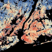
World Settlement Footprint (WSF) 3D - Building Area - Global, 90m
The World Settlement Footprint (WSF) 3D provides detailed quantification of the average height, total volume, total area and the fraction of buildings at 90 m resolution at a global scale.
It is generated using a modified version of the World Settlement Footprint human settlements mask derived from Sentinel-1 and Sentinel-2 satellite imagery in combination with digital elevation data and radar imagery collected by the TanDEM-X mission.
The framework includes three basic workflows: i) the estimation of the mean building height based on an analysis of height differences along potential building edges, ii) the determination of building fraction and total building area within each 90 m cell, and iii) the combination of the height information and building area in order to determine the average height and total built-up volume at 90 m gridding.
In addition, global height information on skyscrapers and high-rise buildings provided by the Emporis database is integrated into the processing framework, to improve the WSF 3D Building Height and subsequently the Building Volume Layer.
A comprehensive validation campaign has been performed to assess the accuracy of the dataset quantitatively by using VHR 3D building models from 19 globally distributed regions (~86,000 km2) as reference data.
The WSF 3D standard layers are provided in the format of Lempel-Ziv-Welch (LZW)-compressed GeoTiff files, with each file - or image tile - covering an area of 1 x 1 ° geographical lat/lon at a geometric resolution of 2.8 arcsec (~ 90 m at the equator). Following the system established by the TDX-DEM mission, the latitude resolution is decreased in multiple steps when moving towards the poles to compensate for the reduced circumference of the Earth.
INSPIRE
Identification
- File identifier
- 4208a63e-228b-4601-b4d9-a2b345fd1027 XML
- Hierarchy level
- Dataset
Online resource
- Protocol
-
WWW:LINK-1.0-http--link
- Protocol
-
OGC:WMS
- Protocol
-
OGC:WMS-http-get-capabilities
- Protocol
-
WWW:LINK-1.0-http--link
- Protocol
-
WWW:LINK-1.0-http--link
- Protocol
-
WWW:LINK-1.0-http--link
Resource identifier
- Metadata language
- English
- Spatial representation type
- Grid
Encoding
- Format
-
Cloud Optimized GeoTIFF
Projection
- code
- EPSG:4326
Classification of data and services
- Topic category
-
- Imagery base maps earth cover
Classification of data and services
Coupled resource
Coupled resource
Classification of data and services
Coupled resource
Coupled resource
Keywords
-
GEMET - INSPIRE themes, version 1.0
-
-
Land cover
-
Other keywords
- Keywords
-
-
opendata
-
DLR
-
EOC
-
building height
-
building density
-
building volume
-
urbanization
-
3D
-
global
-
Sentinel-1
-
Sentinel-2
-
TanDEM-X
-
inspireidentifiziert
-
Geographic coverage
))
Temporal reference
Temporal extent
- Begin
- 2012-01-01T00:00:00
- End
- 2019-12-31T23:59:00
Temporal extent
- Date (Creation)
- 2023-02-15T00:00:00
Quality and validity
- Lineage
-
The World Settlement Footprint 3D human settlements mask derived from Sentinel-1 and Sentinel-2 satellite imagery in combination with digital elevation data and radar imagery collected by the TanDEM-X mission.
- Denominator
- 180000
Conformity
Conformity
Conformity
Conformity
Conformity
Conformity
- Explanation
-
See the referenced specification
Restrictions on access and use
- Access constraints
- Es gelten keine Zugriffsbeschränkungen.
- Access constraints
-
Nutzungsbedingungen: Lizenz, https://creativecommons.org/licenses/by/4.0 / terms of use: https://creativecommons.org/licenses/by/4.0/
- Access constraints
-
{"id": "cc-by/4.0",
"name": "Creative Commons Namensnennung - 4.0 International (CC BY 4.0)",
"url": " http://dcat-ap.de/def/licenses/cc-by/4.0 ",
"quelle": "Copyright DLR (year of production)"}
Responsible organization (s)
Contact for the resource
- Organisation name
-
German Aerospace Center (DLR)
- Organisation name
-
German Aerospace Center (DLR)
- Organisation name
-
DLR/EOC Land Surface Dynamics
Responsible organization (s)
Contact for the resource
- Organisation name
-
German Aerospace Center (DLR)
- Organisation name
-
German Aerospace Center (DLR)
- Organisation name
-
DLR/EOC Land Surface Dynamics
Metadata information
Contact for the metadata
- Organisation name
-
German Aerospace Center(DLR)
- Date stamp
- 2025-02-03T09:03:30
- Metadata language
- English
- Character set
- UTF8
SDS
Conformance class 1: invocable
Access Point URL
Endpoint URL
Technical specification
Conformance class 2: interoperable
Access constraints
Limitation
Use constraints
Limitation
Responsible custodian
Contact for the resource
Overviews

Spatial extent
Provided by
