 My GeoNetwork catalogue
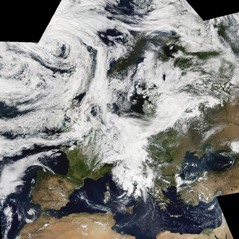
MODIS - Image Mosaic - Europe
The Moderate Resolution Imaging Spectroradiometer (MODIS) is a key instrument aboard the Terra (EOS AM-1) and Aqua (EOS PM-1) satellites. The MODIS-EU image mosaic is a seamless true color composite of all Terra and Acqua passes received at DLR during a single day. Daily and Near Real Time (NRT) products are available. For the composite, MODIS channels 1, 4, 3 are used. The channels are re-projected, radiometrically enhanced, and seamlessly stitched to obtain a visually appealing result.
Terra passes from north to south across the equator in the morning, while Aqua passes the equator south to north in the afternoon. Both MODIS instruments are viewing the entire Earth surface every 1 to 2 days, acquiring data in 36 spectral bands.
Simple
- Date (Creation)
- 2015-02-24T00:00:00
- Citation identifier
- https://geoservice.dlr.de/catalogue/srv/metadata/43487af3-1fd7-4b5b-8e50-db02a61479b9
- Presentation form
- Digital map
- Status
- On going
- Maintenance and update frequency
- Daily
-
GEMET - INSPIRE themes, version 1.0
-
-
Orthoimagery
-
- Keywords
-
-
MODIS-EU
-
MODIS
-
Moderate Resolution Imaging Spectroradiometer
-
Aqua
-
Terra
-
true color composite
-
visible wavelengths
-
Europe
-
- Use limitation
-
Nutzungseinschränkungen: DLR not liable for damage resulting from use
- Access constraints
- Copyright
- Use constraints
- Other restrictions
- Other constraints
-
Nutzungsbedingungen: Copyright
- Spatial representation type
- Grid
- Denominator
- 500000
- Language
-
eng
- Character set
- UTF8
- Topic category
-
- Climatology, meteorology, atmosphere
- Begin date
- 2015-03-30
))
- Distribution format
-
- OnLine resource
- DLR MODIS Information ( WWW:LINK-1.0-http--link )
- OnLine resource
-
MODIS_EU_DAILY
(
OGC:WMS
)
WMS access to MODIS-EU Daily
- OnLine resource
-
MODIS_EU_NRT
(
OGC:WMS
)
WMS access to MODIS-EU NRT
- OnLine resource
-
MODIS_EU_DAILY
(
OGC:WCS
)
WCS access to MODIS-EU Daily
- OnLine resource
- DLR MODIS-EU Website ( WWW:LINK-1.0-http--link )
- Hierarchy level
- Series
Domain consistency
- Measure identification
- INSPIRE / Conformity_001
Conformance result
- Date (Publication)
- 2010-12-08
- Explanation
-
See the referenced specification
- Pass
- Yes
- Statement
-
For details see:
https://www.dlr.de/de/eoc/forschung-transfer/themen/aktuelle-wetterbilder/modis-eu
- File identifier
- 43487af3-1fd7-4b5b-8e50-db02a61479b9 XML
- Metadata language
- English
- Character set
- UTF8
- Hierarchy level
- Series
- Hierarchy level name
-
Dataseries
- Date stamp
- 2024-09-27T14:05:10
- Metadata standard name
-
ISO 19115:2003/19139
- Metadata standard version
-
1.0
Overviews

Spatial extent
Provided by
