 My GeoNetwork catalogue
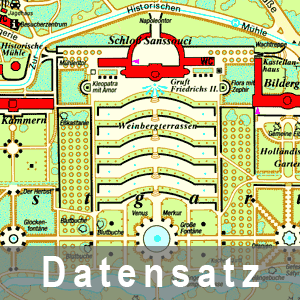
Parkpläne Potsdam 1 : 5 000 3-er Set
In Zusammenarbeit mit der Stiftung Preußische Schlösser und Gärten Berlin-Brandenburg sind bisher 4 Parkpläne von Potsdam und Rheinsberg im Maßstab 1 : 5 000 bzw. 1 : 3 000 erschienen (Park Sanssouci liegt auch als englische Ausgabe vor). Sie sollen der Orientierung der Besucher in den Parkanlagen dienen und zeigen neben den Schlössern auch wichtige Gehölze und die Standorte von Skulpturen an. Auf den Rückseiten befinden sich Erläuterungen und Fotos zu den Sehenswürdigkeiten. Die 3 Potsdamer Parkpläne - Neuer Garten, Park Babelsberg, Park Sanssouci - sind im Preis ermäßigt als Kartenset erhältlich.
INSPIRE
Identification
- File identifier
- 466725a4-aa9f-4c8a-8141-66a7e16c30ef XML
- Hierarchy level
- Dataset
Resource identifier
- Metadata language
- Deutsch
Encoding
Projection
- code
- EPSG:25833
Classification of data and services
- Topic category
-
- Imagery base maps earth cover
Classification of data and services
Coupled resource
Coupled resource
Classification of data and services
Coupled resource
Coupled resource
Keywords
-
BE/BB Schlagwortliste, Version 1.0
-
-
Vermessung
-
Other keywords
- Keywords
-
-
opendata
-
- Theme
-
-
1:5.000 - 1:10.000
-
1:1.000 - 1:5.000
-
bodenbedeckung
-
Karte
-
Geographic coverage
))
Temporal reference
Temporal extent
Temporal extent
- Date (Revision)
- 2007-05-01T00:00:00
- Date (Creation)
- 1990-01-01T00:00:00
Quality and validity
- Lineage
-
Eine Auskunft über die Herkunft der Daten erhalten Sie per Anfrage an die E-Mail kundenservice@geobasis-bb.de .
- Denominator
- 5000
Conformity
Conformity
Conformity
Conformity
Conformity
Conformity
Restrictions on access and use
- Access constraints
-
Die Daten können gemäß der „Datenlizenz Deutschland - Namensnennung - Version 2.0“ ( https://www.govdata.de/dl-de/by-2-0 ) genutzt werden. Namensnennung: "GeoBasis-DE/LGB", Beispiel: „© GeoBasis-DE/LGB, dl-de/by-2-0, (Daten geändert)“, (Klammer = optional)
- Access constraints
-
{"id":"dl-by-de/2.0","name":"Datenlizenz Deutschland - Namensnennung - Version 2.0","url":" https://www.govdata.de/dl-de/by-2-0","quelle":"Quelle : © GeoBasis-DE/LGB, dl-de/by-2-0"}
- Access constraints
- Es gelten keine Zugriffsbeschränkungen
Responsible organization (s)
Contact for the resource
- Organisation name
-
Landesvermessung und Geobasisinformation Brandenburg (LGB)
Responsible organization (s)
Contact for the resource
- Organisation name
-
Landesvermessung und Geobasisinformation Brandenburg (LGB)
Metadata information
Contact for the metadata
- Organisation name
-
Landesvermessung und Geobasisinformation Brandenburg (LGB)
- Date stamp
- 2025-07-31T09:25:24
- Metadata language
- Deutsch
- Character set
- UTF8
SDS
Conformance class 1: invocable
Access Point URL
Endpoint URL
Technical specification
Conformance class 2: interoperable
Access constraints
Limitation
Use constraints
Limitation
Responsible custodian
Contact for the resource
Overviews
Spatial extent
Provided by
