 My GeoNetwork catalogue
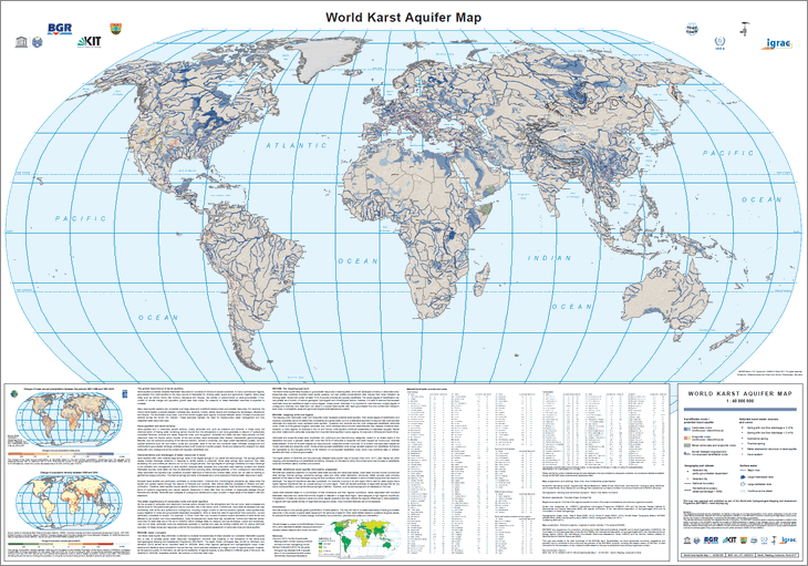
World Karst Aquifer Map (WHYMAP WOKAM)
The World-wide Hydrogeological Mapping and Assessment Programme (WHYMAP) provides data and information about the earth´s major groundwater resources. The World Karst Aquifer Map (WOKAM) allows a more precise global quantification of karst systems. The map will help to increase awareness of karst groundwater resources in the context of global water issues and will serve as a basis for other karst-related research questions at global scales: for example those related to climate change, biodiversity, food production, geochemical cycles and urbanisation.
INSPIRE
Identification
- File identifier
- 473d851c-4694-4050-a37f-ee421170eca8 XML
- Hierarchy level
- Dataset
Online resource
Resource identifier
- code
-
6e557f76-ac0a-404b-bad1-045b291d88cd
- Metadata language
- English
- Spatial representation type
- Vector
Encoding
- Format
-
Shapefile
- Version
-
n/a
Projection
- code
- EPSG:4326
Classification of data and services
- Topic category
-
- Geoscientific information
Classification of data and services
Coupled resource
Coupled resource
Classification of data and services
Coupled resource
Coupled resource
Keywords
-
GEMET - INSPIRE themes, version 1.0
-
-
Geologie
-
Geology
-
-
GEMET - Concepts, version 2.4
-
-
Grundwasser
-
Hydrogeologie
-
Groundwater
-
Hydrogeology
-
Other keywords
- Theme
-
-
Karst
-
Aquifer
-
Grundwasserneubildung
-
Groundwater recharge
-
Grundwasservorkommen
-
Groundwater resources
-
Grundwasserentnahme
-
Groundwater abstraction
-
- Place
-
-
Weltweit
-
World-wide
-
Geographic coverage
))
Temporal reference
Temporal extent
Temporal extent
- Date (Publication)
- 2017-09-25
Quality and validity
- Lineage
-
World-wide Hydrogeological Mapping and Assessment Programme (WHYMAP)
- Denominator
- 25000000
Conformity
Conformity
Conformity
Conformity
Conformity
Conformity
- Explanation
-
siehe dazu die angegebene Durchführungsbestimmung
Restrictions on access and use
- Access constraints
- Es gelten keine Zugriffsbeschränkungen
- Access constraints
-
Allgemeine Geschäftsbedingungen, siehe https://www.bgr.bund.de/AGB - General terms and conditions, see https://www.bgr.bund.de/AGB_en . Die bereitgestellten Informationen sind bei Weiterverwendung wie folgt zu zitieren: Datenquelle: WHYMAP WOKAM, (C) BGR Berlin, IAH Reading, KIT Karlsruhe, UNESCO Paris 2017
Responsible organization (s)
Contact for the resource
- Organisation name
-
Bundesanstalt für Geowissenschaften und Rohstoffe (BGR)
Responsible organization (s)
Contact for the resource
- Organisation name
-
Bundesanstalt für Geowissenschaften und Rohstoffe (BGR)
Metadata information
Contact for the metadata
- Organisation name
-
Bundesanstalt für Geowissenschaften und Rohstoffe (BGR)
- Date stamp
- 2025-03-07
- Metadata language
- English
- Character set
- UTF8
SDS
Conformance class 1: invocable
Access Point URL
Endpoint URL
Technical specification
Conformance class 2: interoperable
Access constraints
Limitation
Use constraints
Limitation
Responsible custodian
Contact for the resource
Overviews
Spatial extent
Provided by
