 My GeoNetwork catalogue
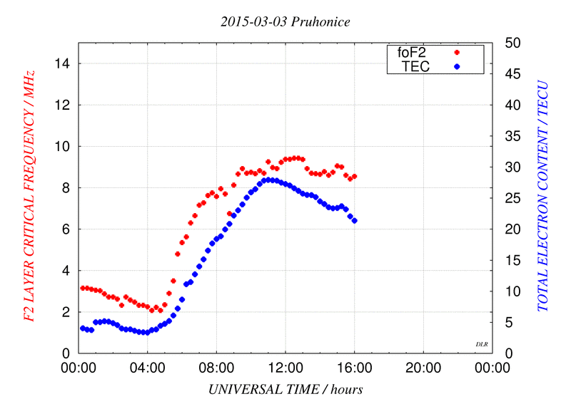
SWACI - Equivalent Slab Thickness (F2 Layer Critical Frequency)
SWACI is a research project of DLR supported by the State Government of Mecklenburg-Vorpommern. Radio signals, transmitted by modern communication and navigation systems may be heavily disturbed by space weather hazards. Thus, severe temporal and spatial changes of the electron density in the ionosphere may significantly degrade the signal quality of various radio systems which even may lead to a complete loss of the signal. By providing specific space weather information, in particular now- and forecast of the ionospheric state, the accuracy and reliability of impacted communication and navigation systems shall be improved.
The equivalent slab thickness is a measure of the width of the shape of the vertical electron density profile of the ionosphere. The equivalent slab thickness is defined by the ratio of the total electron content (TEC) and the peak electron density of the local ionosphere. To compute the peak electron density, vertical sounding data from different ionosonde stations are used. The corresponding TEC data are extracted from the SWACI TEC maps.
For more details see http://swaciweb.dlr.de/data-and-products/public/slabthickness/?L= 1.
Simple
- Date (Creation)
- 2015-03-10T00:00:00
- Citation identifier
- https://geoservice.dlr.de/catalogue/srv/metadata/48f2756a-5c47-4898-875a-81e9c88babec
- Presentation form
- Digital map
- Status
- Completed
- Maintenance and update frequency
- Not planned
-
GEMET - INSPIRE themes, version 1.0
-
-
Atmospheric conditions
-
- Keywords
-
-
urn:eop:DLR:EOWEB:SWACI.SLAB-THICKNESS.L2
-
SWACI
-
Equivalent Slab Thickness
-
Ionosphere
-
F2 Layer Critical Frequency
-
- Use limitation
-
Conditional
- Access constraints
- Other restrictions
- Use constraints
- License
- Other constraints
-
Limited for public use
SWACI License
- Spatial representation type
- Grid
- Denominator
- 0
- Language
-
eng
- Character set
- UTF8
- Topic category
-
- Climatology, meteorology, atmosphere
))
- Begin date
- 2008-01-24T00:00:00
- End date
- 2013-01-31T23:56:00
- Reference system identifier
- EPSG / WGS 84 (EPSG:4326) / 7.4
- Distribution format
-
- OnLine resource
- Ionosphere Monitoring and Prediction Center Homepage ( WWW:LINK-1.0-http--link )
- Hierarchy level
- Series
Domain consistency
- Measure identification
- INSPIRE / Conformity_001
Conformance result
- Date (Publication)
- 2010-12-08
- Explanation
-
See the referenced specification
- Pass
- Yes
- Statement
-
For details see:
- Description
-
Please refer to https://impc.dlr.de/products/ for more details.
- File identifier
- 48f2756a-5c47-4898-875a-81e9c88babec XML
- Metadata language
- English
- Character set
- UTF8
- Hierarchy level
- Series
- Hierarchy level name
-
Dataseries
- Date stamp
- 2024-06-20T14:12:07
- Metadata standard name
-
ISO 19115-1:2014/19139
- Metadata standard version
-
1.0
Overviews
Spatial extent
Provided by
