 My GeoNetwork catalogue
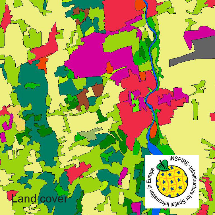
INSPIRE Land Cover CLC5 2018
This dataset clc5 (2018) describes the landscape according to the CORINE Land Cover (CLC) nomenclature. These classes contain mainly information about landcover mixed with some aspects of landuse. CLC5 is based on the more detailed German landcover model from 2018 (LBM-DE2018) which uses separate classes for landcover and landuse and attribute-information about percentage of vegetation and sealing. The mimimum unit for an object is 1 ha. For the CLC5 dataset landcover and landuse classes are combined to unique CLC-classes taking into account the percentage of vegetation and sealing , followed by a generalisation process.
INSPIRE
Identification
- File identifier
- 4CE24067-37A0-4395-A641-64CC80121470 XML
- Hierarchy level
- Dataset
Resource identifier
- Metadata language
- English
- Spatial representation type
- Vector
Encoding
- Format
-
GML
- Version
-
3.2.1
Projection
Classification of data and services
- Topic category
-
- Imagery base maps earth cover
Classification of data and services
Coupled resource
Coupled resource
Classification of data and services
Coupled resource
Coupled resource
Keywords
-
GEMET - INSPIRE themes, version 1.0
-
GEMET - Concepts, version 3.1
Other keywords
- Keywords
-
-
CLC
-
Landbedeckung
-
Landnutzung
-
Bodenbedeckung
-
LBM-DE
-
opendata
-
- Keywords
-
-
inspireidentifiziert
-
Geographic coverage
))
Temporal reference
Temporal extent
- Begin
- 2018-01-01T00:00:00.000+01:00
- End
- 2018-12-31T00:00:00.000+01:00
Temporal extent
- Date (Creation)
- 2019-07-24T00:00:00.000+02:00
Quality and validity
- Lineage
-
The CLC5 data (minimum mapping unit 5 hectares) are derived from the land cover model for Germany (LBM-DE) by generalization. This dataset, in which the minimum mapping is 1 hectare, contains land cover and land use information for each object. By means of a cross-table the single combinations of land cover and land use attributes are transformed - with regard to the degrees of sealing and vegetation that are stored in LBM-DE as well - into unique CLC codes.
- Denominator
- 25000
Conformity
Conformity
Conformity
Conformity
Conformity
Conformity
- Explanation
-
see the referenced specification
- Explanation
-
see the referenced specification
Restrictions on access and use
- Access constraints
-
Quellenvermerk: © GeoBasis-DE / BKG < year of last data download >
- Access constraints
-
{"id":"geoNutz/20130319","name":"Nutzungsbestimmungen für die Bereitstellung von Geodaten des Bundes","url":" https://sg.geodatenzentrum.de/web_public/gdz/lizenz/geonutzv.pdf","quelle":"© GeoBasis-DE / BKG < year of last data download >"}
- Access constraints
- no limitations to public access
Responsible organization (s)
Contact for the resource
- Organisation name
-
Federal Agency for Cartography and Geodesy
- Organisation name
-
Federal Agency for Cartography and Geodesy
Responsible organization (s)
Contact for the resource
- Organisation name
-
Federal Agency for Cartography and Geodesy
- Organisation name
-
Federal Agency for Cartography and Geodesy
Metadata information
Contact for the metadata
- Organisation name
-
Federal Agency for Cartography and Geodesy
- Date stamp
- 2026-03-23
- Metadata language
- English
- Character set
- UTF8
SDS
Conformance class 1: invocable
Access Point URL
Endpoint URL
Technical specification
Conformance class 2: interoperable
Access constraints
Limitation
Use constraints
Limitation
Responsible custodian
Contact for the resource
Overviews
Spatial extent
Provided by
