 My GeoNetwork catalogue
Geochemical Atlas of the Federal Republic of Germany (1985), Stream water samples, Sample points
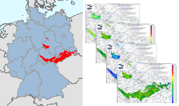
In the former GDR, investigations were carried out between 1980 and 1990 to estimate the raw material potential in the pre-Upper Permian bedrock units (Flechtingen-Rosslau Hills, Harz Mountains, Saxon Granulite Mountains, Thuringian Forest, Thuringian-Vogtlandian Slate Mountains, Ore Mountains, Elbe Valley Region/Lusatia), which lie at the earth's surface or are slightly covered by the Cenozoic. Part of these investigations was a geochemical prospection in the area of the above mentioned bedrock units. Approximately 18,000 water and 17,500 stream sediment samples were taken and geochemically analysed over an area of almost 15,000 km². The results of these investigations were documented in sub-reports on the individual bedrock units as well as in the "Final Report on the Comparative Evaluation of the Raw Material Potential in the Bedrock Units of the GDR" (Röllig et al., 1990; in German). These data from the bedrock units in the southern part of the former GDR are unique in their high sampling density (> 1 sample/km²) and provide a comprehensive geochemical survey of these areas. All later geochemical investigations (Geochemical Atlas 2000 as well as within the framework of GEMAS and FOREGS) were carried out with a much lower sampling density. These valuable and irretrievable data are now made generally available via the BGR geoportal. In addition to the digital provision of the original data material, area-wide distribution maps are made available for the first time, which were generated using modern computer-assisted methods. The downloads show the distribution of the sample points and the sampled area in the form of a (smoothed) 1 km buffer around the sample points.
Simple
- Alternate title
-
GchA-D(E)1990, Stream water samples, Sample points
- Date (Publication)
- 2023-10-31
- Citation identifier
- https://registry.gdi-de.org/id/de.bund.bgr.csw/88887fe1-1535-366b-008b-8176032c4ebf
- Status
- Completed
- Theme
-
-
Atlas
-
Bachwässer
-
Geochemie
-
Geochemische Karte
-
Elementkonzentration
-
flächenhafte Verteilung
-
Prospektion
-
Umweltgeochemie
-
atlas
-
stream waters
-
geochemistry
-
geochemical map
-
element concentration
-
spatial distribution
-
prospection
-
environmental geochemistry
-
- Place
-
-
Deutschland
-
Germany
-
- Access constraints
- Other restrictions
- Other constraints
- Es gelten keine Zugriffsbeschränkungen
- Use constraints
- Other restrictions
- Other constraints
-
Allgemeine Geschäftsbedingungen, s. https://www.bgr.bund.de/agb - General Terms and Conditions, s. https://www.bgr.bund.de/agb_en
- Spatial representation type
- Grid
- Spatial representation type
- Vector
- Denominator
- 1000000
- Language
- Deutsch
- Character set
- UTF8
- Topic category
-
- Geoscientific information
))
- Unique resource identifier
- EPSG:32632
- Distribution format
-
-
Shapefile
(
n/a
)
-
PDF
(
n/a
)
-
PNG
(
n/a
)
-
Shapefile
(
n/a
)
- OnLine resource
- Environmental aspects of the regional geochemical survey in the southern part of East Germany
- OnLine resource
-
Karten (PDF, 300 dpi)
Karten im Format PDF (300 dpi)
- OnLine resource
-
Karten (PDF, 600 dpi)
Karten im Format PDF (600 dpi)
- OnLine resource
-
Karten (PNG, 300 dpi)
Karten im Format PNG (300 dpi)
- OnLine resource
-
Karten (PNG, 600 dpi)
Karten im Format PNG (600 dpi)
- OnLine resource
-
Karten (shp)
Karten im Format ESRI Shape
- OnLine resource
- Karte im BGR-Geoviewer
- Hierarchy level
- Dataset
Conformance result
- Date (Publication)
- 2010-12-08
- Explanation
-
siehe dazu die angegebene Durchführungsbestimmung
- Statement
-
Röllig, G., Berger, W., Birke, M., Enderlein, F., Grosche, G., Kaberdin, B., Kampe, A., Krull, P., Kruse, B., Kunz, I., Rauch, U., Rentzsch, J., Schwandtke, E., Sehm, K., Söllig, A., Thomas, U. & Wünsch, K. (1990): Abschlußbericht zur vergleichenden Bewertung der Rohstofführung in den Grundgebirgseinheiten im Südteil der DDR. Gesellschaft für Umwelt- und Wirtschaftsgeologie mbH: S. 807; Berlin (Archiv der Bundesanstalt für Geowissenschaften und Rohstoffe, Hannover, Archivnummer 1004927).
- File identifier
- 4a0d5d33-ab64-4a3d-81a4-28b5677ed2d1 XML
- Metadata language
- Deutsch
- Character set
- UTF8
- Parent identifier
-
Geochemical prospection in the bedrock units in the southern part of the former GDR (1990), Element concentrations in stream waters and stream sediments, Single element maps.
d2680805-2328-4741-b7d9-a2f86fc0285b
- Hierarchy level
- Dataset
- Hierarchy level name
-
Geochemie
- Date stamp
- 2025-03-10
- Metadata standard name
-
INSPIRE Metadata Implementing Rules: Technical Guidelines based on EN ISO 19115 and EN ISO 19119
- Metadata standard version
-
n/a
Overviews
Spatial extent
Provided by
