 My GeoNetwork catalogue
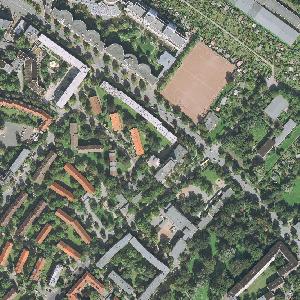
WMS Digitale Orthophotos - Bodenauflösung 20 cm
Darstellungsdienst für die Digitalen Orthophotos - Bodenauflösung 20cm für das Gebiet der Bundesrepublik Deutschland. Der Datenbestand beinhaltet die Digitalen Orthophotos (DOP) Deutschlands als georeferenzierte, differentiell entzerrte Luftbilder der Vermessungsverwaltungen der Bundesländer.
Die Bilddaten werden mit einer Bodenauflösung von 20 cm (1 Bildpixel = 20 cm x 20 cm) an das BKG geliefert. Daraus entsteht ein deutschlandweiter Datensatz DOP20, der über Webservices in voller Auflösung nutzbar ist.
Detaillierte Aktualitätsangaben zu den Bildern sind über einen weiteren, frei zugänglichen Webservice abrufbar (wms_info, wfs_info). Maßstab: 1:null; Bodenauflösung: 0.2m; Scanauflösung (DPI): null
Simple
Identification info
- Alternate title
-
Digitale Orthophotos
- Alternate title
-
wms_dop
- Date (Creation)
- 2009-04-17T00:00:00.000+02:00
- Status
- On going
+49 69 6333-251
https://www.bkg.bund.de
+49 69 6333-235
https://www.bkg.bund.de
- Maintenance and update frequency
- Biannually
- Update scope
- Service
-
Service Classification, version 1.0
-
-
infoMapAccessService
-
- Keywords
-
-
Digitale Orthophotos
-
DOP
-
Bund
-
Bundesamt für Kartographie und Geodäsie
-
ViewService
-
WMS
-
infoMapAccessService
-
BKG
-
Deutschland
-
DOP20
-
Hintergrundkarte
-
- Keywords
-
-
AdVMIS
-
-
GEMET - Concepts, version 3.1
- Use constraints
- Other restrictions
- Access constraints
- Other restrictions
- Other constraints
-
Es gelten Zugriffsbeschränkungen. Für den Erwerb von Nutzungsrechten wenden Sie sich deshalb bitte an die Zentrale Stelle Geotopographie der AdV (ZSGT) / Dienstleistungszentrum (DLZ) des Bundesamtes für Kartographie und Geodäsie: https://www.bkg.bund.de/DE/Service/Kontakt/kontakt.html .
- Service Type
- view
- Service Version
-
OGC:WMS 1.3.0
- Service Version
-
OGC:WMS 1.1.1
- Extent type code
- Yes
- Geographic identifier
- Raumbezug des Datensatzes
))
- Coupling Type
- Tight
Contains Operations
- Operation Name
-
GetCapabilities
- Distributed Computing Platforms
- Web services
- Connect Point
- https://sg.geodatenzentrum.de/wms_dop?
Contains Operations
- Operation Name
-
GetMap
- Distributed Computing Platforms
- Web services
- Connect Point
- https://sg.geodatenzentrum.de/wms_dop?
Contains Operations
- Operation Name
-
GetFeatureInfo
- Distributed Computing Platforms
- Web services
- Connect Point
- https://sg.geodatenzentrum.de/wms_dop?
- Operates On
- Reference system identifier
- CRS 84: CRS 84 / mathematisch
- Unique resource identifier
- EPSG 4326: WGS 84 / geographisch
- Unique resource identifier
- EPSG 25832: ETRS89 / UTM Zone 32N
- Unique resource identifier
- EPSG 25833: ETRS89 / UTM Zone 33N
- Unique resource identifier
- EPSG 32632: WGS 84 / UTM Zone 32N
- Unique resource identifier
- EPSG 32633: WGS 84 / UTM Zone 33N
- Unique resource identifier
- EPSG 4647: ETRS89 / UTM Zone 32N (zE-N)
- Unique resource identifier
- EPSG 5650: ETRS89 / UTM Zone 33N (zE-N)
- Unique resource identifier
- EPSG 31466: DHDN / Gauss-Krüger Zone 2
- Unique resource identifier
- EPSG 31467: DHDN / Gauss-Krüger Zone 3
- Unique resource identifier
- EPSG 31468: DHDN / Gauss-Krüger Zone 4
- Unique resource identifier
- EPSG 31469: DHDN / Gauss-Krüger Zone 5
- Unique resource identifier
- EPSG 5676: DHDN / Gauss-Krüger Zone 2 (E-N)
- Unique resource identifier
- EPSG 5677: DHDN / Gauss-Krüger Zone 3 (E-N)
- Unique resource identifier
- EPSG 5678: DHDN / Gauss-Krüger Zone 4 (E-N)
- Unique resource identifier
- EPSG 5679: DHDN / Gauss-Krüger Zone 5 (E-N)
- Unique resource identifier
- EPSG 3857: WGS 84 / Pseudo-Mercator
- Unique resource identifier
- EPSG 4258: ETRS89 / geographisch
- Unique resource identifier
- EPSG 3034: ETRS89 / LCC Europa
- Unique resource identifier
- EPSG 3035: ETRS89 / LAEA Europa
- Unique resource identifier
- EPSG 3044: ETRS89 / UTM Zone 32N (N-E)
- Unique resource identifier
- EPSG 3045: ETRS89 / UTM Zone 33N (N-E)
- Unique resource identifier
- EPSG 4839: ETRS89 / LCC Deutschland (N-E)
- Unique resource identifier
- EPSG 3068: DHDN / Soldner Berlin
- Distribution format
-
-
PNG
()
-
TIFF
()
-
JPEG
()
-
PNG
()
- OnLine resource
- Produktseite des Geodatenzentrums
- OnLine resource
- Dienst "WMS Digitale Orthophotos - Bodenauflösung 20 cm" (GetCapabilities) ( OGC Web Map Service )
- Hierarchy level
- Service
- Other
-
service
Conformance result
- Date (Publication)
- 2006-03-15
- Explanation
-
see the referenced specification
- Pass
- Yes
- File identifier
- 4b041142-059c-4d74-9ac1-868763640447 XML
- Metadata language
- Deutsch
- Character set
- UTF8
- Hierarchy level
- Service
- Hierarchy level name
-
service
- Date stamp
- 2026-05-05
- Metadata standard name
-
ISO19119
- Metadata standard version
-
2005/PDAM 1
Overviews
Spatial extent
Provided by
