 My GeoNetwork catalogue
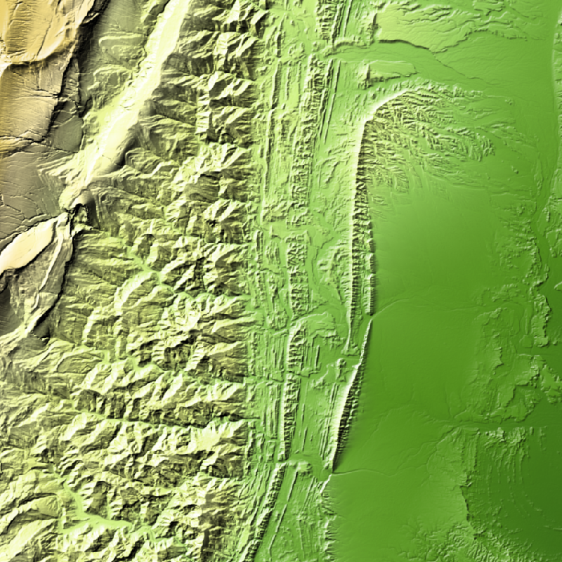
TanDEM-X - Edited Digital Elevation Model (EDEM) - Global, 30m
TanDEM-X (TerraSAR-X add-on for Digital Elevation Measurements) is an Earth observation radar mission that consists of a SAR interferometer built by two almost identical satellites flying in close formation. With a typical separation between the satellites of 120 m to 500 m a global Digital Elevation Model (DEM) has been generated.
The TanDEM-X 30m EDEM is a product variant of the global Digital Elevation Model (DEM) acquired in the frame of the German TanDEM-X mission between 2010 and 2014, and has a reduced pixel spacing of 1 arcseconds (arsec), which corresponds to 30m at the equator. An automated edition was developed by the Microwaves and Radar Institute at the German Aerospace Center (DLR) to have a full and clean coverage of all Earth’s landmasses from pole to pole.
Simple
- Date (Creation)
- 2023-11-17T12:00:00
- Citation identifier
- https://geoservice.dlr.de/catalogue/srv/metadata/4ee664df-ceb9-4d59-bc6e-4df4da54b53d
- Presentation form
- Digital map
- Purpose
-
The TanDEM-X 30m Edited DEM has been edited in order to have a full coverage.
- Status
- Completed
- Maintenance and update frequency
- As needed
- Keywords
-
-
DLR
-
TDM
-
HR
-
TanDEM-X
-
EDEM
-
DEM
-
Digital Elevation Model
-
TDX-1
-
TSX-1
-
TDM 30m EDEM
-
Edited DEM
-
Global
-
-
GEMET - INSPIRE themes, version 1.0
-
-
Elevation
-
- Use limitation
-
Nutzungseinschränkungen: Das DLR ist nicht haftbar für Schäden, die sich aus der Nutzung ergeben. / Use Limitations: DLR not liable for damage resulting from use.
- Access constraints
- Other restrictions
- Other constraints
- Öffentlicher Zugriff beschränkt entsprechend Artikel 13(1)(e) der INSPIRE-Richtlinie: e) aufgrund nachteiliger Auswirkungen auf die Rechte des geistigen Eigentums
- Use constraints
- Other restrictions
- Other constraints
-
Nutzungsbedingungen: https://geoservice.dlr.de/resources/licenses/tdm30-edited/License_for_the_Utilization_of_TanDEM-X_30m-EDEM_DCM_for_Scientific_Use.pdf Terms of Use: https://geoservice.dlr.de/resources/licenses/tdm30-edited/License_for_the_Utilization_of_TanDEM-X_30m-EDEM_DCM_for_Scientific_Use.pdf
- Spatial representation type
- Grid
- Denominator
- 60000
- Language
- English
- Character set
- UTF8
- Topic category
-
- Elevation
))
- Begin date
- 2010-12-12T04:04:33
- End date
- 2015-01-16T00:37:12
- Unique resource identifier
- EPSG:4326
- Number of dimensions
- 3
- Dimension name
- Column
- Dimension size
- 1296000
- Resolution
- 30 m
- Dimension name
- Row
- Dimension size
- 648000
- Resolution
- 30 m
- Dimension name
- Vertical
- Dimension size
- 1
- Resolution
- 1 m
- Cell geometry
- Area
- Transformation parameter availability
- No
- Distribution format
-
-
GeoTIFF
()
-
GeoTIFF
()
- OnLine resource
-
TanDEM-X DEM access - non-scientific users
(
WWW:LINK-1.0-http--link
)
Webpage for accessing/ordering TanDEM-X elevation models for non-scientific users.
- OnLine resource
-
TanDEM-X DEM access - scientific users
(
WWW:LINK-1.0-http--link
)
Webpage with links and description for accessing TanDEM-X elevation models for scientific users.
- OnLine resource
-
EOC Geoservice Map Context
(
WWW:LINK-1.0-http--link
)
EOC Geoservice Map Context (tdm:edem30)
- OnLine resource
-
EOC Download Service
(
WWW:LINK-1.0-http--link
)
TanDEM-X Edited Digital Elevation Model (EDEM) - EOC Download Service
- OnLine resource
-
TDM30_EDEM_EGM
(
OGC:WMS
)
WMS Access: TDM30 Edited Digital Elevation Model (EDEM)
- OnLine resource
-
TDM30_EDEM_HSD
(
OGC:WMS
)
WMS Access: TDM30 Hill Shade Display (HSD)
- OnLine resource
-
TDM30_EDEM_EDM
(
OGC:WMS
)
WMS Access: TDM30 Editing Mask (EDM)
- OnLine resource
-
TDM30_EDEM_HEM
(
OGC:WMS
)
WMS Access: TDM30 Height Error Map (HEM)
- OnLine resource
-
TDM30_EDEM_LCM
(
OGC:WMS
)
WMS Access: TDM30 Land Cover Map (LCM)
- OnLine resource
-
TDM30_EDEM_HSC
(
OGC:WMS
)
WMS Access: TDM30 Hill Shade Combined (HSC)
- OnLine resource
-
TDM30_EDEM_HSM
(
OGC:WMS
)
WMS Access: TDM30 Hill Shade Multidirectional (HSM)
- OnLine resource
-
TDM30 - EOC Geoservice Data Guide
(
WWW:LINK-1.0-http--link
)
EOC Geoservice Data Guide
- Hierarchy level
- Dataset
Domain consistency
- Measure identification
- INSPIRE / Conformity_001
Conformance result
- Date (Publication)
- 2010-12-08
- Explanation
-
See the referenced specification
- Pass
- Yes
- Statement
-
TDM 30 EDEM has been edited using the following DEMs for filling gaps are AW3D30, Nasadem, Lidar, REMA DEM and Arctic DEM.
- Description
-
Data:
TanDEM-X DEM Product in 30m is considered as base Product. A new Water Bodies Layer (WBL) has been calculated considering the coherence of single scenes and a watershed algorithm. The WBL is used to separete the areas to be flattened (water) and filled (voids), which are edited with different technics and saved pixelwise in the Editing Mask (EDM). The editing process has been performed fully automatically, besides the center of Antarctica < - 88°, which has been edited in polar coordinates.
Quality Assurance:
The quality of the edited areas depends strongly from the used references, and the complexity of the waterbodies.
- File identifier
- 4ee664df-ceb9-4d59-bc6e-4df4da54b53d XML
- Metadata language
- English
- Character set
- UTF8
- Hierarchy level
- Dataset
- Date stamp
- 2024-06-27T14:44:46
- Metadata standard name
-
ISO 19115:2014/19139
- Metadata standard version
-
1.0
Overviews
Spatial extent
Provided by
