 My GeoNetwork catalogue
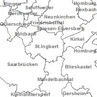
Windpotenziale - Gemeinden
Der Kartendienst stellt die Geodaten der Windpotenzialstudie und die Windkraftanlagen des Saarlandes dar.:Gemeinden
INSPIRE
Identification
- File identifier
- 51f5ad91-e024-7183-1154-ff39db66a508 XML
- Hierarchy level
- Service
Online resource
- Protocol
-
OGC:WMS-1.1.1-http-get-map
Resource identifier
Encoding
Projection
Classification of data and services
- Service Type
- view
- Coupling Type
- Tight
Coupled resource
Coupled resource
Classification of data and services
- Service Type
- view
- Coupling Type
- Tight
Coupled resource
Coupled resource
Keywords
Other keywords
- Keywords
-
-
Geobasisdaten
-
Verwaltungseinheiten
-
opendata
-
infoMapAccessService
-
Geographic coverage
))
Temporal reference
Temporal extent
Temporal extent
- Date (Revision)
- 2025-04-15
Conformity
Conformity
Conformity
Conformity
Conformity
Conformity
- Explanation
-
No explanation available
- Explanation
-
No explanation available
- Explanation
-
No explanation available
- Explanation
-
No explanation available
- Explanation
-
No explanation available
- Explanation
-
No explanation available
- Explanation
-
No explanation available
- Explanation
-
No explanation available
Restrictions on access and use
- Access constraints
- INSPIRE: Keine Beschränkungen des öffentlichen Zugangs: Es existieren keine Beschränkungen des öffentlichen Zugangs zu Daten und Diensten
- Access constraints
-
Lizenz: cc-by-4.0 - Namensnennung 4.0 International - https://creativecommons.org/licenses/by/4.0/deed.de - Quellenvermerk: © GDI-SL (Jahr)
- Access constraints
-
{"id":"cc-by-4.0","name":"Namensnennung 4.0 International","url":" https://creativecommons.org/licenses/by/4.0/deed.de","quelle":"© GDI-SL (Jahr)"}
Responsible organization (s)
Contact for the resource
- Organisation name
-
Ministerium für Umwelt, Klima, Mobilität, Agrar und Verbraucherschutz
Responsible organization (s)
Contact for the resource
- Organisation name
-
Ministerium für Umwelt, Klima, Mobilität, Agrar und Verbraucherschutz
Metadata information
Contact for the metadata
- Organisation name
-
GDI-Saarland
- Date stamp
- 2025-04-15
- Metadata language
- Deutsch
SDS
Conformance class 1: invocable
- Pass
- Yes
- Pass
- Yes
- Pass
- Yes
- Pass
- Yes
- Pass
- Yes
- Pass
- Yes
- Pass
- Yes
- Pass
- Yes
Access Point URL
Endpoint URL
Technical specification
- Date
- Explanation
-
No explanation available
- Date
- Explanation
-
No explanation available
- Date
- Explanation
-
No explanation available
- Date
- Explanation
-
No explanation available
- Date
- Explanation
-
No explanation available
- Date
- Explanation
-
No explanation available
- Date
- Explanation
-
No explanation available
- Date
- Explanation
-
No explanation available
Conformance class 2: interoperable
Access constraints
- Access constraints
- Other restrictions
- Other constraints
- INSPIRE: Keine Beschränkungen des öffentlichen Zugangs: Es existieren keine Beschränkungen des öffentlichen Zugangs zu Daten und Diensten
Limitation
Use constraints
Limitation
- string
-
Lizenz: cc-by-4.0 - Namensnennung 4.0 International - https://creativecommons.org/licenses/by/4.0/deed.de - Quellenvermerk: © GDI-SL (Jahr)
- string
-
{"id":"cc-by-4.0","name":"Namensnennung 4.0 International","url":" https://creativecommons.org/licenses/by/4.0/deed.de","quelle":"© GDI-SL (Jahr)"}
Responsible custodian
Contact for the resource
Conformance class 3: harmonized
Contains Operations
- Operation Name
-
GetCapabilities
- Distributed Computing Platforms
- Web services
Overviews
Spatial extent
Provided by
