 My GeoNetwork catalogue
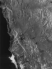
TerraSAR-X - Stripmap Images (TerraSAR-X StripMap)
This collection contains radar image products of the German national TerraSAR-X mission acquired in StripMap mode. StripMap imaging allows for a spatial resolution of up to 3 m at a scene size of 30 km (across swath) x 50-1650 km (in orbit direction). TerraSAR-X is a sun-synchronous polar-orbiting, all-weather, day-and-night X-band radar earth observation mission realized in the frame of a public-private partnership between the German Aerospace Center (DLR) and Airbus Defence and Space.
For more information concerning the TerraSAR-X mission, the reader is referred to:
Simple
- Date (Creation)
- 2015-05-05T00:00:00
- Citation identifier
- https://geoservice.dlr.de/catalogue/srv/metadata/53554204-282b-457e-b36d-a168679a0c1f
- Presentation form
- Digital map
- Status
- On going
https://www.intelligence-airbusds.com/contact/technical-request/technical-imagery/
- Maintenance and update frequency
- Continual
-
GEMET - INSPIRE themes, version 1.0
-
-
Orthoimagery
-
- Keywords
-
-
Satellite
-
Earth Observation
-
TerraSAR-X
-
TSX-1
-
TDX-1
-
SAR
-
X-Band
-
StripMap
-
urn:eop:DLR:EOWEB:TSX-1.SAR.L1b-Stripmap
-
TSX-1.SAR.L1b-Stripmap
-
FEDEO
-
- Use limitation
-
DLR not liable for damage resulting from use
- Access constraints
- Restricted
- Use constraints
- Other restrictions
- Other constraints
-
Nutzungsbedingungen: License
- Use limitation
-
Nutzungseinschränkungen: DLR not liable for damage resulting from use
- Spatial representation type
- Grid
- Denominator
- 6000
- Language
-
eng
- Character set
- UTF8
- Topic category
-
- Imagery base maps earth cover
))
- Begin date
- 2007-06-15T02:14:00
- Reference system identifier
- UTM/UPS
- Distribution format
-
- OnLine resource
-
TerraSAR-X data access - non-scientific users
(
WWW:LINK-1.0-http--link
)
Webpage for accessing/ordering TerraSAR-X data for non-scientific users.
- OnLine resource
-
TerraSAR-X data access - scientific users
(
WWW:LINK-1.0-http--link
)
Webpage with links and description regarding TerraSAR-X data access for scientific users.
- OnLine resource
-
TerraSAR-X StripMap
(
WWW:LINK-1.0-http--link
)
EOWEB GeoPortal
- OnLine resource
-
TerraSAR-X StripMap
(
WWW:LINK-1.0-http--partners
)
Airbus Defence & Space
- OnLine resource
-
Additional information on the TerraSAR-X mission
(
WWW:LINK-1.0-http--related
)
DLR mission website
- Hierarchy level
- Series
Domain consistency
- Measure identification
- INSPIRE / Conformity_001
Conformance result
- Date (Publication)
- 2010-12-08
- Explanation
-
See the referenced specification
- Pass
- Yes
- Statement
-
Input data sets:
- Orbit products
- Attitude products
- Extracted house-keeping parameters
Please refer to http://www.dlr.de/dlr/en/desktopdefault.aspx/tabid-10377/565_read-436/ for more details.
- File identifier
- 53554204-282b-457e-b36d-a168679a0c1f XML
- Metadata language
- English
- Character set
- UTF8
- Hierarchy level
- Series
- Hierarchy level name
-
Dataseries
- Date stamp
- 2024-10-14T06:24:04
- Metadata standard name
-
ISO 19115-1:2014/19139
- Metadata standard version
-
2003/Cor.1:2006
Overviews

Spatial extent
Provided by
