 My GeoNetwork catalogue
SWACI - Vertical Electron Density Distribution
SWACI is a research project of DLR supported by the State Government of Mecklenburg-Vorpommern. Radio signals, transmitted by modern communication and navigation systems may be heavily disturbed by space weather hazards. Thus, severe temporal and spatial changes of the electron density in the ionosphere may significantly degrade the signal quality of various radio systems which even may lead to a complete loss of the signal. By providing specific space weather information, in particular now- and forecast of the ionospheric state, the accuracy and reliability of impacted communication and navigation systems shall be improved.
NmF2 Maps and 3D electron density distribution:
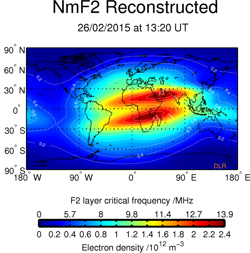
According to the pioneer work of Sir E. Appleton the vertical structure of the terrestrial ionosphere may be devided into different layers (D, E, F1, F2) with different physical characteristics. The layers are primarily characterized by its height and peak electron density. Typical plasma frequencies /electron densities are in the order of 10 MHz /1012 electrons / m3.
Shown are here global maps of the peak electron density of the F2 layer and related electron density maps at selected altitudes. The figures provide a first estimation of the three dimensional electron density distributions around the globe. For more details see http://swaciweb.dlr.de/data-and-products/public/nmf2/?L= 1.
Simple
- Date (Creation)
- 2015-02-26T00:00:00
- Citation identifier
- https://geoservice.dlr.de/catalogue/srv/metadata/55400e28-60b3-4cd4-adfc-00dd0a330756
- Presentation form
- Digital map
- Status
- On going
- Maintenance and update frequency
- Not planned
-
GEMET - INSPIRE themes, version 1.0
-
-
Atmospheric conditions
-
- Keywords
-
-
urn:eop:DLR:EOWEB:Vertical-Electron-Density-Distribution
-
SWACI
-
Vertical-Electron-Density-Distribution
-
NmF2
-
3D electron density distribution
-
Ionosphere
-
- Use limitation
-
Conditional
- Access constraints
- Other restrictions
- Use constraints
- License
- Other constraints
-
Limited for public use
SWACI License
- Spatial representation type
- Grid
- Denominator
- 0
- Language
-
eng
- Character set
- UTF8
- Topic category
-
- Climatology, meteorology, atmosphere
))
- Begin date
- 2008-01-04T23:48:00
- End date
- 2008-01-25T01:43:00
- Reference system identifier
- EPSG / WGS 84 (EPSG:4326) / 7.4
- Distribution format
-
- OnLine resource
- Ionosphere Monitoring and Prediction Center Homepage ( WWW:LINK-1.0-http--link )
- Hierarchy level
- Series
Domain consistency
- Measure identification
- INSPIRE / Conformity_001
Conformance result
- Date (Publication)
- 2010-12-08
- Explanation
-
See the referenced specification
- Pass
- Yes
- Statement
-
For details see:
- Description
-
Please refer to https://impc.dlr.de/products/ for more details.
- File identifier
- 55400e28-60b3-4cd4-adfc-00dd0a330756 XML
- Metadata language
- English
- Character set
- UTF8
- Hierarchy level
- Series
- Hierarchy level name
-
Dataseries
- Date stamp
- 2025-01-22T12:29:08
- Metadata standard name
-
ISO 19115-1:2014/19139
- Metadata standard version
-
1.0
Overviews
Spatial extent
Provided by
