 My GeoNetwork catalogue
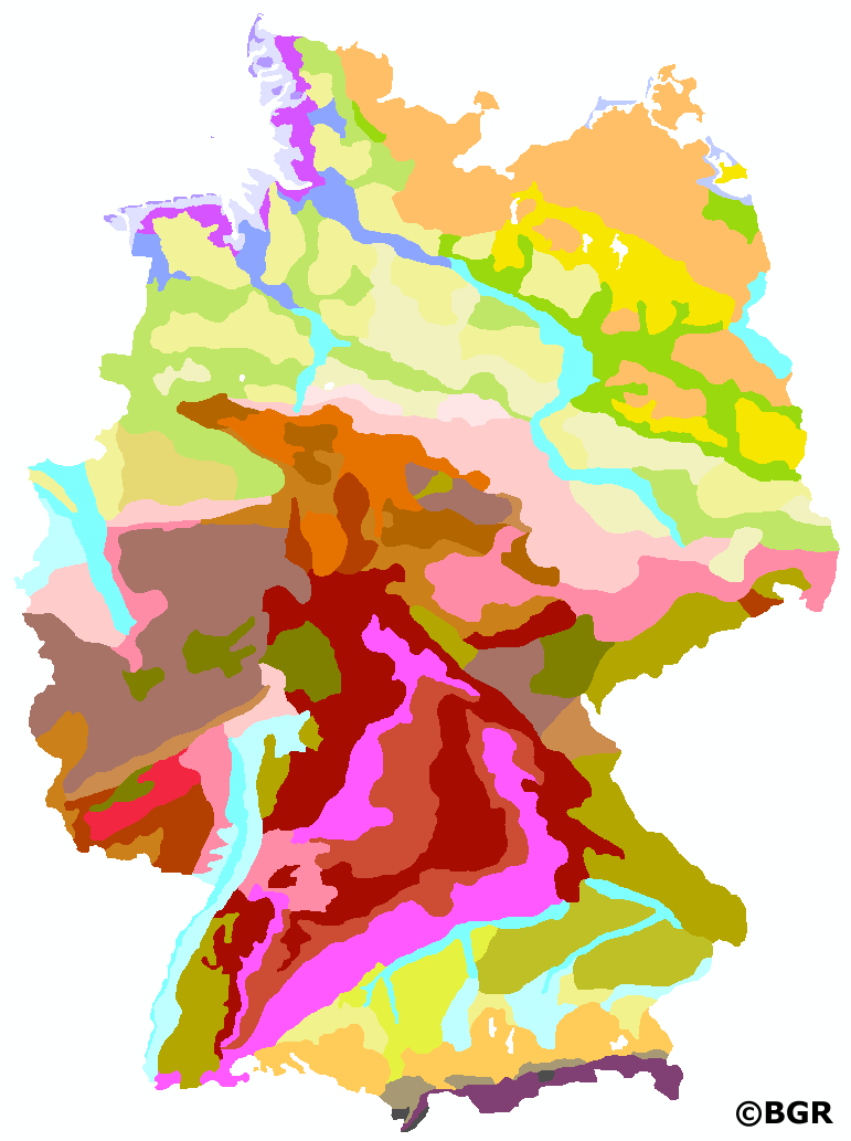
Soil Landscapes of the Federal Republic of Germany 1:5,000,000
Small-scale soil maps at scales of 1:200,000 to 1:5,000,000 are usually compiled from large- or medium-scale soil maps by summarizing the soil units depicted there. A uniform pedoregional classification is required to ensure a comparable approach across regions. The presented data set at the aggregation level of the soil landscapes covers the 36 most important soil-relevant lithogenetic units in Germany and is based on the map of the soil landscapes at a scale of 1:250,000, version 1.4, which in turn was derived from the BUEK200/BUEK250. For the map scale 1:5,000,000 the units were generalized. More detailed information on the soil regions and soil landscapes of the Federal Republic of Germany can be found in the Soil Mapping Guide (KA5), Chapter 6.5 from page 335.
INSPIRE
Identification
- File identifier
- 57399937-858F-4065-AC1E-62C1788AFCEE XML
- Hierarchy level
- Dataset
Online resource
Resource identifier
- code
-
8F21B444-A4E0-4569-AE40-AA0A0D573556
- Metadata language
- Deutsch
- Spatial representation type
- Vector
Encoding
- Format
-
PDF
- Version
-
n/a
- Format
-
Shapefile
- Version
-
n/a
- Format
-
JPEG
- Version
-
n/a
- Format
-
PNG
- Version
-
n/a
- Format
-
TIFF
- Version
-
n/a
Projection
- code
- EPSG:3034
Classification of data and services
- Topic category
-
- Geoscientific information
Classification of data and services
Coupled resource
Coupled resource
Classification of data and services
Coupled resource
Coupled resource
Keywords
-
GEMET - INSPIRE themes, version 1.0
-
-
Boden
-
Soil
-
-
GEMET - Concepts, version 2.4
-
-
Bodenart
-
Bodengestaltung
-
Bodenkarte
-
Bodenfunktion
-
Bodenbelastung
-
Bodenfruchtbarkeit
-
Bodennutzung
-
Bodenbildung
-
-
SGD-Liste
-
-
Bodengruppe
-
Bodenverbreitung
-
Bodeneigenschaften
-
-
Freies Schlagwort
-
-
Bodensystematik
-
Bodeninformationssystem
-
Bodenausgangsgestein
-
Bodengroßlandschaft
-
Bodengesellschaft
-
FISBo BGR
-
opendata
-
Other keywords
- Place
-
-
Bundesrepublik Deutschland
-
Geographic coverage
))
Temporal reference
Temporal extent
Temporal extent
- Date (Creation)
- 2022-09-01
- Date (Publication)
- 2023-01-31
Quality and validity
- Lineage
-
Bodengroßlandschaften von Deutschland 1:250.000. Im Landesteil Mecklenburg-Vorpommern Einarbeitung von Änderungsvorschlägen des LUNG Mecklenburg-Vorpommern (Frank Idler, 21. September 2021).
- Denominator
- 5000000
Conformity
Conformity
Conformity
Conformity
Conformity
Conformity
- Explanation
-
siehe dazu die angegebene Durchführungsbestimmung
Restrictions on access and use
- Access constraints
- Es gelten keine Zugriffsbeschränkungen
- Access constraints
-
Allgemeine Geschäftsbedingungen, siehe http://www.bgr.bund.de/AGB - General terms and conditions, see http://www.bgr.bund.de/AGB_en . Die bereitgestellten Informationen sind bei Weiterverwendung wie folgt zu zitieren: Datenquelle: BGL5000 V4.0, (C) BGR, Hannover, 2023.
- Access constraints
-
Dieser Datensatz kann gemäß der "Nutzungsbestimmungen für die Bereitstellung von Geodaten des Bundes" ( https://sg.geodatenzentrum.de/web_public/gdz/lizenz/geonutzv.pdf ) genutzt werden.
- Access constraints
-
{"id": "geoNutz/20130319", "name": "Nutzungsbestimmungen für die Bereitstellung von Geodaten des Bundes", "url": " https://sg.geodatenzentrum.de/web_public/gdz/lizenz/geonutzv.pdf ", "quelle": "BGL5000 V4.0, (C) BGR, Hannover, 2023"}
Responsible organization (s)
Contact for the resource
- Organisation name
-
Bundesanstalt für Geowissenschaften und Rohstoffe (BGR)
Responsible organization (s)
Contact for the resource
- Organisation name
-
Bundesanstalt für Geowissenschaften und Rohstoffe (BGR)
Metadata information
Contact for the metadata
- Organisation name
-
Bundesanstalt für Geowissenschaften und Rohstoffe (BGR)
- Date stamp
- 2023-08-22
- Metadata language
- Deutsch
- Character set
- UTF8
SDS
Conformance class 1: invocable
Access Point URL
Endpoint URL
Technical specification
Conformance class 2: interoperable
Access constraints
Limitation
Use constraints
Limitation
Responsible custodian
Contact for the resource
Overviews
Spatial extent
Provided by
