 My GeoNetwork catalogue
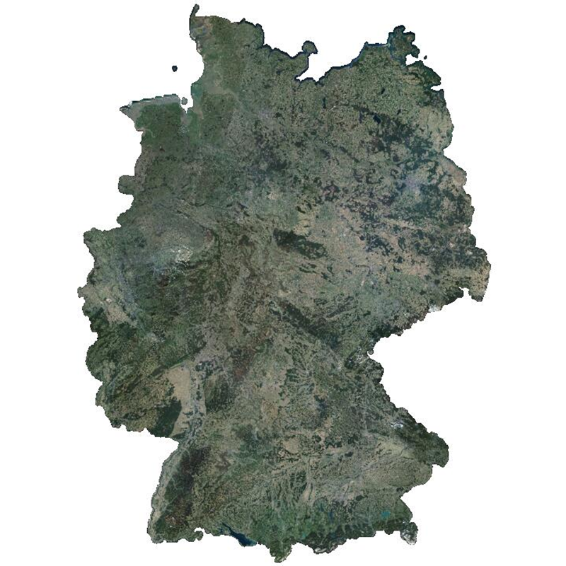
RapidEye Science Archive (RESA) - Level 3M Mosaic - Germany, 2015
The RapidEye RESA Germany Mosaic provides a nearly cloud-free view of the country’s geography, natural resources, and infrastructure. It is composed of 374,240 sqkm of multi-spectral RapidEye imagery, acquired between April and October 2015. The product is being provided in the framework of the RapidEye Science Archive (RESA) agreement.
Co-funded by the German Federal Government, the fleet of RapidEye satellites were launched from the Baikonur cosmodrome in Kazakhstan in 2008. The satellites are now owned by Planet Labs, Inc. The RapidEye Earth observation system comprises five satellites equipped with high-resolution optical sensors. With a spatial resolution of 6.5 m the 5-band instruments operate in the visible and near-infrared portions of the electromagnetic spectrum. With its high repetition rate the RapidEye constellation can image each point on the Earth’s at least once per day.
- Identification
- Distribution
- Quality
- Spatial rep.
- Ref. system
- Content
- Portrayal
- Metadata
- Md. constraints
- Md. maintenance
- Schema info
Identification
Data identification
Citation
- Date (Creation)
- 2018-01-31T12:00:00
- Citation identifier
- https://geoservice.dlr.de/catalogue/srv/metadata/5740f178-e802-47d8-a28c-08edd33a7a5d
- Presentation form
- Digital map
- Purpose
-
The RapidEye mosaic and can be used as background imagery or for geographic and strategic analysis.
- Status
- Completed
- Maintenance and update frequency
- As needed
-
GEMET - INSPIRE themes, version 1.0
-
-
Orthoimagery
-
- Theme
-
-
RapidEye
-
REIS
-
Optical
-
visual wavelengths
-
Mosaic
-
2015
-
Germany
-
urn:eop:DLR:EOWEB:RapidEye.RESA.L3M
-
- Use limitation
-
Nutzungseinschränkungen: DLR not liable for damage resulting from use
Legal constraints
- Access constraints
- License
- Access constraints
- Other restrictions
- Other constraints
-
License (de): https://geoservice.dlr.de/egp/resources/files/RESA_user-license-de_v4.0.pdf
License (en): https://geoservice.dlr.de/egp/resources/files/RESA_user-license-en_v4.0.pdf
Legal constraints
- Use constraints
- License
- Use constraints
- Other restrictions
- Other constraints
-
Nutzungsbedingungen: https://geoservice.dlr.de/egp/resources/files/RESA_user-license-de_v4.0.pdf (de), https://geoservice.dlr.de/egp/resources/files/RESA_user-license-en_v4.0.pdf (en)
- Spatial representation type
- Grid
- Denominator
- 10000
- Language
-
eng
- Character set
- UTF8
- Topic category
-
- Imagery base maps earth cover
Extent
))
- Begin date
- 2015-04-01T00:00:00
- End date
- 2015-10-31T00:00:00
Distribution
Distribution
- Distribution format
-
Digital transfer options
- OnLine resource
-
Planet Labs Germany GmbH – RESA
(
WWW:LINK-1.0-http--link
)
For scientific users
- OnLine resource
-
Planet Labs, Inc.
(
WWW:LINK-1.0-http--link
)
For non-scientific users
- OnLine resource
-
RESA_L3M_GERMANY_2015
(
OGC:WMS
)
WMS Access RESA RapidEye Level 3M Mosaic Germany
Quality
Data quality
- Hierarchy level
- Dataset
Domain consistency
- Measure identification
- INSPIRE / Conformity_001
Conformance result
Citation
- Date (Publication)
- 2010-12-08
- Explanation
-
See the referenced specification
- Pass
- Yes
- Statement
-
RapidEye Mosaic products consist of multiple RapidEye image takes that have been orthorectified
and radiometrically color balanced to a uniform appearance that are then assembled to create a single,
seamless large area image. For details see: https://www.planet.com/assets/pdfs/1606.08_Spec_Sheet_RE%20Mosaics_Letter_ENG_FINAL.pdf
Spatial rep.
Grid spatial representation
- Number of dimensions
- 2
Dimension
- Dimension name
- Row
- Dimension size
- 1
- Resolution
- 5 m
Dimension
- Dimension name
- Column
- Dimension size
- 1
- Resolution
- 5 m
- Cell geometry
- Area
- Transformation parameter availability
- No
Ref. system
- Reference system identifier
- EPSG / ETRS89 / UTM zone 32N (EPSG:25832) / 8.6
Metadata
Metadata
- File identifier
- 5740f178-e802-47d8-a28c-08edd33a7a5d XML
- Metadata language
- English
- Character set
- UTF8
- Hierarchy level
- Dataset
- Date stamp
- 2024-06-20T14:12:11
- Metadata standard name
-
ISO 19115:2003/19139
- Metadata standard version
-
1.0
Overviews

Spatial extent
Provided by
