 My GeoNetwork catalogue
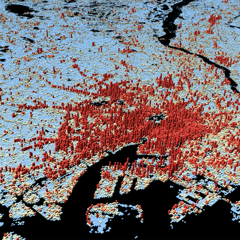
World Settlement Footprint (WSF) 3D - Vector Tiles - Global, 90m
This dataset is a derivative of the WSF3D raster dataset tailored for the web. As a tiled vector dataset, it enables dynamic client-side visualization of the WSF3D metrics
INSPIRE
Identification
- File identifier
- 57b9510f-a145-4b22-ac87-3389c53e6d2b XML
- Hierarchy level
- Dataset
Online resource
- Protocol
-
WWW:LINK-1.0-http--link
- Protocol
-
WWW:LINK-1.0-http--link
- Protocol
-
WWW:LINK-1.0-http--link
- Protocol
-
WWW:LINK-1.0-http--link
Resource identifier
- Metadata language
- English
- Spatial representation type
- Grid
Encoding
- Format
-
mbTiles
Projection
- code
- EPSG:3857
Classification of data and services
- Topic category
-
- Imagery base maps earth cover
Classification of data and services
Coupled resource
Coupled resource
Classification of data and services
Coupled resource
Coupled resource
Keywords
-
GEMET - INSPIRE themes, version 1.0
-
-
Land cover
-
Other keywords
- Keywords
-
-
opendata
-
DLR
-
EOC
-
building height
-
building density
-
building volume
-
urbanization
-
3D
-
global
-
Sentinel-1
-
Sentinel-2
-
TanDEM-X
-
vector tiles
-
inspireidentifiziert
-
Geographic coverage
))
Temporal reference
Temporal extent
- Begin
- 2012-01-01T00:00:00
- End
- 2019-12-31T23:59:00
Temporal extent
- Date (Creation)
- 2023-02-15T00:00:00
Quality and validity
- Lineage
-
The World Settlement Footprint 3D human settlements mask derived from Sentinel-1 and Sentinel-2 satellite imagery in combination with digital elevation data and radar imagery collected by the TanDEM-X mission.
- Denominator
- 180000
Conformity
Conformity
Conformity
Conformity
Conformity
Conformity
- Explanation
-
See the referenced specification
Restrictions on access and use
- Access constraints
- Es gelten keine Zugriffsbeschränkungen.
- Access constraints
-
Nutzungsbedingungen: Lizenz, https://creativecommons.org/licenses/by/4.0 / terms of use: https://creativecommons.org/licenses/by/4.0/
- Access constraints
-
{"id": "cc-by/4.0",
"name": "Creative Commons Namensnennung - 4.0 International (CC BY 4.0)",
"url": " http://dcat-ap.de/def/licenses/cc-by/4.0 ",
"quelle": "Copyright DLR (year of production)"}
Responsible organization (s)
Contact for the resource
- Organisation name
-
German Aerospace Center (DLR)
- Organisation name
-
German Aerospace Center (DLR)
- Organisation name
-
DLR/EOC Land Surface Dynamics
Responsible organization (s)
Contact for the resource
- Organisation name
-
German Aerospace Center (DLR)
- Organisation name
-
German Aerospace Center (DLR)
- Organisation name
-
DLR/EOC Land Surface Dynamics
Metadata information
Contact for the metadata
- Organisation name
-
German Aerospace Center(DLR)
- Date stamp
- 2025-02-03T09:01:16
- Metadata language
- English
- Character set
- UTF8
SDS
Conformance class 1: invocable
Access Point URL
Endpoint URL
Technical specification
Conformance class 2: interoperable
Access constraints
Limitation
Use constraints
Limitation
Responsible custodian
Contact for the resource
Overviews
Spatial extent
Provided by
