 My GeoNetwork catalogue
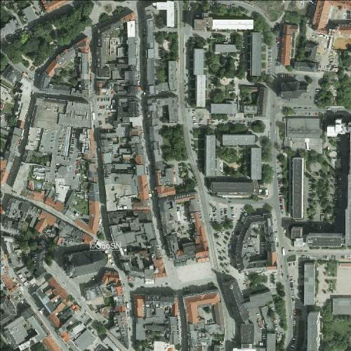
Luftbilder 2008
Geflogen wurde am 30.05.2008.
Die Bodenauflösung beträgt 20 cm.
- Identification
- Distribution
- Quality
- Spatial rep.
- Ref. system
- Content
- Portrayal
- Metadata
- Md. constraints
- Md. maintenance
- Schema info
Identification
MD_DataIdentification
CI_Citation
- alternateTitle
-
-
- date (Creation)
- 2009-12-15
- date (Revision)
- 2020-09-01
- date (Publication)
- 2011-09-08
- identifier
- https://geoportal.sachsen.de/md/5F02D92F-5074-4C05-8539-C9DFC7DFE85D
+49 375 83-6161
MD_MaintenanceInformation
- maintenanceAndUpdateFrequency
- Not planned
- maintenanceNote
-
keine Pflege (2008)
- Keywords
-
-
INTER|01 EINE Grundkarte wählen\Luftbilder\Luftbild 2008 ©GeoSN
-
Lufbilder
-
Luftbilder 2008
-
Orthophoto
-
- Use limitation
-
lt. Sächsisches Vermessungs- und Geobasisinformationsgesetz keine Veröffentlichung
Ausnahme: ZwickauGIS
- Use limitation
-
Nur für Erfüllungsgehilfen der Stadt Zwickau
Legal constraints
- accessConstraints
- Copyright
- Other constraints
-
Es gelten keine Zugriffsbeschränkungen
Legal constraints
- accessConstraints
- Other restrictions
- Other constraints
-
Es gelten keine Zugriffsbeschränkungen
Legal constraints
- useConstraints
- Copyright
- Use constraints
- Other restrictions
- otherConstraints
-
Nur für Erfüllungsgehilfen der Stadt Zwickau
- spatialRepresentationType
- Grid
- denominator
- 2500
- language
- Deutsch
- characterSet
- 8859 Part 1
- topicCategory
-
- Imagery base maps earth cover
))
- geographicIdentifier
- 140000000000
Distribution
MD_Distribution
- distributionFormat
-
-
TIF(TFW)
(
-
)
-
GeoTIF
(
-
)
-
JPG
(
-
)
-
GIF
(
-
)
-
TIF(TFW)
(
-
)
Quality
DQ_DataQuality
- level
- Dataset
DQ_ConformanceResult
CI_Citation
- date (Publication)
- 2010-12-08
- explanation
-
INSPIRE "Interoperabilität von Geodatensätzen und -diensten"
DQ_ConformanceResult
CI_Citation
- date (Publication)
- 2013-12-10
- explanation
-
INSPIRE Annex-Thema "Orthofotografie"
- statement
-
Vollständigkeit: vollständig
Genauigkeit: 50 - 100 cm
Aktualität: keine Pflege (2008)
Ref. system
- referenceSystemIdentifier
- http://www.opengis.net/def/crs/EPSG/0/31468
- referenceSystemIdentifier
- http://www.opengis.net/def/crs/EPSG/0/25833
Metadata
Metadata
- fileIdentifier
- 5F02D92F-5074-4C05-8539-C9DFC7DFE85D XML
- language
- Deutsch
- characterSet
- 8859 Part 1
- hierarchyLevel
- Dataset
- hierarchyLevelName
-
imageryBaseMapsEarthCover
- dateStamp
- 2022-05-19
- metadataStandardName
-
ISO19115
- metadataStandardVersion
-
2003/Cor.1:2006
+49 375 83-6161
Overviews
Spatial extent
Provided by
