 My GeoNetwork catalogue
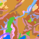
Bodenübersichtskarte 1:200.000 Bayern - WMS
Die Bodenübersichtskarte von Bayern 1:200.000 (BÜK200-BY) entstand durch Zusammenführung der bundesweit in Einzelblattschnitten vorliegenden und über die BGR erhältlichen Bodenübersichtskarte der Bundesrepublik Deutschland (BÜK200).
Für den Gesamtumgriff Bayerns wurden die Einzelblätter der BÜK200 zusammengefügt, Blattgrenzen aufgelöst, einzelne Flächen nochmals überarbeitet und die Inhalte der jeweiligen Kartenlegenden zusammengeführt, überarbeitet und gestrafft. Die BÜK200-BY liegt flächendeckend und blattschnittfrei vor, mit einer bayernspezifischen Generallegende.
Inhaltliche Differenzen zu den Einzelblättern der BÜK200 sind gering und in der Regel aufgrund des regionalen Ansatzes gewollt.
Die BÜK200 beruht auf der Aggregierung und Generalisierung der ebenfalls flächendeckend vorliegenden Übersichtsbodenkarte 1:25.000 (ÜBK25). Ein Datensatz an Referenzprofilen für die einzelnen Legendeneinheiten liegt vor.
Simple
Identification info
- Alternate title
-
Boden
- Date (Creation)
- 2020-11-25T00:00:00.000+01:00
- Status
- On going
- Maintenance and update frequency
- Not planned
- Update scope
- Service
-
Service Classification, version 1.0
-
-
infoMapAccessService
-
- Keywords
-
-
gdiby
-
Bodenkarte
-
Boden
-
sgd_Boden
-
- Use limitation
-
keine Einschränkungen
- Use constraints
- Other restrictions
- Other constraints
-
Creative Commons Namensnennung 4.0 International (CC BY 4.0); Datenquelle: Bayerisches Landesamt für Umwelt, www.lfu.bayern.de
- Other constraints
-
{"id":"cc-by/4.0","name":"Creative Commons Namensnennung 4.0 International (CC BY 4.0)","url":" https://creativecommons.org/licenses/by/4.0/deed.de","quelle":"Bayerisches Landesamt für Umwelt, www.lfu.bayern.de"}
- Access constraints
- Other restrictions
- Other constraints
- Es gelten keine Zugriffsbeschränkungen
- Service Type
- view
- Service Version
-
OGC:WMS 1.3.0
- Description
-
Der Dienst ist begrenzt auf die Landesfläche Bayerns.
))
- Coupling Type
- Tight
Contains Operations
- Operation Name
-
GetCapabilities
- Distributed Computing Platforms
- Web services
- Operation Description
-
application/vnd.ogc.wms_xml; text/xml;
- Connect Point
- https://www.lfu.bayern.de/gdi/wms/boden/buek200by?
Contains Operations
- Operation Name
-
GetMap
- Distributed Computing Platforms
- Web services
- Operation Description
-
image/bmp; image/jpeg; image/tiff; image/png; image/png8; image/png24; image/png32; image/gif; image/svg+xml;
- Connect Point
- https://www.lfu.bayern.de/gdi/wms/boden/buek200by?
Contains Operations
- Operation Name
-
GetFeatureInfo
- Distributed Computing Platforms
- Web services
- Operation Description
-
application/vnd.esri.wms_raw_xml; application/vnd.esri.wms_featureinfo_xml; application/vnd.ogc.wms_xml; application/geojson; text/xml; text/html; text/plain;
- Connect Point
- https://www.lfu.bayern.de/gdi/wms/boden/buek200by?
Contains Operations
- Operation Name
-
esri_wms:GetStyles
- Distributed Computing Platforms
- Web services
- Operation Description
-
application/vnd.ogc.sld+xml;
- Connect Point
- https://www.lfu.bayern.de/gdi/wms/boden/buek200by?
- Operates On
- Unique resource identifier
- EPSG 4326: WGS 84 / geographisch
- Unique resource identifier
- EPSG 4258: ETRS89 / geographisch
- Unique resource identifier
- EPSG 31467: DHDN / Gauss-Krüger Zone 3
- Unique resource identifier
- EPSG 31468: DHDN / Gauss-Krüger Zone 4
- Unique resource identifier
- EPSG 25832: ETRS89 / UTM Zone 32N
- Unique resource identifier
- EPSG 25833: ETRS89 / UTM Zone 33N
- Unique resource identifier
- EPSG 3857: WGS 84 / Pseudo-Mercator
- Unique resource identifier
- EPSG 31258: MGI / Austria GK M31
- Distribution format
-
-
Sonstiges
()
-
Sonstiges
()
Distributor
- Fees
-
geldleistungsfrei
- OnLine resource
- URL des Dienstes
- OnLine resource
-
Dienst "Bodenübersichtskarte 1:200.000 Bayern - WMS" (GetCapabilities)
(
OGC Web Map Service
)
application/vnd.ogc.wms_xml; text/xml;
- File identifier
- 5d87e523-efdd-452a-841c-8c9467d808bb XML
- Metadata language
- Deutsch
- Character set
- UTF8
- Hierarchy level
- Service
- Hierarchy level name
-
service
- Date stamp
- 2026-04-08
- Metadata standard name
-
ISO19119
- Metadata standard version
-
2005/PDAM 1
Overviews
Spatial extent
Provided by
