 My GeoNetwork catalogue
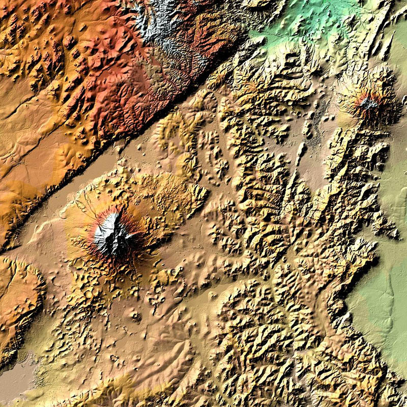
TanDEM-X - Digital Elevation Model (DEM) - Global, 12m
TanDEM-X (TerraSAR-X add-on for Digital Elevation Measurements) is an Earth observation radar mission that consists of a SAR interferometer built by two almost identical satellites flying in close formation. With a typical separation between the satellites of 120m to 500m a global Digital Elevation Model (DEM) has been generated.
The main objective of the TanDEM-X mission is to create a precise 3D map of the Earth's land surfaces that is homogeneous in quality and unprecedented in accuracy. The data acquisition was completed in 2015 and production of the global DEM was completed in September 2016. The absolute height error is with about 1m an order of magnitude below the 10m requirement.
The TanDEM-X 12m DEM is the nominal product variant of the global Digital Elevation Model (DEM) acquired in the frame of the German TanDEM-X mission between 2010 and 2015 with a spatial resolution of 0.4 arcseconds (12m at the equator). It covers all Earth’s landmasses from pole to pole.
For more information concerning the TanDEM-X mission, the reader is referred to: https://www.dlr.de/dlr/en/desktopdefault.aspx/tabid-10378/
INSPIRE
Identification
- File identifier
- 5eecdf4c-de57-4624-99e9-60086b032aea XML
- Hierarchy level
- Dataset
Online resource
- Protocol
-
WWW:LINK-1.0-http--link
- Protocol
-
WWW:LINK-1.0-http--link
- Protocol
-
WWW:LINK-1.0-http--link
Resource identifier
- Metadata language
- English
- Spatial representation type
- Grid
Encoding
Projection
- code
- EPSG:4326
Classification of data and services
- Topic category
-
- Elevation
Classification of data and services
Coupled resource
Coupled resource
Classification of data and services
Coupled resource
Coupled resource
Keywords
-
GEMET - INSPIRE themes, version 1.0
-
-
Elevation
-
Other keywords
- Keywords
-
-
TanDEM-X
-
Digital Elevation Model
-
TDX-1
-
TSX-1
-
SAR
-
X-Band
-
TDM-DEM-12m
-
urn:eop:DLR:EOWEB:TDM-DEM-12m
-
Global
-
FEDEO
-
Geographic coverage
))
Temporal reference
Temporal extent
- Begin
- 2010-12-12T04:04:33
- End
- 2015-01-16T00:37:12
Temporal extent
- Date (Creation)
- 2018-11-27T10:00:00
Quality and validity
- Lineage
-
For operational TanDEM-X acquisitions single DEM scenes with an extend of ~30km x 50km are generated by applying bistatic focusing, processing of individual interferograms, subsequent phase unwrapping and geocoding.
Remaining offsets and tilts in these DEM scenes are compensated in a DEM calibration step. Therefore, globally available ICESat (Ice, Cloud and Land Elevation Satellite) data is used as ground control points. Corrections are estimated in a block adjustment approach. The corrected DEM scenes are mosaicked to final DEM tiles. Manually conducted quality analysis is performed for every individual DEM tile.
For more information concerning TanDEM-X DEM product the reader is referred to
https://geoservice.dlr.de/web/dataguide/tdm90/pdfs/TD-GS-PS-0021_DEM-Product-Specification.pdf
Note:
Latitude pixel spacing:
• 0.4 arc-seconds
Longitude pixel spacing:
• 0° – 50° North/South: 0.4 arc-seconds
• 50° – 60° North/South 0.6 arc-seconds
• 60° – 70° North/South 0.8 arc-seconds
• 70° – 80° North/South 1.2 arc-seconds
• 80° – 85° North/South 2.0 arc-seconds
• 85° – 90° North/South 4.0 arc-seconds
- Denominator
- 24000
Conformity
Conformity
Conformity
Conformity
Conformity
Conformity
- Explanation
-
See the referenced specification
Restrictions on access and use
- Access constraints
-
Restricted
- Access constraints
-
License
Responsible organization (s)
Contact for the resource
- Organisation name
-
German Aerospace Center (DLR)
- Organisation name
-
German Aerospace Center (DLR)
Responsible organization (s)
Contact for the resource
- Organisation name
-
German Aerospace Center (DLR)
- Organisation name
-
German Aerospace Center (DLR)
Metadata information
Contact for the metadata
- Organisation name
-
German Aerospace Center (DLR)
- Date stamp
- 2024-09-27T12:48:45
- Metadata language
- English
- Character set
- UTF8
SDS
Conformance class 1: invocable
Access Point URL
Endpoint URL
Technical specification
Conformance class 2: interoperable
Access constraints
Limitation
Use constraints
Limitation
Responsible custodian
Contact for the resource
Overviews
Spatial extent
Provided by
