 My GeoNetwork catalogue
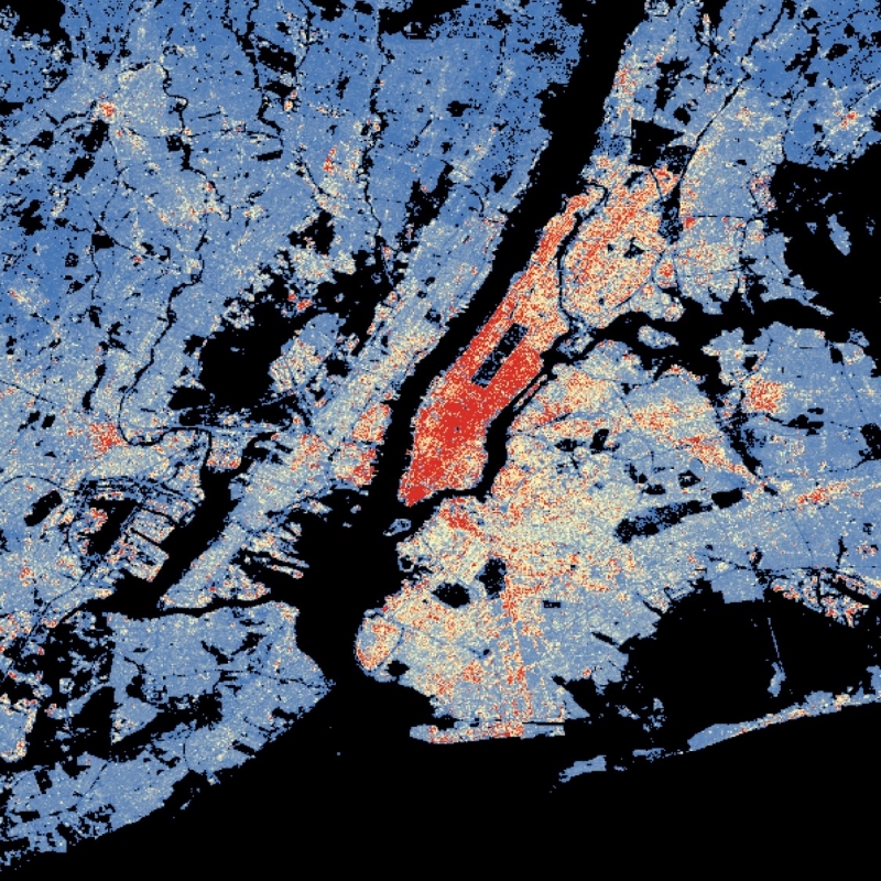
World Settlement Footprint (WSF) 3D - Building Volume - Global, 90m
The World Settlement Footprint (WSF) 3D provides detailed quantification of the average height, total volume, total area and the fraction of buildings at 90 m resolution at a global scale.
It is generated using a modified version of the World Settlement Footprint human settlements mask derived from Sentinel-1 and Sentinel-2 satellite imagery in combination with digital elevation data and radar imagery collected by the TanDEM-X mission.
The framework includes three basic workflows: i) the estimation of the mean building height based on an analysis of height differences along potential building edges, ii) the determination of building fraction and total building area within each 90 m cell, and iii) the combination of the height information and building area in order to determine the average height and total built-up volume at 90 m gridding.
In addition, global height information on skyscrapers and high-rise buildings provided by the Emporis database is integrated into the processing framework, to improve the WSF 3D Building Height and subsequently the Building Volume Layer.
A comprehensive validation campaign has been performed to assess the accuracy of the dataset quantitatively by using VHR 3D building models from 19 globally distributed regions (~86,000 km2) as reference data.
The WSF 3D standard layers are provided in the format of Lempel-Ziv-Welch (LZW)-compressed GeoTiff files, with each file - or image tile - covering an area of 1 x 1 ° geographical lat/lon at a geometric resolution of 2.8 arcsec (~ 90 m at the equator). Following the system established by the TDX-DEM mission, the latitude resolution is decreased in multiple steps when moving towards the poles to compensate for the reduced circumference of the Earth.
Simple
- Date (Creation)
- 2023-02-15T00:00:00
- Edition
-
2.0
- Citation identifier
- https://geoservice.dlr.de/catalogue/srv/metadata/60264acb-bc03-4804-b425-7b61c91caa08
- Presentation form
- Digital map
- Purpose
-
The World Settlement Footprint (WSF) 3D provides detailed quantification of the average height, total volume, total area and the fraction of buildings at 90 m resolution at a global scale.
- Status
- Completed
- Maintenance and update frequency
- As needed
- Keywords
-
-
opendata
-
DLR
-
EOC
-
building height
-
building density
-
building volume
-
urbanization
-
3D
-
global
-
Sentinel-1
-
Sentinel-2
-
TanDEM-X
-
inspireidentifiziert
-
-
GEMET - INSPIRE themes, version 1.0
-
-
Land cover
-
- Use limitation
-
Nutzungseinschränkungen: Das DLR ist nicht haftbar für Schäden, die sich aus der Nutzung ergeben. / Use Limitations: DLR not liable for damage resulting from use.
- Access constraints
- Other restrictions
- Other constraints
- Es gelten keine Zugriffsbeschränkungen.
- Use constraints
- Other restrictions
- Other constraints
-
Nutzungsbedingungen: Lizenz, https://creativecommons.org/licenses/by/4.0 / terms of use: https://creativecommons.org/licenses/by/4.0/
- Other constraints
-
{"id": "cc-by/4.0",
"name": "Creative Commons Namensnennung – 4.0 International (CC BY 4.0)",
"url": " http://dcat-ap.de/def/licenses/cc-by/4.0 ",
"quelle": "Copyright DLR (year of production)"}
- Spatial representation type
- Grid
- Denominator
- 180000
- Language
- English
- Character set
- UTF8
- Topic category
-
- Imagery base maps earth cover
))
- Begin date
- 2012-01-01T00:00:00
- End date
- 2019-12-31T23:59:00
- Unique resource identifier
- EPSG:4326
- Number of dimensions
- 2
- Dimension name
- Column
- Dimension size
- 462862
- Resolution
- 90 m
- Dimension name
- Row
- Dimension size
- 180001
- Resolution
- 90 m
- Cell geometry
- Area
- Transformation parameter availability
- No
- Distribution format
-
-
Cloud Optimized GeoTIFF
()
-
Cloud Optimized GeoTIFF
()
- OnLine resource
- EOC Geoservice Dataset ( WWW:LINK-1.0-http--link )
- OnLine resource
-
WSF3D_V02_BUILDINGVOLUME
(
OGC:WMS
)
World Settlement Footprint 3D - Building Volume
- OnLine resource
- https://geoservice.dlr.de/eoc/land/wms?SERVICE=WMS%26REQUEST=GetCapabilities ( OGC:WMS-http-get-capabilities )
- OnLine resource
- EOC Geoservice Map Context ( WWW:LINK-1.0-http--link )
- OnLine resource
- EOC Download Service ( WWW:LINK-1.0-http--link )
- OnLine resource
- DLR News ( WWW:LINK-1.0-http--link )
- Hierarchy level
- Dataset
Domain consistency
- Measure identification
- INSPIRE / Conformity_001
Conformance result
- Date (Publication)
- 2010-12-08
- Explanation
-
See the referenced specification
- Pass
- Yes
- Statement
-
The World Settlement Footprint 3D human settlements mask derived from Sentinel-1 and Sentinel-2 satellite imagery in combination with digital elevation data and radar imagery collected by the TanDEM-X mission.
- Description
-
World Settlement Footprint 3D - Building Volume Processing:
Data:
Sentinel-1 and Sentinel-2 satellite imagery at 10 m spatial resolution is used to generate the World Settlement Footprint (WSF) 2019. This layer is supplemented with information on the percent impervious (IMP) surface and serves as a human settlement mask.
The 12 m TanDEM-X Digital Elevation Model and the underlying 3 m Synthetic Aperture Radar (SAR) amplitude images give information on the vertical structuring within the built-up area.
Processing:
The total building volume per 90 m grid cell is determined by the combination of the building height information and the building area.
Quality Assurance:
A comprehensive validation campaign has been undertaken based on 3D building models obtained for 19 regions worldwide (~86,000 km2) and street-view samples indicating the number of floors for >130,000 individual buildings in 15 additional cities.
- File identifier
- 60264acb-bc03-4804-b425-7b61c91caa08 XML
- Metadata language
- English
- Character set
- UTF8
- Hierarchy level
- Dataset
- Hierarchy level name
-
Dataset
- Date stamp
- 2025-02-03T09:05:37
- Metadata standard name
-
19115-1:2014/19139
- Metadata standard version
-
2003/Cor.1:2006
Overviews

Spatial extent
Provided by
