 My GeoNetwork catalogue
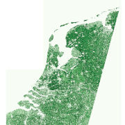
fCover - Sentinel-2 - Netherlands, 2016
The Sentinel-2 fractional vegetation cover (fCover) product for the Netherlands was produced as part of the NextGEOSS project at the German Aerospace Center (DLR). The goal is to derive abundance maps from atmospherically corrected Sentinel-2 multispectral images for: photosynthetically active vegetation (PV); and for combined non-photosynthetically active vegetation (NPV) and bare soil (BS).
The fCover product for the Netherlands has been generated by processing 10 cloud-free Sentinel-2 tiles which covered the country on 8 September 2016. The map has a spatial resolution of 60m x 60m. The Sentinel-2 scene classification layer was used to ensure that the spectral unmixing was only performed on areas of vegetation or soil.
The abundance maps were made by performing MESMA unmixing on each pixel from an endmember library of PV and combined NPV + BS spectra. The purest pixels in a scene, called endmembers, were extracted using the Spatial-Spectral Endmember Extraction (SSEE) approach. The PV and NPV+BS endmembers were classified with a random forest approach and selected to form the spectral library. The spectral library was used in the µMESMA unmixing to get the PV and NPV+BS abundances.
INSPIRE
Identification
- File identifier
- 6136552c-c24a-42df-aed2-a6a3fb1a8e72 XML
- Hierarchy level
- Dataset
Online resource
- Protocol
-
OGC:WMS
- Protocol
-
WWW:LINK-1.0-http--link
Resource identifier
- Metadata language
- English
- Spatial representation type
- Grid
Encoding
Projection
- code
-
WGS 84 / UTM zone 31N (EPSG:32631)
Classification of data and services
- Topic category
-
- Imagery base maps earth cover
Classification of data and services
Coupled resource
Coupled resource
Classification of data and services
Coupled resource
Coupled resource
Keywords
- GEMET - INSPIRE themes, version 1.0
-
-
Land cover
-
Other keywords
- Keywords
-
-
Sentinel-2
-
Land cover
-
Vegetation cover
-
Soil cover
-
Multispectral Imaging
-
Netherlands
-
opendata
-
Geographic coverage
))
Temporal reference
Temporal extent
- Begin
- 2016-09-08T10:54:16
- End
- 2016-09-08T10:54:16
Temporal extent
- Date (Creation)
- 2020-10-26T12:48:00
Quality and validity
- Lineage
-
Sentinel-2 L1C processed with Sen2Cor to L2A; L2A data used in fCover processor.
- Denominator
- 120000
Conformity
Conformity
Conformity
Conformity
Conformity
Conformity
- Explanation
-
See the referenced specification.
Restrictions on access and use
- Access constraints
-
License
- Access constraints
-
Nutzungsbedingungen: Lizenz, https://creativecommons.org/licenses/by-nc/4.0 / Terms of use: License, https://creativecommons.org/licenses/by-nc/4.0
- Access constraints
-
{"id": "cc-by-nc/4.0",
"name": "Creative Commons Namensnennung - Nicht kommerziell 4.0 International (CC BY-NC 4.0)",
"url": " http://dcat-ap.de/def/licenses/cc-by-nc/4.0 ",
"quelle": "Copyright DLR (year of production)"}
Responsible organization (s)
Contact for the resource
- Organisation name
-
German Aerospace Center (DLR)
- Organisation name
-
German Aerospace Center (DLR)
Responsible organization (s)
Contact for the resource
- Organisation name
-
German Aerospace Center (DLR)
- Organisation name
-
German Aerospace Center (DLR)
Metadata information
Contact for the metadata
- Organisation name
-
German Aerospace Center (DLR)
- Date stamp
- 2024-06-20T13:07:13
- Metadata language
- English
- Character set
- UTF8
SDS
Conformance class 1: invocable
Access Point URL
Endpoint URL
Technical specification
Conformance class 2: interoperable
Access constraints
Limitation
Use constraints
Limitation
Responsible custodian
Contact for the resource
Overviews

Spatial extent
Provided by
