 My GeoNetwork catalogue
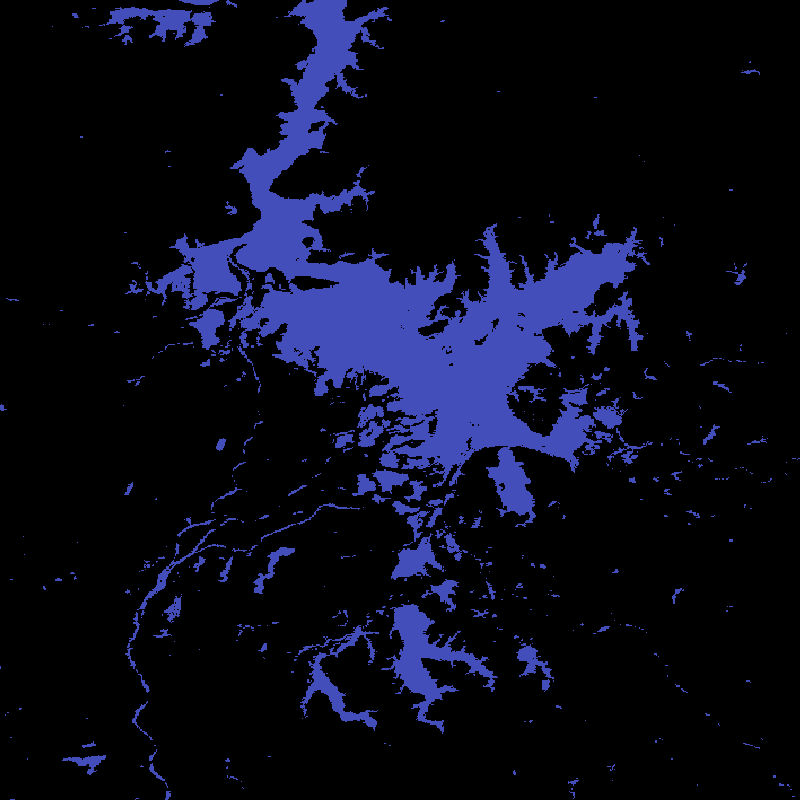
Global WaterPack - MODIS - Daily
The Global WaterPack is a dataset containing information about open surface water cover parameters on a global scale. The water detection is derived from daily, operational MODIS datasets for every year since 2003. The negative effects of polar darkness and cloud coverage are compensated by applying interpolation processing steps. Thereby, a unique global dataset can be provided that is characterized by its high temporal resolution of one day and a spatial resolution of 250 meter. The daily binary layers in this collection contain information whether a pixel was detected as open surface water (1) or not (0). Furthermore, reliability and observation layers provide additional information on the quality of each Global WaterPack pixel.
INSPIRE
Identification
- File identifier
- 641ae58c-17e7-453c-8d40-6c9456f3a758 XML
- Hierarchy level
- Dataset
Online resource
- Protocol
-
WWW:LINK-1.0-http--link
- Protocol
-
WWW:LINK-1.0-http--link
Resource identifier
- Metadata language
- English
- Spatial representation type
- Grid
Encoding
- Format
-
GeoTIFF
Projection
- code
- EPSG:4326
Classification of data and services
- Topic category
-
- Imagery base maps earth cover
- Inland waters
Classification of data and services
Coupled resource
Coupled resource
Classification of data and services
Coupled resource
Coupled resource
Keywords
- GEMET - INSPIRE themes, version 1.0
-
-
Land cover
-
Hydrography
-
Other keywords
- Keywords
-
-
MODIS
-
Terra
-
Aqua
-
Global
-
water bodies
-
water dynamics
-
water extent
-
opendata
-
Geographic coverage
))
Temporal reference
Temporal extent
- Begin
- 2003-01-01T00:00:00
- End
- 2022-12-31T23:59:59
Temporal extent
- Date (Creation)
- 2023-08-02T09:48:00
Quality and validity
- Lineage
-
The main input datasets are daily MODIS products MOD09GQ and MYD09GQ at 250m and MOD10A1 and MYD10A1 at 500m spatial resolution. Additional auxiliary datasets, such as DEM, MOD44W and the ESA-CCI Water Bodies Map v4.0 are included within the pre- and postprocessing. For more information please refer to Klein et al. 2017.
- Denominator
- 500000
Conformity
Conformity
Conformity
Conformity
Conformity
Conformity
- Explanation
-
See the referenced specification.
Restrictions on access and use
- Access constraints
- Es gelten keine Zugriffsbeschränkungen
- Access constraints
-
Nutzungsbedingungen: Lizenz, https://creativecommons.org/licenses/by/4.0 / Terms of use: License, https://creativecommons.org/licenses/by/4.0
- Access constraints
-
{"id": "cc-by-4.0",
"name": "Creative Commons Namensnennung – 4.0 International (CC BY 4.0)",
"url": " http://dcat-ap.de/def/licenses/cc-by/4.0 ",
"quelle": "Copyright DLR (year of production)"}
Responsible organization (s)
Contact for the resource
- Organisation name
-
German Aerospace Center (DLR)
- Organisation name
-
German Aerospace Center (DLR)
- Organisation name
-
German Aerospace Center (DLR)
Responsible organization (s)
Contact for the resource
- Organisation name
-
German Aerospace Center (DLR)
- Organisation name
-
German Aerospace Center (DLR)
- Organisation name
-
German Aerospace Center (DLR)
Metadata information
Contact for the metadata
- Organisation name
-
German Aerospace Center (DLR)
- Date stamp
- 2024-06-27T14:42:34
- Metadata language
- English
- Character set
- UTF8
SDS
Conformance class 1: invocable
Access Point URL
Endpoint URL
Technical specification
Conformance class 2: interoperable
Access constraints
Limitation
Use constraints
Limitation
Responsible custodian
Contact for the resource
Overviews

Spatial extent
Provided by
