 My GeoNetwork catalogue
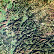
PlanetScope (RESA) - Level 3A OrthoTile
The PlanetScope satellite constellation, called ‘Flock’, consists of multiple launches of groups of individual Dove satellites into a 400 km orbit. Some of them were launched from the ISS. Therefore, on-orbit capacity is constantly improving in capability or quantity. Each Dove satellite is a CubeSat with a size of 10 x 10 x 34 cm. The complete PlanetScope constellation of approximately 130 satellites is able to image the entire land surface of the Earth every day, equating to a daily collection capacity of 200 million km².
In 2014 the first Dove satellites started operationally acquiring images from the earth’s surface. The optical sensors mounted on the individual Dove satellites operate in the visual and near-infrared parts of the electromagnetic spectrum with a spatial resolution between 3 and 5 meters. A third generation of PlanetScope sensors (known as SuperDove or PSB.SD) is currently in orbit and is
producing limited quantities of imagery with 5 spectral bands (BGRNIR + Red Edge). These satellites have the potential to produce imagery with 8 separate spectral bands. The RapidEye Science Archive (RESA), which allows Germany-based researchers to apply for free PlanetScope imagery, is operated by the German Satellite Data Archive (D-SDA) of DLR’s Earth Observation Center and can be accessed via the EOWEB Geoportal. New PlanetScope data as well as archive data which is not yet part of the RESA collections can be applied for at Planet Labs Germany GmbH under the RESA contract. For more information see: https://www.planet.com/resa/
This collection comprises the PlanetScope L3A OrthoTile products which are orthorectified as individual 25 km by 25 km tiles referenced to a fixed, standard image tile grid system. The OrthoTile products are radiometrically-, sensor-, and geometrically-corrected and aligned to a cartographic map projection. The Surface Reflectance layer which corrects for the effects of the Earth's atmosphere is included in the product.
- Identification
- Distribution
- Quality
- Spatial rep.
- Ref. system
- Content
- Portrayal
- Metadata
- Md. constraints
- Md. maintenance
- Schema info
Identification
Data identification
Citation
- Date (Creation)
- 2021-07-30T12:00:00
- Citation identifier
- https://geoservice.dlr.de/catalogue/srv/metadata/6591f901-5fdd-431f-89fc-737c5984baf1
- Presentation form
- Digital image
- Status
- ongoing
- Maintenance and update frequency
- As needed
-
GEMET - INSPIRE themes, version 1.0
-
-
Orthoimagery
-
- Keywords
-
-
urn:eop:DLR:EOWEB:PlanetScope.RESA.L3A_OrthoTile
-
PlanetScope
-
Level 3A
-
OrthoTile
-
Optical
-
visible wavelengths
-
infrared wavelengths
-
- Use limitation
-
Nutzungseinschränkungen: Das DLR ist nicht haftbar für Schäden, die sich aus der Nutzung ergeben. / Use Limitations: DLR not liable for damage resulting from use.
Legal constraints
- Access constraints
- Other restrictions
Legal constraints
- Use constraints
- Other restrictions
- Other constraints
-
Nutzungsbedingungen / License: https://geoservice.dlr.de/resources/licenses/resa/RESA-License-Agreement-Planet-Data-en.pdf
- Spatial representation type
- Grid
- Denominator
- 6250
- Language
- English
- Character set
- UTF8
- Topic category
-
- Imagery base maps earth cover
))
Distribution
Distribution
- Distribution format
-
-
GeoTIFF
()
-
GeoTIFF
()
Digital transfer options
- OnLine resource
-
Planet Labs, Inc.
(
WWW:LINK-1.0-http--link
)
For non-scientific users
- OnLine resource
-
Planet Labs Germany GmbH – RESA
(
WWW:LINK-1.0-http--link
)
For scientific users
- OnLine resource
- EOWEB Collection
Quality
Data quality
- Hierarchy level
- Series
Domain consistency
- Measure identification
- INSPIRE / Conformity_001
Conformance result
Citation
- Date (Publication)
- 2010-12-08
- Explanation
-
See the referenced specification
- Pass
- Yes
- Statement
-
Radiometric and sensor corrections applied to the data. Imagery is orthorectified and projected to a UTM projection.
For more details see:
https://assets.planet.com/docs/Planet_Combined_Imagery_Product_Specs_letter_screen.pdf
Ref. system
- Reference system identifier
- UTM/WGS84
Metadata
Metadata
- File identifier
- 6591f901-5fdd-431f-89fc-737c5984baf1 XML
- Metadata language
- English
- Character set
- UTF8
- Hierarchy level
- Series
- Hierarchy level name
-
Dataseries
- Date stamp
- 2024-06-20T14:12:24
- Metadata standard name
-
ISO 19115-1:2014/19139
Overviews

Spatial extent
Provided by
