 My GeoNetwork catalogue
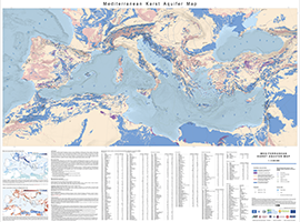
Mediterranean Karst Aquifer Map 1:5,000,000 (MEDKAM)
Karst aquifers constitute important freshwater resources, but are challenging to manage and to protect, because of their unique hydraulic structure and behaviour, representing continuous challenges for research and development. Karst aquifers are widespread and contribute to freshwater supply of most Mediterranean countries and many cities are supplied by karst water, e.g., Rome, Vienna, Montpellier and Beirut. These land surfaces correspond to the main recharge zones of karst aquifers, which are often hydraulically connected over large areas and are highly vulnerable to contamination. The preparation of the Mediterranean Karst Aquifer Map (MEDKAM) generally followed the workflow used for the World Karst Aquifer Map (WOKAM). A new lithological classification has been developed for the MEDKAM, similar to that of the WOKAM, which groups the geological units into four meaningful hydrogeological units: 1). Karst aquifers in sedimentary and metamorphic carbonate rocks. 2). Karst aquifers in evaporite rocks. 3). Various hydrogeological settings in other sedimentary and volcanic formations (karst aquifers are possibly present at depth). 4). Local, poor and shallow aquifers in other metamorphic rocks and igneous rocks (no karst aquifers present at depth).
INSPIRE
Identification
- File identifier
- 65f58412-4a78-4808-9ef6-6b6d9182db8f XML
- Hierarchy level
- Dataset
Online resource
Resource identifier
- code
-
1cf2b0f3-0160-1d79-7c95-1f4d30b5fa1c
- code
- Metadata language
- English
- Spatial representation type
- Vector
Encoding
- Format
-
PDF
- Version
-
n/a
- Format
-
shp
- Version
-
n/a
Projection
- code
- EPSG:25833
Classification of data and services
- Topic category
-
- Geoscientific information
Classification of data and services
Coupled resource
Coupled resource
Classification of data and services
Coupled resource
Coupled resource
Keywords
-
GEMET - INSPIRE themes, version 1.0
-
-
Geologie
-
Geology
-
-
GEMET - Concepts, version 2.4
-
-
Grundwasser
-
Hydrogeologie
-
Groundwater
-
Hydrogeology
-
Other keywords
- Theme
-
-
Karst
-
Aquifer
-
Grundwasservorkommen
-
Groundwater Resources
-
opendata
-
- Place
-
-
Mittelmeer
-
Mediterranean
-
Geographic coverage
))
Temporal reference
Temporal extent
Temporal extent
- Date (Publication)
- 2023-01-27
Quality and validity
- Lineage
-
International Hydrogeological Map of Europe (BGR & UNESCO), Quantitative maps of groundwater resources in Africa (BGS), Bedrock geology of the Arabian Peninsula (USGS)
- Denominator
- 5000000
Conformity
Conformity
Conformity
Conformity
Conformity
Conformity
- Explanation
-
siehe dazu die angegebene Durchführungsbestimmung
Restrictions on access and use
- Access constraints
- Es gelten keine Zugriffsbeschränkungen
- Access constraints
-
Creative Commons Attribution-ShareAlike 4.0 International (CC BY-SA 4.0). Die bereitgestellten Informationen sind wie folgt zu zitieren / The information provided must be quoted as follows: Xanke J, Goldscheider N, Bakalowicz M, Barberá JA, Broda S, Chen Z, Ghanmi M, Günther A, Hartmann A, Jourde H, Liesch T, Mudarra M, Petitta M, Ravbar N, Stevanovic Z (2022) Mediterranean Karst Aquifer Map (MEDKAM), 1:5,000,000. Berlin, Karlsruhe, Paris. https://doi.org/10.25928/MEDKAM .1
- Access constraints
-
{"id": "cc-by-sa/4.0", "name": "Creative Commons Namensnennung - Weitergabe unter gleichen Bedingungen 4.0 International (CC-BY-SA 4.0)", "url": " http://creativecommons.org/licenses/by-sa/4.0/ ", "quelle": "Xanke J, Goldscheider N, Bakalowicz M, Barberá JA, Broda S, Chen Z, Ghanmi M, Günther A, Hartmann A, Jourde H, Liesch T, Mudarra M, Petitta M, Ravbar N, Stevanovic Z (2022) Mediterranean Karst Aquifer Map (MEDKAM), 1:5,000,000. Berlin, Karlsruhe, Paris. https://doi.org/10.25928/MEDKAM.1"}
Responsible organization (s)
Contact for the resource
- Organisation name
-
Bundesanstalt für Geowissenschaften und Rohstoffe (BGR)
- Organisation name
-
BGR, KIT, UNESCO
Responsible organization (s)
Contact for the resource
- Organisation name
-
Bundesanstalt für Geowissenschaften und Rohstoffe (BGR)
- Organisation name
-
BGR, KIT, UNESCO
Metadata information
Contact for the metadata
- Organisation name
-
Bundesanstalt für Geowissenschaften und Rohstoffe (BGR)
- Date stamp
- 2025-03-07
- Metadata language
- English
- Character set
- UTF8
SDS
Conformance class 1: invocable
Access Point URL
Endpoint URL
Technical specification
Conformance class 2: interoperable
Access constraints
Limitation
Use constraints
Limitation
Responsible custodian
Contact for the resource
Overviews
Spatial extent
Provided by
