 My GeoNetwork catalogue
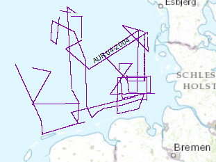
Processed seismic data of Cruise AUR 2004
Continuing the systematic work which was started during a previous BGR expedition with RV AURELIA in Sept./Oct. 2003 the late Tertiary and Quaternary development of the German EEZ was further investigated by seismic profiling. The data format is Society of Exploration Geophysicists SEG Y. Again the research vessel AURELIA was chartered for a period of 21 days from 31st of May to 19th of June 2004. During the cruise the grid of seismic profiles which was aquired in 2003 was completed and data gaps were closed. A total of 2618km of high quality MCS lines were surveyed.
Simple
- Alternate title
-
AUR04 2004
- Date (Creation)
- 2003-06-19
- Citation identifier
- 9758be03-e9e8-4cf4-aa2f-23e1e6cd6299
- Status
- Completed
-
GEMET - INSPIRE themes, version 1.0
-
-
geology
-
Geologie
-
-
GEMET - Concepts, version 2.4
-
-
marine geology
-
Meeresgeologie
-
geophysics
-
Geophysik
-
raw material
-
Rohstoff
-
- Theme
-
-
seismics
-
Seismik
-
two-dimensional seismic reflection
-
zweidimensionale Reflektionsseismik
-
MSSP
-
GeolDG
-
- Place
-
-
North Sea
-
Nordsee
-
German EEZ
-
Deutsche AWZ
-
- Access constraints
- Other restrictions
- Other constraints
- Es gelten keine Zugriffsbeschränkungen
- Use constraints
- Other restrictions
- Other constraints
-
Allgemeine Geschäftsbedingungen, siehe https://www.bgr.bund.de/AGB - General terms and conditions, see https://www.bgr.bund.de/AGB_en . Die bereitgestellten Informationen sind bei Weiterverwendung wie folgt zu zitieren: Datenquelle: AUR04, (c) BGR, Hannover, 2004
- Spatial representation type
- Vector
- Language
- English
- Character set
- UTF8
- Topic category
-
- Geoscientific information
))
- Unique resource identifier
- EPSG:4326
- Distribution format
-
-
Shapefile
(
n/a
)
-
Shapefile
(
n/a
)
- Transfer size
- 3
- OnLine resource
-
AUR04 2004 (Shapefile)
AUR04 2004 im Format ESRI Shape
- OnLine resource
- Profile AUR04-01
- OnLine resource
- Profile AUR04-02
- OnLine resource
- Profile AUR04-03
- OnLine resource
- Profile AUR04-04
- OnLine resource
- Profile AUR04-05
- OnLine resource
- Profile AUR04-5A
- OnLine resource
- Profile AUR04-06
- OnLine resource
- Profile AUR04-07
- OnLine resource
- Profile AUR04-08
- OnLine resource
- Profile AUR04-09
- OnLine resource
- Profile AUR04-10
- OnLine resource
- Profile AUR04-11
- OnLine resource
- Profile AUR04-12
- OnLine resource
- Profile AUR04-13
- OnLine resource
- Profile AUR04-14
- OnLine resource
- Profile AUR04-15
- OnLine resource
- Profile AUR04-16
- OnLine resource
- Profile AUR04-17
- OnLine resource
- Profile AUR04-18
- OnLine resource
- Profile AUR04-19
- OnLine resource
- Profile AUR04-20
- OnLine resource
- Profile AUR04-21
- OnLine resource
- Profile AUR04-22
- OnLine resource
- Profile AUR04-23
- OnLine resource
- Profile AUR04-24
- OnLine resource
- Profile AUR04-25
- OnLine resource
- Profile AUR04-26
- OnLine resource
- Profile AUR04-27
- OnLine resource
- Profile AUR04-27A
- OnLine resource
- Profile AUR04-28
- OnLine resource
- Profile AUR04-29
- OnLine resource
- Profile AUR04-30
- OnLine resource
- Profile AUR04-31
- OnLine resource
- Profile AUR04-32
- OnLine resource
- Profile AUR04-33
- OnLine resource
- Profile AUR04-34
- OnLine resource
- Profile AUR04-35
- OnLine resource
- Profile AUR04-36
- OnLine resource
- Profile AUR04-37
- OnLine resource
- Profile AUR04-37A
- OnLine resource
- Profile AUR04-38
- OnLine resource
- Profile AUR04-39
- OnLine resource
- Profile AUR04-40
- OnLine resource
- Profile AUR04-40A
- OnLine resource
- Profile AUR04-41
- OnLine resource
- Profile AUR04-42
- OnLine resource
- Profile AUR04-43
- OnLine resource
- Profile AUR04-44
- OnLine resource
- Profile AUR04-45
- OnLine resource
- Profile AUR04-46
- OnLine resource
- Profile AUR04-47
- OnLine resource
- Profile AUR04-48
- OnLine resource
- Karte im BGR-Geoviewer
- Hierarchy level
- Dataset
Conformance result
- Date (Publication)
- 2010-12-08
- Explanation
-
siehe dazu die angegebene Durchführungsbestimmung
- Statement
-
During the period from 31st May to 19th of June 2004 BGR acquired seismic lines in the North Sea. The Lines AUR04-01, AUR04-02, AUR04-03, AUR04-04, AUR04-06, AUR04-07, AUR04-08, AUR04-09, AUR04-10, AUR04-11, AUR04-12, AUR04-13, AUR04-14, AUR04-15, AUR04-16, AUR04-17, AUR04-18, AUR04-19, AUR04-20, AUR04-21, AUR04-22, AUR04-23, AUR04-24, AUR04-25, AUR04-26, AUR04-27, AUR04-27A, AUR04-28, AUR04-29, AUR04-30, AUR04-31, AUR04-32, AUR04-33, AUR04-34, AUR04-35, AUR04-36, AUR04-37, AUR04-37A, AUR04-38, AUR04-39, AUR04-40, AUR04-40A, AUR04-41, AUR04-42, AUR04-43, AUR04-44, AUR04-45, AUR04-46, AUR04-47, AUR04-48 are processed (migrated) at BGR, whereas AUR04-05, AUR04-05A are raw data.
- File identifier
- 665c5507-08dc-416f-8296-9991f5cd8814 XML
- Metadata language
- English
- Character set
- UTF8
- Parent identifier
-
Marine Seismic Survey Profiles (MSSP)
06a73c56-06a2-40d8-b806-466222b0760d
- Hierarchy level
- Dataset
- Hierarchy level name
-
Geophysik
- Hierarchy level name
-
GeolDG
- Date stamp
- 2025-04-07
- Metadata standard name
-
INSPIRE Metadata Implementing Rules: Technical Guidelines based on EN ISO 19115 and EN ISO 19119
- Metadata standard version
-
n/a
Overviews
Spatial extent
Provided by
