 www.geodatenkatalog.de (S1F)
Geogenic Groundwater Quality of Germany 1:1,000,000 (GEOGW1000) (WMS)
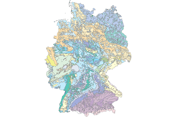
The map shows the representative chemical content of groundwater for 22 hydrogeological subregions of Germany. The classification of each sub-region was based on the TDS value (total dissolved solids) and the chemical inventory. According to the degree of mineralization, five classes of waters were distinguished (very small, low, medium, high and strongly changing solution contents). The classification of the waters by their chemical inventory was made according to the equivalent percentage of the main cations and anions based on the Piper quadruple diagram. With this chemical classification and the degree of mineralization, 22 geogenic groundwater types could be differentiated throughout Germany. The basis for the mapping of geogenic groundwater quality is the "Hydrogeological Regions" map. The water quality data comes from the groundwater monitoring networks of the German federal states, which were collected by the State Geological Surveys or the State Environmental Surveys. Further analyses are based on the data of the former Central Geological Institute (ZGI) of the GDR. In total, sample data of nearly 8,000 observation wells have been evaluated.
|
|
Citation proposal
Bundesanstalt für Geowissenschaften und Rohstoffe (BGR) (2019) . Geogenic Groundwater Quality of Germany 1:1,000,000 (GEOGW1000) (WMS). https://gdk.gdi-de.org/geonetwork/srv/api/records/6b3fabf9-c09b-423f-a20d-f5ea1fde514f |
INSPIRE
Identification
- File identifier
- 6b3fabf9-c09b-423f-a20d-f5ea1fde514f XML
- Hierarchy level
- Service
Online resource
Resource identifier
Encoding
- Format
- png
- Version
- n/a
- Format
- jpeg
- Version
- n/a
- Format
- gif
- Version
- n/a
Projection
Classification of data and services
Classification of data and services
- Service Type
- view
- Coupling Type
- Tight
Coupled resource
Coupled resource
Classification of data and services
- Service Type
- view
- Coupling Type
- Tight
Coupled resource
Coupled resource
Keywords
- GEMET - INSPIRE themes, version 1.0 ( Theme )
-
- Geologie
- GEMET - Concepts, version 2.4 ( Theme )
-
- Grundwasser
Other keywords
- Keywords ( Theme )
-
- Geogene Grundwasserbeschaffenheit
- HAD
- HAD 5.7
- GEOGW
- HK1000
- Keywords ( Place )
-
- Deutschland
Geographic coverage
N
S
E
W
))
Temporal reference
Temporal extent
Temporal extent
- Date ( Publication )
- 2019-08-15
Quality and validity
- Lineage
- Grundlage für die Kartierung der geogenen Grundwasserbeschaffenheit ist die Karte "Hydrogeologische Regionen". Die Wasserbeschaffenheitsdaten stammen aus den Grundwassermessnetzen der deutschen Bundesländer, die von den Landesämtern für Geologie/Bodenforschung bzw. Umwelt erhoben wurden. Weitere Analysen gehen auf den Datenbestand des ehemaligen Zentralen Geologischen Instituts der DDR zurück. Insgesamt wurden Proben aus knapp 8000 Grundwassermessstellen ausgewertet.
Conformity
Conformity
Conformity
Conformity
Conformity
Conformity
Restrictions on access and use
Restrictions on access and use
- Access constraints
- Allgemeine Geschäftsbedingungen, siehe https://www.bgr.bund.de/AGB - General terms and conditions, see https://www.bgr.bund.de/AGB_en. Die bereitgestellten Informationen sind bei Weiterverwendung wie folgt zu zitieren: Datenquelle: GEOGW1000 (c) BGR Hannover 2019
Responsible organization (s)
Contact for the resource
- Organisation name
- Bundesanstalt für Geowissenschaften und Rohstoffe (BGR)
- fis.hy@bgr.de
- Organisation name
- Bundesanstalt für Geowissenschaften und Rohstoffe (BGR)
Responsible organization (s)
Contact for the resource
- Organisation name
- Bundesanstalt für Geowissenschaften und Rohstoffe (BGR)
- fis.hy@bgr.de
- Organisation name
- Bundesanstalt für Geowissenschaften und Rohstoffe (BGR)
Metadata information
Contact for the metadata
- Organisation name
- Bundesanstalt für Geowissenschaften und Rohstoffe (BGR)
- Date stamp
- 2024-01-24
- Metadata language
- German
SDS
Conformance class 1: invocable
Access Point URL
Endpoint URL
Technical specification
Conformance class 2: interoperable
Coordinate reference system
Quality of Service
Access constraints
- Access constraints
- Other restrictions
Limitation
Use constraints
Limitation
- string
- Allgemeine Geschäftsbedingungen, siehe https://www.bgr.bund.de/AGB - General terms and conditions, see https://www.bgr.bund.de/AGB_en. Die bereitgestellten Informationen sind bei Weiterverwendung wie folgt zu zitieren: Datenquelle: GEOGW1000 (c) BGR Hannover 2019
Responsible custodian
Contact for the resource
- Organisation name
- Bundesanstalt für Geowissenschaften und Rohstoffe (BGR)
Conformance class 3: harmonized
Contains Operations
- Operation Name
- GetCapabilities
- Distributed Computing Platforms
- Web services
- Connect Point
- https://services.bgr.de/wms/grundwasser/geogw1000/?
Contains Operations
- Operation Name
- GetMap
- Distributed Computing Platforms
- Web services
- Connect Point
- https://services.bgr.de/wms/grundwasser/geogw1000/?
Overviews
Provided by

Views
6b3fabf9-c09b-423f-a20d-f5ea1fde514f
Access to the portal
Read here the full details and access to the data.
Associated resources
Not available