 www.geodatenkatalog.de (S3L)
Digitale Topographische Karte 1: 25 000 (DTK25)
Das Landeskartenwerk Digitale Topographische Karte 1:25 000 visualisiert die amtlichen Geobasisdaten ATKIS und ALKIS-Gebäude im bundeseinheitlichen Regelblattschnitt.
|
|
Citation proposal
(2024) . Digitale Topographische Karte 1: 25 000 (DTK25). https://gdk.gdi-de.org/geonetwork/srv/api/records/6d772bb5-cfca-344e-84bb-a8b762d99831 |
Simple
Identification info
- Date ( Creation )
- 2007-12-31
- Date ( Publication )
- 2024-04-08
- Date ( Revision )
- 2024-04-03
- Presentation form
- Digital map
Point of contact
Point of contact
- Maintenance and update frequency
- Quarterly
- Keywords ( Theme )
-
- open data
- opendata
- AdVMIS
- Geodaten
- Karten
- Berlin
- Topographisch-Kartographisches Informationssystem
- Amtliches Topografisch-Kartographisches Informationssystem
- ATKIS
- Digitale Topographische Karte 1:25 000
- Digitale Topografische Karte 1:25 000
- DTK
- DTK25
- Digitale Topografische Karte
- Digitale Topographische Karte
- Digitale Topografische Karten
- Digitale Topographische Karten
- Access constraints
- Other restrictions
- Use constraints
- Other restrictions
- Other constraints
- Für die Nutzung der Daten ist die Datenlizenz Deutschland - Namensnennung - Version 2.0 anzuwenden. Die Lizenz ist über https://www.govdata.de/dl-de/by-2-0 abrufbar. Der Quellenvermerk gemäß (2) der Lizenz lautet "Geoportal Berlin / [Titel des Datensatzes]".
- Other constraints
- { "id": "dl-by-de/2.0" , "name": " Datenlizenz Deutschland -Namensnennung - Version 2.0 ", "url": "https://www.govdata.de/dl-de/by-2-0", "quelle": "Geoportal Berlin / [Titel des Datensatzes]" }
- Service Type
- view
- Service Version
- OGC:WMS 1.0.0
- Service Version
- OGC:WMS 1.1.0
- Service Version
- OGC:WMS 1.1.1
- Service Version
- OGC:WMS 1.3.0
N
S
E
W
))
- Extent type code
- true
- Geographic identifier
- 110000000000
- Coupling Type
- Tight
Contains Operations
- Operation Name
- GetCapabilities
- Distributed Computing Platforms
- Web services
- Connect Point
- https://gdi.berlin.de/services/wms/dtk25
- Reference system identifier
- http://www.opengis.net/def/crs/EPSG/0/25833
- Distribution format
-
- Text/HTML (4.01 )
- OnLine resource
-
GetCapabilities Aufruf des WMS mit maschinenlesbarer Antwort
GetCapabilities Aufruf des WMS mit maschinenlesbarer Antwort
- OnLine resource
-
Aufruf des Geoportals Berlin mit Darstellung der Karte und weiterer Metadaten
Aufruf des Geoportals Berlin mit Darstellung der Karte und weiterer Metadaten
- OnLine resource
-
Inhaltliche Beschreibung
Inhaltliche Beschreibung
- Hierarchy level
- Service
- Other
- Dienst
gmd:MD_Metadata
- File identifier
- 6d772bb5-cfca-344e-84bb-a8b762d99831 XML
- Metadata language
- German
- Character set
- UTF8
- Hierarchy level
- Service
- Hierarchy level name
- Digitale Topographische Karte 1: 25 000 (DTK25) Dienst
- Date stamp
- 2024-04-08T14:48:14
- Metadata standard name
- ISO 19115/19119 – BE
- Metadata standard version
- 1.0.0
Overviews
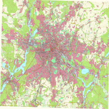
Vorschaugrafik
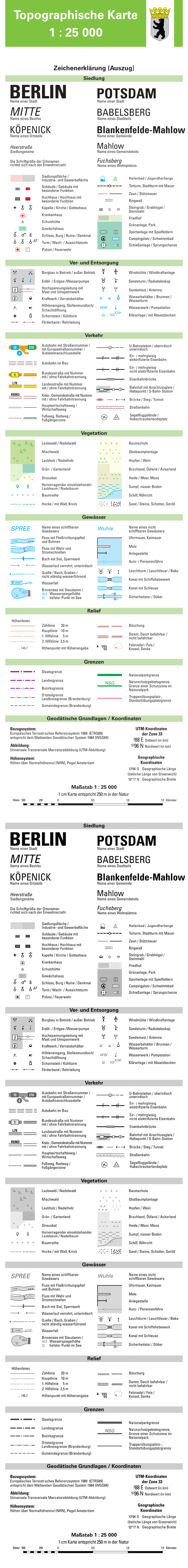
Legende
Provided by

Views
6d772bb5-cfca-344e-84bb-a8b762d99831
Access to the portal
Read here the full details and access to the data.
Associated resources
Not available