 My GeoNetwork catalogue
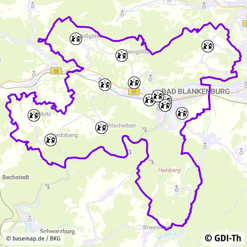
Spielplätze der Stadt Bad Blankenburg
Der Datensatz zeigt die Standorte der frei zugänglichen Spielplätze der Stadt Bad Blankenburg. Es handelt sich um einen Sekundärdatenbestand.
INSPIRE
Identification
- File identifier
- 73005b8c-0db4-4039-8042-19169e129be2 XML
- Hierarchy level
- Dataset
Online resource
- Protocol
-
WWW:DOWNLOAD-1.0-http--download
- Protocol
-
OGC:WFS-http-get-capabilities
- Protocol
-
OGC:WMS-http-get-map
Resource identifier
- Metadata language
- Deutsch
- Spatial representation type
- Vector
Encoding
- Format
-
ESRI Shapefile
- Version
-
1.0
Projection
Classification of data and services
- Topic category
-
- Society
Classification of data and services
Coupled resource
Coupled resource
Classification of data and services
Coupled resource
Coupled resource
Keywords
-
GEMET - INSPIRE themes, version 1.0
-
-
Bodennutzung
-
Other keywords
- Keywords
-
-
Thüringen
-
Spielplatz
-
opendata
-
GOVE
-
REGI
-
SOCI
-
EDUC
-
Geographic coverage
))
Temporal reference
Temporal extent
Temporal extent
- Date (Revision)
- 2026-01-09
Quality and validity
- Lineage
-
Grundlage amtl. Flurkarte, Orthophoto
- Denominator
- 500
Conformity
Conformity
Conformity
Conformity
Conformity
Conformity
- Explanation
-
Originäre Daten
- Explanation
-
mit GDI_DE Testsuite validiert
- Explanation
-
Originäre Daten
- Explanation
-
Originäre Daten
Restrictions on access and use
- Access constraints
-
Nutzungsbedingungen: Datenlizenz Deutschland-Namensnennung 2.0 in JSON Syntax
- Access constraints
-
{"id": "dl-by-de/2.0", "name": "Datenlizenz Deutschland Namensnennung 2.0", "url": " https://www.govdata.de/dl-de/by-2-0 ", "quelle": "© GDI-Th"}
Responsible organization (s)
Contact for the resource
- Organisation name
-
Stadt Bad Blankenburg
Responsible organization (s)
Contact for the resource
- Organisation name
-
Stadt Bad Blankenburg
Metadata information
Contact for the metadata
- Organisation name
-
Thüringer Landesamt für Bodenmanagement und Geoinformation
- Date stamp
- 2026-01-09T10:55:58
- Metadata language
- Deutsch
- Character set
- UTF8
SDS
Conformance class 1: invocable
Access Point URL
Endpoint URL
Technical specification
Conformance class 2: interoperable
Access constraints
Limitation
Use constraints
Limitation
Responsible custodian
Contact for the resource
Overviews
Spatial extent
Provided by
